
Wareham, Dorset facts for kids
Quick facts for kids Wareham |
|
|---|---|
 Wareham Quay |
|
 Coat of Arms of Wareham |
|

Wareham
|
|
| Population | 5,496 (Town parish) 8,270 (both parishes) |
| OS grid reference | SY923873 |
| Civil parish |
|
| Unitary authority |
|
| Ceremonial county | |
| Region | |
| Country | England |
| Sovereign state | United Kingdom |
| Post town | WAREHAM |
| Postcode district | BH20 |
| Dialling code | 01929 |
| Police | Dorset |
| Fire | Dorset |
| Ambulance | South Western |
| EU Parliament | South West England |
| UK Parliament |
|
Wareham is a historic market town in Dorset, England. It is also known as Wareham Town and is a civil parish. The town sits on the River Frome, about 8 miles (13 km) southwest of Poole.
Contents
Wareham's Location and Landscape
Wareham is built in a special spot between the River Frome and the River Piddle. It's located where the Wareham Channel meets Poole Harbour. The River Frome flows through soft rocks like sand, clay, and gravel. This creates wide, flat areas and marsh land. At the end of the river, it forms the big, shallow ria of Poole Harbour. Wareham itself is on a slightly higher, dry piece of land surrounded by these marshy river plains.

The town is on the A351 road, which connects it to Lytchett Minster and Swanage. This road also links to the A35 and A31 roads, and the M27 motorway. Wareham is also where the A352 road to Dorchester and Sherborne begins. These main roads now go around the town center.
Wareham has a train station on the South West Main Line. It used to be a junction for trains going to Swanage. This old line is now the Swanage Railway, a steam railway. The Swanage Railway hopes to extend its service back to Wareham in the future.
Northwest of Wareham, you'll find Wareham Forest, a large forest with many conifer trees. It stretches for miles towards the A35 road. To the southeast are Corfe Castle and the heathland near Poole Harbour. This area includes the Wytch Farm oil field and the Studland & Godlingstone Heath Nature Reserve. About 4 miles (7 km) south is the Purbeck Hills, a chalk ridge. The Isle of Wight is to the east, and the English Channel is 8 miles (12 km) to the south.
Wareham's Long History
Wareham's location has made it an important place for a very long time.
Early Settlements
People lived in the area around Wareham as far back as 9000 BCE. This was during the Mesolithic period. Later, around 3700 BCE, during the Neolithic period, people dug large pits. These pits contained tools made from flint and pieces of pottery. Three axeheads made of greenstone were also found from this time. People continued to work with flint and make pottery during the Bronze Age. The first house found in the area dates back to the mid-15th century BCE.
Saxon Times
There is proof of a small Roman settlement here. However, the town we know today was started by the Saxons. The Roman name for the town is not known. In the year 784, it was called Werham in the Anglo-Saxon Chronicle. This name comes from Old English words meaning 'fish trap' or 'homestead surrounded by water'.
The oldest parts of the town are its walls. These are ancient earth ramparts that go around the town. Alfred the Great likely built them in the 9th century. He wanted to protect the town from the Danes. The Danes invaded Wareham in 876 and only left after Alfred paid them money. They attacked again in 998. In 1015, an invasion led by King Canute left the town in ruins.
Wareham was a special burial place for Saxon kings. King Beorhtric (who died in 802) was buried here. The old minster church of Lady St. Mary has a coffin said to belong to Edward the Martyr. He died in 978 and was quickly buried here. His remains were later moved from Wareham to Shaftesbury Abbey.
By the end of the Saxon period, Wareham was one of the most important towns in Dorset. It even had two places where royal money was made.
Norman Era and Beyond
After the Normans took over England, they built a castle by the River Frome. This castle was the site of many battles in the mid-12th century. These fights were between the forces of King Stephen and Empress Matilda during a civil war. The castle's main tower was destroyed sometime in the 12th or 13th century. Today, no visible parts of the castle remain.
Wareham used to be an important port. But as Poole grew and the river slowly filled with mud, trade in Wareham declined. By the end of the 13th century, most international trade had moved to Poole. Local trade continued at the Quay until the railway was built in the 19th century.
During the English Civil War, Wareham was taken by both the Royalists and the Parliamentarians at different times. In August 1644, 2,000 soldiers loyal to Oliver Cromwell surrounded the town.
After the Monmouth Rebellion in 1685, Wareham was one of the towns where Judge Jeffreys held special trials. These trials were known as the "Bloody Assizes." Some rebels were severely punished on the West Walls, an area now called 'Bloody Bank'.
Great Fire and Modern Times
In 1762, a big fire destroyed two-thirds of Wareham. The town was rebuilt in the Georgian architecture style, using red brick and Purbeck limestone. It kept its old street layout. Some of the Georgian buildings actually hide older structures that survived the fire.
When the First World War began in 1914, Wareham became a military town. Up to 7,000 soldiers lived and trained there. The camp moved to nearby Bovington in 1922. Wareham was mostly unharmed during the Second World War. However, five houses were destroyed when a German bomb fell near St Martin's Church in 1942.
Because of the rivers and marshland around it, Wareham did not grow much in the 20th century. Meanwhile, nearby towns like Poole grew very quickly.
Religious Buildings
Wareham has several places of worship.
- The oldest churches are the Saxon churches of Lady St. Mary and St. Martins-on-the-Walls. Lady St. Mary has been changed a lot, but its beginnings are from before the Norman conquest. St. Martins-on-the-Walls was built around 1030. Both are Anglican churches.
- Holy Trinity Church, built in the 14th century, stands where a Saxon chapel once was. Until 2012, it was a tourist information center.
- Other churches include the Wareham United Reformed Church, St. Edward the Martyr Roman Catholic church, Wareham Methodist Church, and the Evangelical Church.
- Parts of the churchyard at Lady St. Mary are looked after by the Commonwealth War Graves Commission. This is because many soldiers who died in a nearby military hospital during the First World War are buried there. There are also graves of German and Polish soldiers from the Second World War.
Culture and Media in Wareham
Wareham is connected to two other towns: Conches-en-Ouche in France and Hemsbach in Germany. These are called "twin towns."
Since the 16th century, Wareham has been a market town. It still holds a market on Thursdays and Saturdays. In 2005, Wareham was named a Fairtrade Town.
Events and Attractions
- The town has an annual carnival in July. It includes a parade, fireworks, and music by the Quay.
- A newer event is the summer music festival. Bands play on the Quay, at Wareham Town Hall, and in local pubs.
- The Wareham Court Leet, a very old type of local court, meets every night during the last week of November.
Inside St Martin-on-the-Walls church, there is a statue of T. E. Lawrence (also known as Lawrence of Arabia). He is shown wearing Arab clothes. Lawrence is buried at Moreton Churchyard. Near Wareham are Clouds Hill, where Lawrence lived, and Bovington army camp. Lawrence died after a motorbike accident near here.
The Wareham Town Museum, on East Street, has a special section about T. E. Lawrence. The museum also has many items that show the history of the town.

Local Organizations and Media
The Royal Air Force Air Cadets has a squadron in Wareham called 2185 (Wareham) Squadron ATC. The cadets often help with charity events in the town, like the carnival. They also do training and parades. This squadron has a smaller group based in Swanage.
Local news and TV shows come from BBC South and ITV Meridian. TV signals are received from the Rowridge TV transmitter.
Local radio stations include BBC Radio Solent, Heart South, Greatest Hits Radio South, and Nation Radio South Coast. The Wareham Advertiser is the town's local weekly newspaper.
Sports in Wareham
Wareham is home to Wareham Rangers Football Club. They play in the Dorset Premier League. It is also the home of Swanage and Wareham RFU, a rugby club. There is a sports center and swimming pool about 500 meters west of the town center.
People from Wareham
Many interesting people have connections to Wareham:
- John Hutchins was a church leader in Wareham from 1743 to 1773. He wrote a book called The History & Antiquities of the County of Dorset. He lived in Wareham until he died and is buried at Lady St. Mary church.
- Edwin Keppel Bennett, a writer, poet, and German expert, was born in Wareham in 1887.
- Shelley Preston, a British singer and member of the pop group Bucks Fizz, grew up in Wareham.
- T. E. Lawrence lived nearby at Clouds Hill and often visited Wareham in his later years.
- David Mellor, a British politician, was born in Wareham in 1949.
- Actor Edward Fox lives nearby. In 2010, he spoke out against building a supermarket outside the town.
- Chad Gould lived here during his childhood.
- Former footballer David Best (footballer) was born in Wareham.
- Dougal Dixon, a geologist, paleontologist, and author, has lived in Wareham since 1978.
Wareham's Population Details
The population of Wareham according to the 2001 UK Census was 5,665 people living in 2,545 homes. Most of Wareham's population (99%) are White. About 80% of people said they were Christian, while 12% said they had "No religion."
Wareham has a higher number of older people compared to the national average. About 29% of the population is over 60 years old. The biggest job area for people in Wareham is manufacturing (16.3%). Other important job areas include:
- Buying and selling goods, and fixing cars (13.5%)
- Real estate and business activities (12.2%)
- Health and social work (10.5%)
Images for kids
-
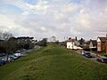
"Bloody Bank" is the high point in the distance, on West Walls
-

Lady St. Mary Church
-
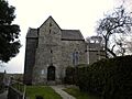
St. Martin's church


See also
 In Spanish: Wareham (Dorset) para niños
