
Wareham Castle and town defences facts for kids
Quick facts for kids Wareham Castle and town defences |
|
|---|---|
| Dorset, England | |

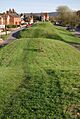
Western part of the walls
|
|

Wareham Castle and town defences
|
|
| Coordinates | 50°41′03″N 2°06′44″W / 50.68422°N 2.11218°W |
| Site information | |
| Owner | Private and town council |
| Condition | Earthworks remain |
| Site history | |
| Materials | Stone, timber and earth |
| Battles/wars | English Civil War |
Wareham Castle and the town's defences, often called the Walls by local people, were strong protective structures in the town of Wareham in Dorset, England. These defences helped protect the town and its people for many centuries.
Contents
Early History of Wareham's Defences (1st-11th Century)
The area where Wareham is located today was likely settled even before the Romans arrived. The Romans built a settlement here because it was a great strategic spot along the River Frome. Later, in the late 500s, the Saxons took control of the area.
Wareham as an Anglo-Saxon Burh
By the end of the 800s, Wareham had become one of the most important Anglo-Saxon burhs in Dorset. A burh was a fortified town or settlement built by King Alfred and his son Edward to defend the kingdom of Wessex. It's possible that Wareham already had some defences that the Saxons improved upon.
The defences at Wareham covered a large rectangular area, about 90 acres in size. They were made up of an earth bank with a protective ditch. On top of the bank were ramparts (defensive walls) made of timber. These ramparts were very long: about 585 yards on the west side, 670 yards on the north, and 760 yards on the east. We don't know the exact length of the southern side, which ran along the river.
There were four entrances into the town, one on each side. Around the late 900s or early 1000s, the timber parts of the defences were replaced with stone. To pay for these important defences, a system of taxes was set up. Records from King Edward's time show that 1,600 "hides" (a unit of land) were set aside for Wareham. This was enough to maintain 2,200 yards of ramparts.
Wareham Castle and Town Walls (12th-16th Centuries)
Wareham Castle was built in the southwest corner of the old Anglo-Saxon earthworks. It was a "motte and bailey" castle. This means it had a large mound (the motte) with a tower on top, and two enclosed areas (the inner and outer baileys) protected by timber defences and a ditch.
Building the Castle
We don't know exactly when the castle was built. It might have been constructed soon after the Norman Conquest in 1066, but there's no physical proof of this today. If it was built then, many houses in that part of town might have been torn down to make space for it. The castle was likely placed in the southwest because there might have been an old Anglo-Saxon royal house there before.
In 1137, Robert, Earl of Gloucester, took control of the castle and worked on it. A small, square stone tower, about 37 feet across, was built on top of the motte. This tower, called a keep, was probably built in the early 1100s. The bailey areas were protected by a strong stone wall, which was known to be 5 feet thick in some places.
The Anarchy and Decline
During a civil war in the 1140s, known as The Anarchy, Wareham Castle was on the border between the lands of two rivals fighting for the throne: King Stephen and Empress Matilda. Robert, Earl of Gloucester, supported Matilda. Because of this, the castle changed hands between him and Stephen several times. The town itself might even have been burned by Stephen's forces. After the fighting ended, nearby Corfe Castle became the most important military fort in the region.
After 1154, the Earls of Gloucester controlled Wareham Castle. The town's economy wasn't doing well in the late 1100s and 1200s. However, in 1207, King John took the castle and had it repaired. He used it as a stopping point on his way to Corfe Castle. After King John, the castle passed to the Earls of Clare, who didn't pay much attention to it. The outer bailey ditch was filled in during the early 1200s.
The river also started to fill with silt, which meant the port became less important. Trade moved to Poole instead. By the 1300s, Wareham was facing economic decline.
Wareham's Defences in Later Centuries (17th-21st Centuries)

During the English Civil War in the 1640s, Wareham first supported Parliament. In 1642, £60 was spent to improve the town walls. Royalist forces, led by Sir Ralph Hopton, took the town in 1643. But Parliament's soldiers, led by Sir Ashley Cooper, recaptured it in 1644 by forcing their way through the West Gate in the walls.
The town wall was made stronger during the war, possibly with round platforms at key points. Parliament was told that the defences were still useful and too strong to be "slighted" (deliberately damaged so they couldn't be used). In 1685, seven men were executed on the west bank of the defences for their part in the Monmouth Rebellion. This part of the wall is now known as the "Bloody Bank."
The Castle Today
We don't know when the castle was finally left empty. By the 1700s, buildings were starting to appear on the eastern edge of the castle site. The rest of the area was open land called Castle Green. In the early 1800s, houses were built around the base of the motte. Later, in the late 1800s, the motte was enclosed. A large house called Castle Close was built on top of the motte in 1911.
Building this house changed the shape of the motte a lot. It is now 250 feet across at the base and 120 feet across at the top. Most of the castle ditch was filled in, but some parts that remain are 70 feet wide and 22 feet deep. The foundations of the old keep (the stone tower) are still inside the motte. The paths of the inner and outer baileys are now followed by Pound and Trinity lanes.
The Town Walls Today
It's not known when the stone from the Anglo-Saxon defences was removed. Around 1850, a road was cut through part of the western town wall. More changes were made in 1940 during the Second World War to protect the wall from possible enemy tank attacks. In 1956, the town authorities took over managing and protecting the remaining walls.
The Anglo-Saxon earthwork defences are still up to 55 feet across and 17 feet high in some places. However, the southern line along the river has been lost, and only small parts of the eastern side remain. The southeast corner was destroyed before the 1700s.
Early studies of the Anglo-Saxon defences happened in 1910, 1930, and 1951. More detailed excavations (digs) were carried out between 1952 and 1954. Today, the remains of Wareham Castle and the town defences are protected under UK law as a scheduled monument, which means they are important historical sites.
Images for kids
-
Western part of the walls
-
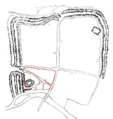
Depiction of the surviving castle and walls in 1888; red-dotted line shows the line of the castle's inner and outer baileys
