
Blandford Forum facts for kids
Quick facts for kids Blandford Forum |
|
|---|---|
.JPG) Market Place, in the town centre |
|

Blandford Forum
|
|
| Population | 10,355 (2021 Census) |
| OS grid reference | ST886069 |
| • London | 101 mi (163 km) NE |
| Civil parish |
|
| Unitary authority |
|
| Ceremonial county | |
| Region | |
| Country | England |
| Sovereign state | United Kingdom |
| Post town | BLANDFORD FORUM |
| Postcode district | DT11 |
| Dialling code | 01258 |
| Police | Dorset |
| Fire | Dorset |
| Ambulance | South Western |
| EU Parliament | South West England |
| UK Parliament |
|

Blandford Forum is a lively market town in Dorset, England. It sits right by the River Stour, about 13 miles (21 km) north-west of Poole. In 2021, about 10,355 people lived here.
The town is famous for its beautiful Georgian architecture. This style of building came about after a huge fire in 1731. The town was rebuilt with help from an Act of Parliament and a gift from King George II. Local architects, the John and William Bastard, designed many of the new buildings.
Blandford's economy relies on different things. These include services like shops and healthcare, and also light industries. Just 2 miles (3 km) north-east of town is Blandford Camp, a military base. It's home to the Royal Corps of Signals, which handles communications for the British Army. You can also find the Royal Signals Museum there.
Contents
- A Look at Blandford's Past
- How Blandford is Governed
- Blandford's Location and Surroundings
- Amazing Georgian Buildings
- Blandford's Population and Jobs
- Getting Around Blandford
- Learning in Blandford
- Fun Things to Do and See
- Sports and Leisure
- Community Places
- Nature in Blandford
- Famous People from Blandford
- Blandford's Twin Towns
- Images for kids
- See also
A Look at Blandford's Past
Blandford has been an important crossing point over the River Stour since Anglo-Saxon times. The name Blandford comes from an old English word. It probably means a shallow river crossing where small fish like gudgeon were found.
By the 1200s, the settlement on the north side of the river grew into a busy market town. It had a livestock market that served the many dairy farms in the nearby Blackmore Vale. In the early 1300s, it was even called Cheping Blandford, with "Cheping" meaning "market". The Latin word Forum was added later, around 1540.
In the 1630s, Blandford was described as a "fair Market Town" that was "well inhabited and of good Traffic." During the 1600s English Civil War, most people in Blandford supported the King.
In the 1700s, Blandford was a centre for making lace. Some people even said that the lace made here was "the finest bonelace in England." The town was also important for making malt and brewing beer.
The Great Fire of 1731

On June 4, 1731, a terrible event known as "the great fire" destroyed almost all of Blandford's buildings. This was not the first fire, but it was the worst. It started in a workshop that made candles. Within a few hours, nearly 90% of the town was gone. Even buildings across the river were burned.
Some important buildings did survive, like the Ryves Almshouses and Dale House. An Act of Parliament was passed to help rebuild the town. It said that new buildings had to be made of brick and tile. King George II even donated £1,000 to help.
| Blandford Forum (Rebuilding After the Fire) Act 1731 | |
|---|---|
| Act of Parliament | |

|
|
| Citation | 5 Geo 2 c 16 |
Over the next ten years, the town was rebuilt. Local architects John and William Bastard designed the new town. They made the streets wider and improved the market place. New buildings included a town hall, a school, and a church. The centre of Blandford still looks much like it did after this rebuilding.
Blandford After the Fire

After the fire, Blandford continued to be a busy market town. Making wool and buttons also became important. The brewing and hotel businesses grew too. In 1756, a new turnpike road was built through the town, connecting Salisbury and Dorchester. This brought more visitors and helped the town's economy.
Later, in the 1800s, more houses were built. Rail transport arrived in Blandford in the 1860s. However, this did not change the town's economy very much.
In the 1900s, Blandford's weekly animal market slowly disappeared. This was partly because cars and trucks made it easier to go to bigger markets in other towns. The Blandford Fair, a seasonal sheep fair, also stopped happening.
How Blandford is Governed
Blandford is part of the North Dorset parliamentary area in the United Kingdom. This area elects one MP to the national parliament. Currently, the MP is Simon Hoare from the Conservative party.
Locally, Blandford is managed by Dorset Council. This council provides most services for the area. The Blandford Forum Town Council also helps run the town. They are in charge of things like parks, play areas, and the town cemetery. They also manage the indoor market and help with grass cutting.

For local elections, Blandford is divided into four areas called wards. These are Blandford Central, Blandford Hilltop, Blandford Langton St.Leonards, and Blandford Old Town. These wards elect 13 councillors to the Blandford Forum Town Council. The mayor of Blandford for 2022-2023 was Colin Stevens.
Blandford's Location and Surroundings

Blandford is located between two beautiful areas: Cranborne Chase and the Dorset Downs. It's also south-east of the Blackmore Vale. The town is built in the valley of the River Stour. Most of it is on higher ground north-east of the river. However, some parts are south of the river in Blandford St Mary.
The ground beneath Blandford is mostly Cretaceous chalk. In some places, there are also deposits of alluvium (river mud) in the flood plain, and clay with flints on the highest parts of the town.
The area around Blandford is very special. It's almost completely surrounded by land that is protected for its natural beauty. This includes the Dorset National Landscape (an Area of Outstanding Natural Beauty, or AONB) to the west. The Cranborne Chase and West Wiltshire Downs AONB is to the north and east.
Amazing Georgian Buildings
Most of the buildings in Blandford's town centre are Georgian. This is because the town was rebuilt after the 1731 fire. Not much has changed since then. One expert, Nikolaus Pevsner, said that "hardly any other town in England can be compared with it."
A report in 1970 called Blandford "the most complete and cohesive surviving example of a Georgian country town in England." The Market Place area was even called "a brilliant master piece." Many buildings here are listed as Grade I by English Heritage. This means they are very important historical buildings. These include the church, the town hall, and several buildings in Market Place.
St Peter and St Paul Church

The parish church of St Peter and St Paul was built between 1732 and 1739. It's a classical building with a cupola (a small dome) on top of its tower. The original plan was for a tall steeple, but there wasn't enough money. The architect, John Bastard, was not happy about the wooden cupola instead!
Inside, the church still looks much like it did in Georgian times. It has its original font, pulpit, and box pews. The organ, built in 1794, is very special. It's one of the most complete organs by George Pike England that still exists. Some say it was meant for a chapel in London but was too big, so King George III gave it to Blandford.
Blandford Forum Town Hall
The Blandford Forum Town Hall is in the Market Place. It was built in 1734. The front of the building is made of Portland stone. The ground floor has three arches that lead to an open area called The Shambles. This area used to be part of the market. At the back is the old corn exchange, a large hall built in the late 1800s.
Other Notable Buildings
Coupar House, built around 1750, is the largest private house in Blandford from after the fire. It has a beautifully decorated inside and a special staircase.

The Old House was probably built between 1650 and 1670. It has an unusual design with a steep roof and wide eaves.
The Pump House fire monument was built by John Bastard in 1760. It's made of Portland stone and stands near the church. It was built to remember the great fire and to help prevent future fires by providing water. The words on its wall say it's there "... to prevent by a timely Supply of Water, (with God's Blessing) the fatal Consequences of FIRE hereafter."

South of the town, a six-arch stone bridge crosses the River Stour. It was repaired in 1726. The water meadows between the bridge and the town are crossed by a raised path and two smaller bridges.
Blandford's Population and Jobs
In 2021, the population of Blandford Forum was 10,355 people. The town's population has grown quite a bit since 1981.
Jobs in Blandford
Many people in Blandford work in public services, education, and health. Shops, restaurants, and hotels also provide many jobs. There are also jobs in manufacturing and construction.
Blandford has five industrial estates and business parks. These are mostly located near the bypass road on the north-east side of town. In 2009, there were 370 businesses providing jobs in Blandford.
Big government employers include the Environment Agency and Dorset Council. The Royal Corps of Signals at Blandford Camp is also a major employer. They have a modern training college there.
Large shops like Co-op (now Marks & Spencer) and Tesco employ many people. Other national shops include Iceland, Boots, and WHSmith. Blandford also has an outdoor market every Thursday and Saturday. An indoor market is held twice a week in the Corn Exchange.
Schools like Bryanston School, Clayesmore senior school, and The Forum School are important employers in the area. Other companies like Damory Coaches and the brewing company Hall and Woodhouse also provide many jobs.
Getting Around Blandford

Blandford is located where two main roads, the A350 and A354, meet. However, a bypass road goes around the east side of the town. The B3082 road connects Blandford Forum to Wimborne Minster.
Buses run from Blandford to places like Poole, Bournemouth, Salisbury, and Shaftesbury. The main bus company is Wilts & Dorset.
Blandford is about 15 miles (24 km) from Bournemouth Airport and 15 miles (24 km) from Poole railway station. From 1860 to 1966, Blandford Forum railway station was a stop on the Somerset and Dorset Joint Railway. This railway line went from Bath to Bournemouth. The station and the entire line closed to passengers in 1966. The station was even mentioned in the 1963 song "Slow Train" by Flanders and Swann.
Learning in Blandford
Blandford Forum has two primary schools: Archbishop Wake and Milldown. Archbishop Wake school moved to a new building in 2008. Other primary schools in nearby villages also send their students to Blandford.
Students usually move to The Blandford School at age 11. This is a secondary school in the west of Blandford. It also has a sixth form for older students.
Several private schools are located near Blandford. These include Bryanston School, Canford School, Clayesmore School, and Milton Abbey School.
Fun Things to Do and See
Festivals and Events
The Blandford Georgian Fayre is a special one-day event held every year in early May. It celebrates the town's Georgian history. You can see cultural shows, visit stalls, watch historical re-enactments, enjoy music and dancing, and find a fun fair by the River Stour.
The town also has an annual carnival. The famous Great Dorset Steam Fair is held nearby in Tarrant Hinton.
Museums to Explore

Blandford and its surrounding area have three interesting museums:
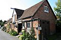
- Blandford Town Museum: Located in Bere's Yard, this museum shows items from the town's history. It also has a small Victorian garden. It's free to enter but closed on Sundays and in winter.
- Blandford Fashion Museum: In The Plocks, this museum has collections of clothes from the early 1700s to the 1970s. It's also closed in winter.
- Royal Signals Museum: This museum is at the Blandford Camp military base. It has items about the history of the Royal Corps of Signals and military communication since the Napoleonic Wars.
Blandford in Books and Songs
The Stoure river, which flows through Blandford, was mentioned by Edmund Spenser in his 1590 poem The Faerie Queene.
Blandford also appears in Thomas Hardy's novels. He called it the Wessex town of Shottesford Forum.
As mentioned before, the old Blandford Forum railway station was featured in the 1963 song Slow Train by Flanders and Swann.
Local Media
Blandford has local radio stations like BBC Radio Solent (103.8 FM) and Greatest Hits Radio South (96.6 FM). BFBS Radio also broadcasts from the military base on 89.3 FM. Local news and TV shows come from BBC South and ITV Meridian.
Sports and Leisure

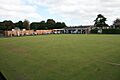
Blandford Forum has a Non-League football club called Blandford United F.C.. They play at Blandford Recreation Ground.
The Blandford Bowls Club has a green with six rinks on the recreation ground. They play in several men's and women's leagues.
Blandford Cricket Club has three men's teams and several youth teams. They play at their own cricket ground.
Blandford Rugby Football Club is based at Larksmead Recreational Ground.
Community Places
Blandford Community Hospital on Milldown Road offers minor surgery, therapy, and rehabilitation services.
Blandford Library, on The Tabernacle, has books, music, and movies to borrow. You can also use the internet there.

Public open spaces in Blandford include Park Road Recreation Ground, which has football and cricket pitches. Larksmead Playing Field has rugby pitches and is home to the Blandford Rugby Club. There are also pitches at The Blandford School.
In the town centre, next to the main post office, is Woodhouse Gardens. This is a small public garden with a pavilion that can be rented for events.
Nature in Blandford
.jpg)
The Blandford fly (Simulium posticatum) is a small biting fly that lives in the area. It's only about 2–3 mm long. In recent years, special sprays have been used in the river to reduce their numbers.
The Blandford Elm is a very rare type of wych elm tree. It has very large leaves. This tree was first grown by a nursery in Blandford Forum in the 1840s. Today, only one known specimen survives, in Edinburgh.
Famous People from Blandford
Blandford is the birthplace of several important people:
- Three bishops from the 1700s: William Wake (Archbishop of Canterbury), Thomas Lindesay (Archbishop of Armagh), and Samuel Lisle (Bishop of Norwich).
- Members of the important Pitt family, including William Pitt and Thomas Pitt.
- Frederick Abberline (1843–1929), a chief inspector for the London police who investigated the Jack the Ripper case.
- The composer and organist Albert Mallinson (1878–1946) lived in Blandford.
- The sculptor Alfred Stevens (1817–1875), who created the Duke of Wellington's monument in St Paul's Cathedral.
- Reginald Heber Roe (1850–1926), the first vice-chancellor of the University of Queensland.
- The surgeon Sir Alfred Downing Fripp.
- Sir Roy Welensky (1907–1991), who was Prime Minister of the Federation of Rhodesia and Nyasaland, lived in Blandford from 1981 until he passed away.
Blandford's Twin Towns
Blandford Forum is twinned with two towns in other countries:
- Mortain, France
- Preetz, Germany
Images for kids
-
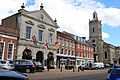
Market Place, in the town centre
-
Blandford originated at a fording point over the River Stour
-
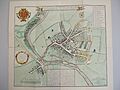
Plan showing the extent of damage of the 1731 fire; the properties shaded black were destroyed, those shaded yellow survived.
-
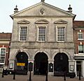
Blandford Forum Town Hall, rebuilt in 1734
-
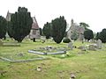
Blandford Cemetery, one of the responsibilities of the Town Council
-
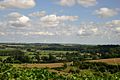
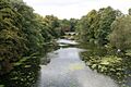
The Stour Valley immediately north of the town; much of the countryside around Blandford is designated as an Area of Outstanding Natural Beauty
-
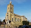
Church of St. Peter and St. Paul
-
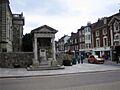
Pump House fire monument
-
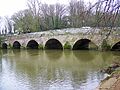
Bridge over the River Stour
-
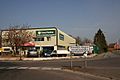
Blandford Heights industrial estate on the northern edge of the town
-
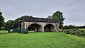
Former Somerset and Dorset railway bridge at Blandford Forum. Following closure of the line, the span over the river (right) was demolished, and the earth embankment on the left was reused for nearby flood defence work, leaving it as a bridge to nowhere.
-
Blandford Town Museum
-
Blandford Bowls Club
-
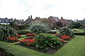
Woodhouse Gardens
-
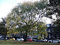
Blandford Elm, Edinburgh (2016)

See also
 In Spanish: Blandford Forum para niños
