Watts Hill facts for kids
Quick facts for kids Watts Hill |
|
|---|---|

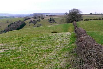
View across Watts Hill, close to the C12, with Whitcombe Bottom just beyond.
|
|
| Highest point | |
| Elevation | 262 m (860 ft) |
| Prominence | 69 m (226 ft) |
| Parent peak | Lewesdon Hill |
| Geography | |
| Location | Dorset, England |
| Parent range | Dorset Downs |
| OS grid | ST673036 |
| Topo map | OS Landranger 194 Explorer No. 117 |
Watts Hill is a special hill located in Dorset, a county in England. It's part of a group of hills called the Dorset Downs. Watts Hill is one of the highest points in Dorset, reaching about 261 or 262 meters (that's about 856 feet) above sea level.
Where is Watts Hill?
Watts Hill is found about 1½ miles north of a village called Cerne Abbas. It sits above another small village named Minterne Parva. The hill is also about 12 kilometers (or 7½ miles) north of Dorchester, which is the main town of Dorset.
Watts Hill is the highest point on a long ridge that runs from north to south. On the southern part of this ridge, you can find the famous Cerne Abbas Giant. This is a very old and large outline of a man carved into the hillside, but no one is quite sure how old it is or who made it!
About a mile to the northwest of Watts Hill is Dogbury Hill. If you cross the A352 road, you'll find Telegraph Hill and High Stoy. High Stoy is a well-known spot that has been used for filming movies and TV shows.
A Look Back in Time: Watts Hill's History
The area around Watts Hill has a lot of clues that show people lived there a very long time ago, even before written history. Near the Cerne Abbas Giant, you can see what's left of an ancient settlement. There's also a tumulus, which is a mound of earth built over a grave, and an earthwork. An earthwork is a large bank or ditch made by people, often for defense or to mark boundaries.
You can find similar old features further north near Dogbury Hill. These ancient remains tell us that people have been living and using this land for thousands of years.
 | Georgia Louise Harris Brown |
 | Julian Abele |
 | Norma Merrick Sklarek |
 | William Sidney Pittman |

