
Lewesdon Hill facts for kids
Quick facts for kids Lewesdon Hill |
|
|---|---|

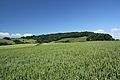
Lewesdon Hill from the west
|
|
| Highest point | |
| Elevation | 279 m (915 ft) |
| Prominence | 185 m (607 ft) |
| Parent peak | Staple Hill |
| Listing | Marilyn, Hardy, County Top |
| Geography | |

Lewesdon Hill
Location in Dorset
|
|
| Location | Dorset, England |
| OS grid | ST437011 |
| Topo map | OS Landranger 193 Explorer 116 |
| Climbing | |
| Easiest route | From Beaminster on the Wessex Ridgeway |
Lewesdon Hill is a tall hill in west Dorset, England. Standing at 279 metres (915 ft) high, it's the highest point in all of Dorset! Imagine standing on top of the tallest spot in the whole county.
Contents
Where is Lewesdon Hill?
Lewesdon Hill is located in the western part of Dorset, England. It's about 4 kilometers (2.5 miles) west of a town called Beaminster. You can also find it near villages like Broadwindsor and Stoke Abbott.
To the south of the hill, you'll see the beautiful Marshwood Vale. To the north, there's the valley of the River Axe.
The Highest Point in Dorset
Lewesdon Hill is known as the "county top" of Dorset. This means it's the highest natural point in the entire county. The very top of the hill is a long, narrow ridge. It's surrounded by lovely beech woods. The actual highest spot is a small grassy mound at the eastern end of this ridge.
For a long time, people thought another nearby hill, Pilsdon Pen, was the tallest. Pilsdon Pen is 277 meters (909 feet) high. But modern surveys showed that Lewesdon Hill is actually 2 meters (6.5 feet) taller! Dorset's third highest point is Bulbarrow Hill, which is 274 meters (899 feet) high.
Because Lewesdon Hill rises so much higher than the land around it (185 meters or 607 feet), it's called a "Marilyn." This is a special term for hills in the British Isles that have a certain height difference from their surroundings.
How the Hill Was Formed
Lewesdon Hill is made of a type of rock called upper greensand. This rock is much stronger and harder than the clay soil around it. Over many, many years, rain and wind slowly wore away the softer clay. But the tougher greensand resisted this wearing-down process, which is called erosion. That's why Lewesdon Hill stands tall today!
History of Lewesdon Hill
Like many other high hills in Dorset, Lewesdon Hill has an interesting past. It was once the site of an Iron Age hill fort. The Iron Age was a time in history from about 800 BC to 100 AD. People built these forts on high ground for protection.
You can still see parts of the original banks (walls) and ditches that made up the fort. However, some parts have been changed over time by people digging for gravel or cutting down trees.
Lewesdon Hill also played a part in English history in 1588. It was one of the places where a special beacon (a large fire) was lit. These beacons were used to warn people that the Spanish Armada was coming to attack England.
Visiting Lewesdon Hill
Lewesdon Hill is now owned by the National Trust, a charity that protects important places in England. This means it's open for everyone to enjoy!
There are two main walking paths that lead up to the top of the hill. One path starts from the village of Broadwindsor. The other path starts from Coombe Lane, which is off the B3162 road between Broadwindsor and Bridport. The Coombe Lane path takes you over another smaller hill called Crabb's Hill, which is privately owned.
A walking trail called the Wessex Ridgeway also passes along the east-west footpath on Lewesdon Hill. It's a great place for a hike and to enjoy the views!
Images for kids
-
Lewesdon Hill from the south
-
View of Lewesdon Hill from Leweston Farm in 1963


