
Pilsdon Pen facts for kids
Quick facts for kids Pilsdon Pen |
|
|---|---|

Pilsdon Pen from the southeast
|
|
| Highest point | |
| Elevation | 277 m (909 ft) |
| Prominence | 83 m |
| Listing | Tump |
| Geography | |
| Location | Dorset, England |
| Parent range | Marshwood & Powerstock Vales |
| OS grid | ST413011 |
| Topo map | OS Landranger 193 |
| Climbing | |
| Easiest route | From the car park at Lob Gate |


Pilsdon Pen is a big hill in Dorset, located in South West England. It stands 277 metres (about 909 feet) tall. You can find it at the northern end of the Marshwood Vale, about 4.5 kilometres (2.8 miles) west of Beaminster. This hill is the second highest point in Dorset and offers amazing views that stretch for many miles. The Pinney family gave Pilsdon Pen to the National Trust in 1982, so it's now protected for everyone to enjoy. For a long time, people thought it was the highest hill in Dorset. However, modern surveys showed that nearby Lewesdon Hill is actually 2 metres taller.
Contents
What is Pilsdon Pen Made Of?
Pilsdon Pen is a special type of rock formation called a lower greensand outcrop. This rock formed during the Cretaceous period, which was a very long time ago. It sits among older rock layers from the Jurassic period, which are made of marl (a type of soil) and clay. The hill is also located where the chalk rocks of South-East England meet the granite rocks found in Devon and Cornwall.
Ancient History of Pilsdon Pen
The very top of Pilsdon Pen has an ancient Iron Age hill fort. This fort was built by the Durotriges, an ancient British tribe. It had many defensive walls, which is why it's called "multivallate."
- Digging Up the Past: In the 1960s, archaeologists Peter Gelling and his wife Margaret Gelling from the University of Birmingham dug up parts of the hill fort. They were asked to do this by Michael Pinney, whose family owned the land.
- Homes of the Past: During their digs, they found the remains of 14 roundhouses. These were circular homes where people lived inside the hill fort.
- More Surveys: Other groups have also studied the hill fort. The National Trust did surveys in 1982, and the Royal Commission on the Historical Monuments of England did more in 1995. The University of Bournemouth also carried out surveys in 2016.
There are also some square-shaped structures in the middle of the fort. Experts have different ideas about how old these are. Some think they might be "pillow mounds" from the Middle Ages. These were man-made mounds used to breed rabbits for food. Others think they could be even older. It's hard to tell for sure because the soil is acidic, which means bones and pottery don't last well.
Pilsdon Pen in the Landscape
Pilsdon Pen is surrounded by other interesting high points.
- Lewesdon Hill: This is Dorset's highest point, standing at 279 metres. It's about 4 kilometres (2.5 miles) east of Pilsdon Pen.
- Blackdown Hill: This hill is about 2 kilometres (1.2 miles) northwest and is 215 metres tall.
Pilsdon Pen was also an important spot for mapping Britain a long time ago. Between April and June 1845, it was used as a main point for the Principal Triangulation of Great Britain. This was a huge project to accurately map the entire country.
Wordsworths and Pilsdon Pen
From 1795 to 1797, the famous poets Dorothy and William Wordsworth lived nearby. They stayed at Racedown House, which was also owned by the Pinney family, just west of Pilsdon Pen. They loved to walk in the area for about two hours every day. The hills around them, including Pilsdon Pen, made Dorothy feel better. She missed the mountains of her home in Lakeland, but these hills reminded her of them.
She wrote about how the hills, even though not as big as mountains, still felt wild and beautiful:
"We have hills which, seen from a distance almost take the character of mountains, some cultivated nearly to their summits, others in their wild state covered with furze and broom. These delight me the most as they remind me of our native wilds."

Images for kids
-
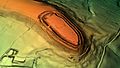
A 3D view of the digital terrain model of Pilsdon Pen.

