Marshwood Vale facts for kids
Quick facts for kids Marshwood Vale |
|
|---|---|
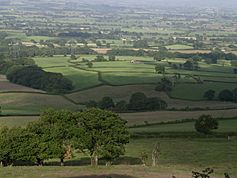
 Marshwood Vale viewed from Coney's Castle |
|
| OS grid reference | SY410980 |
| Unitary authority |
|
| Shire county | |
| Region | |
| Country | England |
| Sovereign state | United Kingdom |
| Post town | Bridport |
| Postcode district | DT6 |
| Police | Dorset |
| Fire | Dorset |
| Ambulance | South Western |
| EU Parliament | South West England |
| UK Parliament |
|
The Marshwood Vale is a beautiful, low-lying valley in the western part of Dorset, a county in south-west England. It's shaped like a bowl and is mostly made of a type of clay called Lower Lias clay.
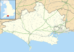
You can find it north of the A35 road, between the towns of Bridport and Lyme Regis. To its south are two of Dorset's tallest hills: Lewesdon Hill (279 meters high) and Pilsdon Pen (277 meters high). The River Char flows through the vale, heading south-west to the English Channel coast at Charmouth. The entire Marshwood Vale is part of the Dorset Area of Outstanding Natural Beauty, which means it's a special place protected for its natural beauty.
Exploring the Vale's Landscape
The Marshwood Vale is mostly farmland with a natural, wild feel. You'll find narrow roads winding between farms, small fields, old hedgerows, and small groups of trees. There are also ancient woods that have been there for a very long time.
The vale is almost completely surrounded by hills. These include Lewesdon Hill, which is the highest point in Dorset. There's also Pilsdon Pen, the second highest hill, which has an ancient Iron Age hill fort on top. Another hill, Lambert's Castle Hill, also has an Iron Age hill fort and offers amazing views across the vale.
Because the vale has not been heavily plowed or developed for large-scale farming, it's still home to lots of different plants and animals. This makes it a great place for wildlife to thrive.
A Look at the Vale's History
People have been farming in the Marshwood Vale since at least the Iron Age, which was thousands of years ago. Early farmers raised animals like sheep and cattle. They also grew crops such as barley and peas.
During the Middle Ages, farming grew even more, and people cleared more forests. Many farms in the vale have names ending in '-hay', which means 'enclosure'. These names come from the forest clearing that happened back then. The vale's many small, unevenly shaped fields also date back to this time. In the 13th century, Marshwood Castle was built. Today, only the earthworks of this old motte and bailey castle remain.
For a long time, the vale was known for being hard to travel through when it rained. This was because of its clay soil, which doesn't drain water well. In 1906, a writer named Sir Frederick Treves described it as "marshy and full of trees." An old Dorset historian, John Hutchins, said it "was hardly passable by travellers but in dry summers."
Even in the early 1900s, after long winter rains, some small farms were cut off and felt very lonely. Modern water pipes and electricity didn't reach the vale until the second half of the 20th century. Even in the 1960s, some farmers were still using horses to plow their fields!
Villages and Settlements
Today, several small villages and hamlets are located around the Marshwood Vale. These include Fishpond Bottom, Marshwood, Birdsmoorgate, Bettiscombe, Pilsdon, Bowood, Broadoak, Ryall, and Whitchurch Canonicorum. Most of these places are built on the hills and higher ground that surround the vale. The clay soil on the valley floor made it harder to build houses, so you'll only find a few scattered farms there.
Whitchurch Canonicorum is the largest village connected to the vale. It's famous for its church, St. Candida and Holy Cross. This church is special because it holds the actual remains of its saint, St. Wite. Long ago, pilgrims (religious travelers) would visit this shrine. They would stop at a 13th-century inn nearby to rest. Folklore says this is why the inn became known as the "Shave Cross Inn," because of the shaved heads of the pious guests.
The village of Marshwood shares its name with the vale. It sits on the hills to the north. From the churchyard, you can see the entire vale stretching out to the south. Beyond that, you can even spot the coastal hills and the English Channel.
 | Selma Burke |
 | Pauline Powell Burns |
 | Frederick J. Brown |
 | Robert Blackburn |


