Badbury Rings facts for kids

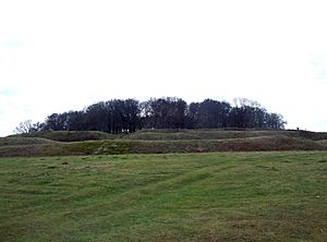
Badbury Rings viewed from the northeast
|
|
| Location | Shapwick, Dorset |
|---|---|
| Coordinates | 50°49′35″N 2°03′05″W / 50.8263°N 2.0515°W |
| Type | Hillfort |
| History | |
| Periods | Iron Age |
| Site notes | |
| Ownership | National Trust |
| Public access | Yes |
Badbury Rings is an ancient hill fort from the British Iron Age in east Dorset, England. It was once part of the land belonging to the Durotriges tribe. Later, during the Roman times, a temple stood just west of the fort. A Roman-British town called Vindocladia was also nearby to the southwest.
Contents
Exploring Badbury Rings: An Iron Age Hillfort
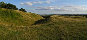
Badbury Rings is located 327 feet (100 m) above sea level. This impressive site was built in two main stages. The first part covered about 7.3 hectares (18 acres) and was protected by several ditches. The second stage was much larger, covering over 16.6 ha (41 acres), and had a single ditch and rampart for defense. Nearby, you can also find Bronze Age burial mounds called barrows, showing people used this area even earlier.
For a long time, Badbury Rings was privately owned. This meant that exploring the site was difficult. However, since 1983, the National Trust has owned the site, allowing more research. In 1993, the RCHME began surveying the hillfort. They cleared away plants and trees, which helped them complete their survey in 1998. This survey found 28 possible spots where huts might have been inside the fort's walls.
The first excavations, or digs, happened in 2004. Archaeologists dug three small trenches to see what they could find. Most of the pottery they uncovered was from the Late British Iron Age. It seems Badbury Rings was not a main settlement in the Early Iron Age. The hillfort might have become less populated later in the Iron Age. This could be because the Roman town of Vindocladia, near Shapwick, started to grow.
Badbury Rings is one of several important Iron Age earthworks in the area. It is part of a chain that includes Hambledon Hill, Hod Hill, Spetisbury Rings, Buzbury Rings, and Dudsbury Camp. The ancient port at Hengistbury Head is also part of this group of Iron Age sites.
Roman Roads and Connections
During the Roman period, five Roman roads met in a complex network on the north side of Badbury Rings. These roads were like ancient highways, connecting different parts of the Roman Empire.

The Roman conquest of Britain started in AD 43. It is thought that a Roman army, the Legio II Augusta, fought in Dorset. This army was led by Vespasian, who later became an emperor. About 4 km (2+1⁄2 mi) southeast of Badbury Rings, near Wimborne, the Romans built a fort. A military road was built from this fort, passing by the northeast side of Badbury Rings.
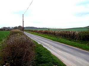
Beyond Badbury Rings, this road went northwest towards the Roman fort at Hod Hill. You can still see it today as a thin line of trees. This road also connected with Ackling Dyke, another Roman road that went northeast to Old Sarum (called Sorviodunum by the Romans). Another road crossed the countryside northwest towards Bath (Aquae Sulis). A fourth road went south to a small port in Poole Harbour (Moriconium, now Hamworthy). The last road, still used as a track today, went southwest through the settlement of Vindocladia towards Dorchester (Durnovaria). This last road was built later in the Roman period.
The Roman Temple at Badbury Rings
Just west of Badbury Rings, there is a site where a Romano-Celtic temple once stood. This type of temple mixed Roman and Celtic building styles. You can see its polygonal boundary on aerial photos.
Archaeologists first dug here in 1900 and again in 1952. They found stone roof tiles, pieces of painted wall plaster, and over 185 Roman coins. They also found 21 silver and bronze coins from the local Durotriges tribe. Other finds included pottery, glass beads, bronze pins, a bracelet, and a brooch. More excavations in 2000 showed that the temple was used for a long time, from the 1st to the 5th centuries AD.
Vindocladia: A Roman-British Town
A short distance (1.5 km, 1 mi) southwest of Badbury Rings, between the hillfort and the village of Shapwick, was a small Roman-British town. It is believed to be Vindocladia, a place mentioned in an ancient Roman travel guide called the Antonine Itinerary. Its name likely comes from old British words meaning "white ditch" or "white earthwork." Later in the Roman period, a small fort was also built on the east side of this town. The fort was only discovered in 1975, and the town itself became known in the 1990s.
People have known about Roman activity in this area for a long time. In 1954, Roman items were found in Shapwick, including pottery, a bronze coin, and a piece of a Roman bowl. In 1990, a survey found three areas with building remains, such as roof tiles and small mosaic pieces. These finds also included pottery from the 2nd to 4th centuries.
Excavations led by Martin Papworth took place in 1991, 1995, and 2004. The 1991 digs found evidence of ironworking. The 1995 digs showed that the Roman settlement was built over older Iron Age pits and ditches. They also found smithing hearths from the second century. These digs also revealed that the Roman road through the settlement and the fort were built later in the Roman period. In 2004, digging in the settlement's boundary ditch uncovered pottery and a brooch from the early first century.
The evidence suggests that Vindocladia started as a village or town in the late Iron Age before the Romans arrived. It continued to be used during the Roman period. Coins and pottery found show that people lived there until at least the 5th century. A special survey of the entire settlement shows it covered 25 hectares. This makes it one of the largest Roman towns in Dorset, second only to Dorchester (Durnovaria). It is likely that this town was the Vindocladia mentioned in the Antonine Itinerary.
The Roman fort at Vindocladia was a rectangular area with rounded corners, surrounded by three ditches. It measured about 200 m × 160 m (220 yd × 170 yd) and covered about 2.5 ha (6 acres). It was located on the east side of the town. Pottery found in 1975 suggested the fort was built in the mid-1st century. However, later excavations showed it was built later in the Roman period and stopped being used at the end of the Roman era. The fort had a large building complex, which might have been a Roman inn, or mansio.
Badbury Rings in the Saxon Era
Finds of late Roman items inside the hillfort suggest that Badbury Rings was used again after the Roman period. This might have happened as safety decreased in post-Roman Britain. An old border defense called Bokerley Dyke was brought back into use. It may have helped keep the invading Saxons out of Dorset during the 5th and 6th centuries.
Some historians in the 19th century suggested that Badbury Rings might be the site of the famous Battle of Mount Badon. This battle was first mentioned by an ancient writer named Gildas. Local historian Roy Carr has suggested that the Saxons were stopped from crossing Bokerley Dyke because of an army in the west, possibly stationed at Badbury Rings. Badbury Rings is one of a few places thought to be the site of this important battle, with the city of Bath also being a possibility.
Later, in 899, Edward the Elder brought an army to Badbury. He came to face a challenge from his cousin Æthelwold, who was based nearby in Wimborne Minster.
Old Stories About Badbury Rings
The Tudor historian John Leland visited Badbury Rings between 1538 and 1543. After talking about Wimborne Minster, he wrote:
The Saxon Kinges had hard by the Toune a Castelle now caullid Badbyri, but clerely down. The Diches, Hilles, and Site ther of be yet evidently seene. now Conyes borough in it.
This means he saw the old ditches and hills of the castle, which was then ruined, and rabbits were living in it.
Badbury Rings Today
Today, Badbury Rings is part of the Kingston Lacy estate. The National Trust has owned it since 1982, and visitors can explore it freely. On a clear day, you can even see the Isle of Wight from the top of the hillfort.
Images for kids
 | John T. Biggers |
 | Thomas Blackshear |
 | Mark Bradford |
 | Beverly Buchanan |


