Hengistbury Head facts for kids
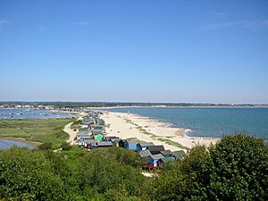
View from Warren Hill overlooking Mudeford Spit
|
|
| Location | near Christchurch |
|---|---|
| Region | Dorset, England |
| Coordinates | 50°42′57″N 1°45′14″W / 50.71583°N 1.75389°W |
| Type | Ancient Monument, Local Nature Reserve, SSSI |
| History | |
| Periods | Stone Age, Bronze Age and Iron Age |
| Site notes | |
| Condition | Well preserved |
Hengistbury Head is a special piece of land that sticks out into the English Channel. You can find it between Bournemouth and Mudeford in Dorset, England. It's super important for its history and nature.
This area is officially an Ancient Monument. This means it's protected because of its old history. In 1990, it became a Local Nature Reserve. It's also part of the Christchurch Harbour Site of Special Scientific Interest. This shows how special its wildlife and plants are.
People have lived and visited Hengistbury Head for a very long time. We know this from the Stone Age. Later, in the Victorian era, people dug up a lot of stone here. Today, many tourists visit, over a million every year! The Head is home to many plants, birds, and insects. Some of these are very rare. The land is slowly wearing away from the sea, but people are working to protect it for the future.
Contents
Exploring Hengistbury Head's Location
Hengistbury Head is a sandstone headland. It's connected to Southbourne, a part of Bournemouth to the west. The closest big town is Christchurch to the north. This headland is the most eastern point of Poole Bay.
Long ago, it was part of Hampshire. But in 1974, it became part of Dorset. The northern side of the hill slopes down to form Mudeford Spit. This sandy bar helps close off Christchurch Harbour from the sea.
Buildings and Beach Huts
The sandy spit is famous for its more than 300 privately owned beach huts. These huts are some of the most expensive in the UK. In 2015, five huts were for sale for a total of £1 million!
These huts are small, about five by three metres. They don't have running water. People can only stay overnight from March to October. Even with few comforts, this area is very popular. Huts can rent for up to £600 a week.
The Black House is a well-known building at the end of the spit. It faces Mudeford Quay, where the Battle of Mudeford happened in 1784. The Black House was built in 1848. It was once a boat-builder's home. Now, people can rent it for holidays. Many stories link it to smugglers, but these stories are likely not true.
What's in a Name?
Hengistbury Head has had different names over time. In the early 1100s, it was called Hednesburia. In the 1600s, it was Hynesbury Head. The name "Hengistbury" only appeared in the 1800s.
At that time, people liked to connect old places with famous historical figures. They thought the legendary Anglo-Saxon leader Hengist might be buried here. He was said to be buried in a special mound. However, later digs showed that the burial mounds at Hengistbury Head are from the Bronze Age, much older than Hengist.
A Look at History
Hengistbury Head is full of amazing archaeological sites. These sites show human activity from the late Stone Age all the way to the Roman times. This is why it's a Scheduled Ancient Monument.
Interest in the site slowed down during the Dark Ages. But around 890 AD, Christchurch grew a lot. Hengistbury Head might have been used as a lookout point then. In the Victorian period, a lot of stone was dug up here. Today, over a million people visit each year.
Stone Age Discoveries
Archaeologists have found proof that people lived here during the Stone Age. An old settlement was found on the hill, dating back about 14,100 years. Over 13,000 stone tools were found, making it one of the largest sites from that time.
Many of these tools were blades, which are rare to find outside of caves in the UK. People at the Head were very good at making these blades. Tools like backed blades, scrapers, and burins were common.
Back then, Warren Hill would have overlooked a large river valley. This valley later became the English Channel. After the sea covered the valley, Mesolithic hunter-gatherers used the site. Studies of old plant pollen show the headland was lightly wooded. This was perfect for hunting animals.
Bronze Age Importance
During the Bronze Age Britain, Hengistbury Head was an important seaport. There are eleven Bronze Age Britain round barrows (burial mounds) on the headland. Two more are a bit further inland. Archaeologists dug up eleven of these mounds. They found axes and cremation urns from the Early Bronze Age. These items are between 3500 and 4000 years old.
One special mound held the remains of a young woman. She was buried with an incense cup, an amber and copper pendant, and two gold cones. These items are similar to those found with the Wessex culture. An urn found here was made around 1700 to 1500 B.C. It was Trevisker ware, a type of pottery found mostly in Devon and Cornwall. This shows trade happened over long distances.
Iron Age Fortification and Trade
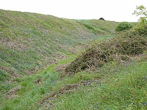
Around 700 BC, during the Iron Age Britain, a settlement was built on the Head. To protect it, two large banks and ditches were built. These are called the Double Dykes. They are similar to defenses found at places like Maiden Castle.
The inner bank was three metres high with a ditch three and a half metres deep. The outer ditch was six metres wide and two metres deep. These defenses turned Hengistbury Head into a strong, fortified settlement. It grew into a very important port.
People here also worked with metals. Small iron-ore smelting hearths were found on Warren Hill. Archaeologists also found evidence of working with lead, copper, and silver. Two ingots (blocks of raw metal) were discovered. One was pure copper, and the other was a mix of copper and silver with a little gold. This shows that raw materials were brought here. They even refined silver from copper. Gold was also worked here, as shown by a piece of a torc (a twisted metal necklace) and a touchstone used for testing gold.
Thousands of bronze coins from before the Roman period have been found. Most were made by the Durotriges tribe. The large number of coins and metalworking tools suggests that these coins were made right here.
A Hub for International Trade
Because of its advanced metalworking and easy access from Europe, Hengistbury Head became a major port in the Late Iron Age. People traded iron, silver, and bronze items. In return, they got things like figs, glass, and tools.
Coins and pottery from Armorica (modern-day Brittany) show trade links. Many amphorae (large jars) used for Italian wine have been found here. More have been found here than at all other sites in southern England combined! This means Hengistbury Head was a main entry point for wine into Britain. However, no similar jars were found in Armorica. This suggests a direct trade route between Hengistbury Head and Italy. Most of these jars are from before 50 B.C. Later styles are missing, meaning the wine trade likely slowed down when Caesar started his wars in Gaul.
From Roman Times to the Middle Ages
After the Romans took over Britain, the southeast of England became more urban. But the southwest, including Hengistbury, changed less. Hengistbury still served as an important hub for tribes like the Dumnonii and Durotriges. Water transport was best then. The Head offered coastal routes and river access via the Stour and Avon rivers.
There is no sign that Saxons used the Head. The area wasn't settled much again until Alfred the Great rebuilt the harbour around 890 AD. He wanted to defend against raiders. He built the town of Christchurch on the north side of the harbour. This was a good spot because of access to Salisbury up the River Avon. The Head might have been used for harbor defense. In the 11th century, some iron-rich stones from the Head were used to build Christchurch Castle. You can still see these reddish stones at the base of the ruined castle.
17th, 18th, and 19th Centuries
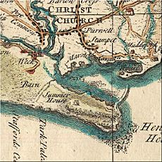
In the late 1600s, Andrew Yarranton tried to improve the harbour. In 1693, a channel was cut to the sea. Ironstone boulders from the Head were used to build a pier. But the plans didn't work well. Storms, like the Great Storm of 1703, soon destroyed most of the work. Parts of the pier, called "Clarendon's Jetty" or "Long Rocks," are still visible. Many tons of stone might have been taken from the beach and the Head for this jetty.
In 1733, new taxes were put on many imported luxury items. Christchurch quickly became a place for smugglers, who called themselves "freetraders." Many people in the town were involved. The "Double Dykes" were supposedly used to hide illegal goods. Mudeford spit was rumored to be where "Guinea boats" were built. These were cheap galleys that could sometimes outrun steamships. One story says the Black House became black when customs officers tried to smoke out smugglers by lighting fires around it. But the house was built in 1848, when smuggling was already declining. So, it probably wasn't used much for smuggling. The spit has a long history with shipbuilding, with two large ships built in the mid-1800s.
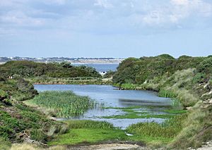
From 1848 to 1872, the Hengistbury Mining Company dug up many more ironstone boulders. These boulders, called Iron Doggers, were valued for their high iron content (up to 30%). They form the base of Hengistbury Head. Removing so many doggers weakened the headland. This digging, along with earlier ones, caused up to a third of the Head to be lost, mainly due to erosion. The silt washed down also harmed the saltmarsh below. A dam was built in 1976 to create a pool and reduce this problem. Many "doggers" can still be seen along the land-train route and at the quarry.
Britain's First Airshow
In 1910, Britain's first international aviation meeting took place here. It was held on a special aerodrome (airfield) between the "Double Dykes" and Tuckton village. About twenty early aviators from around the world competed. They did things like spot landing, altitude tests, and speed races.
On the second day, Charles Rolls, who helped start Rolls-Royce, was in an accident. His plane broke apart, and he fell. He died from his injuries soon after. This was Britain's first fatal flying accident involving a powered aircraft.
20th Century Changes
There were many plans for Hengistbury Head. In 1885, a big railway and docks were suggested. Before World War I, proposals for housing and a golf course came up. But none of these plans happened. In 1919, Sir George Meyrick sold the Head to Harry Gordon Selfridge, who wanted to build a grand house. These plans also failed, except for a nursery garden.
Bournemouth Borough Council bought the Head in 1930 for £25,200. They planned for housing west of the Double Dykes, but the Head itself was to be kept as public open space. During World War II, the Head was closed to the public. The army used it for things like a radar station. The area was also heavily mined. The military defenses were finally removed by the 1950s.
Hengistbury Head Today
Today, BCP Council owns and manages Hengistbury Head Local Nature Reserve. In 1990, it became a Local Nature Reserve. This showed Bournemouth's promise to protect the environment. The heathland is part of the Dorset Heaths. It is protected internationally as a Special Area of Conservation and Special Protection Area. The nearby Christchurch Harbour is also an Environmentally Sensitive Area.
People use the Head for many reasons today. It's a popular tourist spot for walks on its gravel paths. Some paths were improved in 2008, making them more wheelchair accessible. For example, you can now reach Quarry Pool in a wheelchair. Students often visit for field trips. There are also guided tours and meetings about the Head's nature and history.
There's a cafe at the bottom of the Head on the Bournemouth side. The Hengistbury Head Outdoor Education Centre is nearby. It offers water and outdoor activities. A fun land train (called "the Noddy train") takes people from the cafe to the end of the spit. This ride takes about ten minutes. On the Head itself, there's a H. M. Coastguard radio station, a nature reserve, and a triangulation pillar. This pillar is shown on Ordnance Survey maps as 36 metres above sea level. You can find plenty of parking near the cafe. The Head is also easy to walk to from Southbourne and parts of Christchurch.
The Quarry Pool is now a key part of the nature reserve. It used to be very acidic. But since 1990, many plants and insects have grown there. Birds like mallards and little grebes also live there. The insects provide food for migrating sand martins and swallows.
The Visitor Centre
A new visitor centre for Hengistbury Head opened in December 2013. The old thatched barn was updated in an eco-friendly way. The new part cost over a million pounds. Money came from developer contributions, the Heritage Lottery Fund, and landfill tax.
The centre has displays about the site's archaeology, nature, and geology. There's also space for volunteers and community groups. Visitors can see some of the items found at Hengistbury Head. They can also talk to staff and get involved in managing the nature reserve.
The area around the centre has been made into outdoor learning spaces and a wildlife garden. It has energy-saving features like solar panels for electricity. It also uses a ground source heat pump for heating. A green roof helps absorb rain and insulate the building. The centre's walls are made with timber frames and straw bales for insulation.
Understanding the Geography
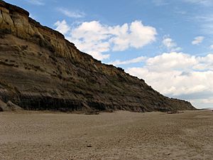
Hengistbury Head is a great place to study geology. It has unusual nodules of sideritic ironstone in its Middle Eocene layers. The exposed cliff face is perfect for studying stratigraphy (rock layers). Warren Hill is made of Tertiary Bracklesham Beds. These are clays and marls with sandy and lignitic layers on top.
Erosion and Protection
One big threat to Hengistbury Head is erosion. The southern cliff face is worn away by wind, rain, and the sea. This is mainly due to Longshore drift. Maps show that 25 metres of cliff were lost between 1915 and 1962. This process sped up because of concrete promenades and groynes built in Bournemouth. It's thought that about 150 metres of land have been lost from the Head in the last 200 years.
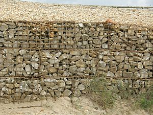
The first effort to stop erosion was in the 1930s. Bournemouth Council built a breakwater called "the Long Groyne." Since then, a gabion revetment (a sloped structure of rocks in cages) was built. This protects the weakest part at the eastern end of the Head. From 2005 to 2008, Poole Bay was refilled with 1.8 million cubic metres of sand and shingle. This project aimed to secure the Head's future. It created wider beaches, which help protect the coast and are enjoyed by visitors.
Amazing Plants and Animals
Hengistbury Head is part of the Christchurch Harbour Site of Special Scientific Interest (SSSI). In May 1990, it became a Local Nature Reserve. The Head has 500 plant species, which is a quarter of all plants in the UK! This includes eight red data book species (very rare ones).
The main nature reserve faces Christchurch Harbour. It connects to the reed beds of Wick Fields. The Head has many different habitats. These include heathland on Warren Hill, freshwater ponds, sand dunes, and salt marshes. The woodland (called Withybed Wood) has English oak and silver birch trees. This woodland is special because it's the only one shown on an 1811 map of the area. In 2002, cattle started grazing in a field near the visitor centre. This, along with removing gorse, has helped restore the habitat to its old character.
A very rare plant called sea knotgrass (Polygonum maritimum) grows here. It's listed as a "schedule 8 species." This means it's highly protected from harm. The heathland is also a Special Area of Conservation and a Special Protection Area. These are part of a network of Europe's best wildlife sites.
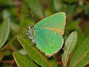
The different habitats are home to many insects. Over 700 moth species have been recorded here, a quarter of the UK's total. You can see butterflies like the green hairstreak. You can also spot damselflies (like the large red damselfly) and dragonflies (like the hairy dragonfly). In 2005, the very rare thirteen-spotted ladybird was seen here. It was the first sighting in the UK since 1952!
More than 300 bird species have been recorded, making Hengistbury Head an important stop for migrating birds. The Balearic shearwater, which is critically endangered, has been seen here. Other rare birds include the purple heron, the pink-footed goose, and the European honey buzzard. In summer, you can hear and watch many skylarks in the fields near the car park.
Natterjack Toad: A Success Story
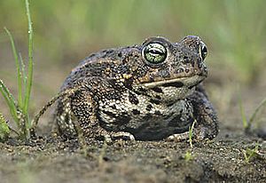
In 1989, a project began to bring back the UK's rarest amphibian, the natterjack toad, to Hengistbury Head. The natterjack toad was last seen here in the 1950s. It likely disappeared because there weren't enough suitable ponds. The project has been a big success! Today, there are many thriving populations of natterjack toads in different spots. The best time to see their mating rituals is in May, as dusk arrives. You can hear their unique call from far away.
Local Politics
Hengistbury Head is part of the Bournemouth East parliamentary constituency. This means people living here vote for a Member of Parliament (MP) to represent them in the UK Parliament. Hengistbury Head is also part of the East Southbourne and Tuckton ward. This ward elects two councillors to the Bournemouth, Christchurch and Poole Council. These councillors help make decisions for the local area.
 | Tommie Smith |
 | Simone Manuel |
 | Shani Davis |
 | Simone Biles |
 | Alice Coachman |


