
Christchurch Harbour facts for kids
| Site of Special Scientific Interest | |
 |
|
| Area of Search | Dorset |
|---|---|
| Interest | Biological Geological |
| Area | 352.1 hectares |
| Notification | 1986 |
| Location map | Magic Map |
| Christchurch Harbour | |
|---|---|

Christchurch Harbour
|
|
| OS grid reference | SZ174914 |
| District | |
| Shire county | |
| Region | |
| Country | England |
| Sovereign state | United Kingdom |
| Post town | CHRISTCHURCH |
| Postcode district | BH23 |
| Police | Dorset |
| Fire | Dorset |
| Ambulance | South Western |
| EU Parliament | South West England |
| UK Parliament |
|
Christchurch Harbour is a natural harbour in Dorset, on the south coast of England. It's named after the nearby town of Christchurch.
Two rivers, the Avon and the Stour, flow into the harbour. The water here is usually shallow. It also has a special "double high water" tide because of how the English Channel works.
On the north side, you'll find Priory Marsh and Stanpit Marsh. Stanpit Marsh is a special Local Nature Reserve. On the west side are Wick Fields. The south side is bordered by Hengistbury Head, a well-known coastal area.
The harbour connects to Christchurch Bay and the English Channel through a narrow channel called The Run. This channel is between Mudeford Quay and Mudeford Spit. Smaller boats can enter here and travel about 2 miles (3.2 km) upstream. They can go up the Avon or the Stour, with the Stour leading to Iford Bridge, past Christchurch Quay and Tuckton.
Christchurch Harbour is also a Site of Special Scientific Interest (SSSI). This means it's a very important area for both its wildlife and its geology. It covers about 352 hectares (870 acres). It includes the rivers' estuaries and the Hengistbury Head peninsula. The area has many different habitats like saltmarsh, wet meadows, grasslands, and woodlands. It's especially important for birds.
Contents
History of Christchurch Harbour
How the Harbour Was Formed
Christchurch Harbour was created about 7,000 years ago. This happened when sea levels rose after the last Ice Age ended. Before that, the area was far from the sea. Stone Age hunters lived there. Tools from 12,500 years ago have been found at Hengistbury Head. Even older flint tools, from 250,000 years ago, were found nearby.
Some people think the Bluestones used for Stonehenge might have been moved through the harbour. This would have been around 2550 BCE. There might have been an old path, usable at low tide, from Hengistbury Head to Stanpit.
Ancient Trade and Roman Times
Around 100 BCE, the harbour became a busy trading port. People exported things like copper, gold, silver, and iron. They imported luxury items like wine and glass, which were used to make jewelry. It's also likely that slaves were traded here.
The boats used were shallow and made of oak planks. They had square leather sails. A trip across the channel to Cherbourg would take about twelve hours. This was very difficult without modern compasses or weather forecasts! Even so, there was a lot of trade with both British and foreign ports.
Trade slowed down after the Romans invaded France in 56 BCE. The remains of a Roman ship were found in the harbour in 1910. Trade stopped completely when the Romans invaded Britain in 43 AD.
Saxon Era and Later Changes
During Saxon times, the harbour became important again. It was easy to reach from Europe. Boats could travel up the River Avon to Salisbury. They could also go along the Stour to Wimborne and Blandford Forum.
In 1664, a law was passed to allow boats to travel to Salisbury again. This was to make it a port like in medieval times. Boats used the river from 1684 to 1720. The route was finally stopped in 1730.
In 1695, Lord Clarendon tried to make a new entrance at Mudeford Sandbank. He used iron stone from Hengistbury Head to build a bank. These rocks are still there and are called Clarendon Rocks. But the new entrance soon filled with sand, and the channel went back to its original path.
During this time, and until the mid-1800s, smuggling was very common in the harbour. You can read about the famous Battle of Mudeford.
Modern Developments
Many plans were made to improve the harbour over the next three centuries. One big plan in 1885 was for a railway and docks. This would have involved a lot of dredging and a railway station on the south side. In 1965, there were plans for a marina at Wick Hams. None of these big plans ever happened.
In the 1930s, there were three "tea boats" that served drinks to holidaymakers. There were also at least five houseboats in the harbour. All of these were left and then destroyed during World War II.
The river was dredged (cleaned out) in 1937 and again in the 1950s. In the late 1980s, Wessex Water did a lot of dredging in the River Stour. This was part of a plan to prevent floods.
The channel has been marked for boats since at least 1884. The Mudeford inshore lifeboat has been at Mudeford Quay since 1963.
Geology of the Harbour
The harbour floor is made up of different types of sand and mud. There are both high and low Salt marsh areas. The low marsh has special grasses. The plant Spartina anglica is not very common here. This means the harbour's sand and mud haven't changed much because of this plant, unlike other estuaries. Any lost salt marsh has been replaced by plants growing in old artificial salt pans.
Large areas of Phragmites reed beds grow along the edges of tidal creeks. They also grow in higher marsh areas, in front of wet grazing meadows. The harbour system collects more sand and mud than it loses. Grimbury Marsh is mostly made of material that was dredged (removed) from the harbour. Overall, the estuary is a place where sediment builds up.
The Royalty Fishery
The first mention of a Royal Fishery in Christchurch is from 939 AD. It was a very valuable fishing area in medieval times. The fishing rights were given by a Royal Grant during Queen Mary's reign. They were renewed by Elizabeth I. The Crown owned the rights because of treason.
The Queen later sold the rights back to Lord Huntington. In 1791, they were sold to the Lord of the Manor of Christchurch. The fishery was then sold to Mr. Thyrwit Walker in 1865. In 1929, West Hampshire Water Company bought it. The Crown kept the rights to the bottom third of the fishery. This was probably to help stop smuggling.
Today, this fishery is said to be the best place in England for Sea trout fishing. You can also find Salmon, Mullet, and Bass here. Other fish include Coarse fish, Roach, Dace, Carp, and Pike. The harbour and rivers are now a sport fishery. This means all fish caught must be returned to the water. This helps make sure there are enough fish for the future.
Wildlife in the Harbour
Christchurch Harbour is home to many different animals and plants. The Christchurch Harbour Ornithological Group has recorded over 320 bird species here. The harbour and marshes are a very important stopping point for birds that migrate (travel long distances).
There are also many insects and rare plant species. Stanpit Marsh and other marshes are used for grazing horses and cattle. Both Otters and Seals have been seen in the harbour.
Leisure Activities
The harbour is a popular place for fun activities. There are three sailing clubs: Highcliffe Sailing Club, Mudeford Sailing Club, and Christchurch Sailing Club. Christchurch Rowing Club is located on The Quomps. The Hengistbury Head Activities Centre is on the south side of the harbour.
There are over 1,400 places for small boats to moor in the harbour and rivers. People enjoy Sailing, rowing, canoeing, windsurfing, and kite surfing. Fishing, walking, and bird spotting are also popular activities along the harbour shores.
Ferries run from Tuckton Bridge to Mudeford Sandbank. Another ferry goes between Mudeford Sandbank and Mudeford Quay. Some of these ferry boats have been used since the 1930s! The Mudeford ferry crossing, called "The Run," used to be done by rowing boats until the 1960s. Passengers paid what they thought was fair. There is also a ferry at Wick.
Exploring Around the Harbour
To help describe the harbour, we can divide it into sections. We'll start from the inland (west) side and move towards the sea outlet (east end). Tuckton Bridge over the River Stour is a good starting point. This bridge also marks the boundary between Bournemouth and Christchurch.
North Side Features
From Tuckton Bridge along the River Stour, you'll see riverfront houses. These go up to the Captains Club hotel. This hotel is at the west end of a quay and open space called The Quomps. Christchurch Priory overlooks this area from the east. The River Avon joins the Stour next to the Priory.
Across the Avon are Priory and Grimbury Marsh. Then comes the larger Stanpit Marsh. Blackberry Point is an island at high tide, located east of the marsh. Further east are the towns of Stanpit and Mudeford. At the very eastern end of the harbour is Mudeford Quay. The harbour entrance, a narrow channel called The Run, is also here. The coast eastward from here, open to the sea, leads to Highcliffe.
South Side Features
From Tuckton Bridge, the two main parts of the harbour shore are Wick and Hengistbury Head. These areas are in Southbourne, a suburb of Bournemouth. The main part of the harbour starts around Wick Fields. This is a reed marsh and an important area for nature.
The Hengistbury Head Activities Centre is on the shore just before Barn Bight. In the 1800s, Hengistbury Head was threatened by the mining of ironstone. This caused a lot of erosion. To stop the silt from washing into the harbour, the Quarry Pool was created in 1976 by building a dam.
Holloway's Dock cuts into the land before the shore reaches Mudeford Sandbank. This sandbank stretches north towards The Run. The sandbank is famous for its many Beach huts, a cafe, and the station for the Hengistbury Head Land Train.
Stanpit Marsh Nature Reserve
Stanpit Marsh is located along part of the southwest side of the Stanpit road. It was formed by the action of the rivers Stour and Avon as they meet the saltwater in Christchurch Harbour.
Together with Grimbury Marsh, it forms one of the largest salt marsh areas in the county. It is a Site of Special Scientific Interest (SSSI). It's also an important nature reserve of about 65 hectares (160 acres). It has both freshwater and saltwater habitats. It's a key stopping point for birds that migrate. A walking path on the marsh crosses Mother Siller's Channel using a special bridge. The highest point of the marsh is Crouch Hill, which is 15 feet (4.6 m) above sea level.
Images for kids
-
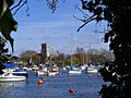
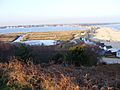
Christchurch Priory from Wick, across the River Stour
-
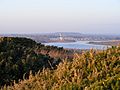
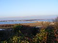
Christchurch from Hengistbury Head, across the harbour
-
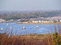
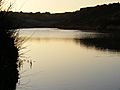
Sand bar and outlet of Christchurch Harbour
-
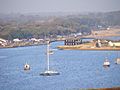
Detail of outlet of Christchurch Harbour
-
Sand bar at end of Christchurch Harbour, viewed from Hengistbury Head
-
Sand bar at end of Christchurch Harbour, viewed from Hengistbury Head
-
The Quarry Pool, Hengistbury Head
-
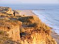
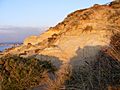
South-eastern cliff of Hengistbury Head
-
Hengistbury Head, cliff face on western end of Warren Hill.


