
Beaulieu River facts for kids
Quick facts for kids Beaulieu River |
|
|---|---|

The Beaulieu River at Longwater Lawn, near Lyndhurst
|
|
| Country | England |
| Region | Hampshire |
| District | New Forest |
| Physical characteristics | |
| Main source | Lyndhurst, Hampshire 50°52′47″N 1°34′55″W / 50.879746°N 1.582054°W |
| River mouth | Needs Ore Point, Hampshire 50°46′16″N 1°23′30″W / 50.770997°N 1.391578°W |
| Length | 20 km (12 mi) |
| Basin features | |
| Tributaries |
|
The Beaulieu River (BEW-lee) is a small but important river in southern England. It flows through the beautiful New Forest area in Hampshire. This river is about 20 km (12 mi) long.
What makes the Beaulieu River special is that it's privately owned. The river, including its bed, belongs to Lord Montagu of Beaulieu. This is quite unusual for a river in England!
Contents
What's in a Name?
The Meaning of Beaulieu
The river's current name, Beaulieu, comes from the French words "beau lieu." This means "beautiful place." It's a very fitting name for such a lovely river.
The Original Name: River Exe
Long ago, the river was known as the River Exe. This older name comes from an ancient British word, Iska. Iska meant "fishes" or "fish-place." You can find similar river names like River Axe or River Usk in Britain. This shows how names can change over many centuries.
Where the River Flows
Starting Point
The Beaulieu River begins near Lyndhurst. This area is right in the middle of the New Forest. Here, the river starts as many tiny streams. These small streams join together to form the main river.
Journey Through the Forest
The river flows southeast and then south through the open lands of the New Forest. It passes through pretty areas with scattered trees and heathland. Eventually, it reaches the charming village of Beaulieu.
Tidal Waters and History
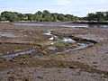
When the river reaches Beaulieu village, it becomes a tidal river. This means the water level rises and falls with the ocean tides. In the past, the river's tides powered a tide mill in the village. This mill stopped working in 1942.
Further downstream, the tidal part of the river continues south-east. It flows past the small village of Buckler's Hard. The river then enters The Solent, which is a strait of the English Channel. Near its mouth, a raised salt marsh called Gull Island separates the river from The Solent.
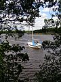
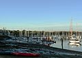
Below Beaulieu village, the river is deep enough for small boats to sail on. Buckler's Hard was once a very important place for building ships. Many wooden sailing ships were built there, including warships for the navy. One famous ship built there was HMS Agamemnon, which was used by Nelson.
Since the year 2000, a special lighthouse helps guide boats into the river. It's called the Millennium Lighthouse or the Beaulieu River Beacon.
River Branches
The Beaulieu River has two main smaller rivers that flow into it. These are called tributaries.
- The Beaulieu Abbey Stream joins the river from the left side.
- The Hatchet Stream joins the river from the right side.
There are also some man-made lakes near the river's mouth. These are known as the Black Lagoons.
On Screen
The Beaulieu River has even been in a movie! In 1966, some scenes for the film A Man for All Seasons were filmed here. The river's tree-lined banks were used to look like the River Thames in the 16th century.
Gallery
-
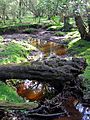
The infant river upstream from Dunces Arch
-
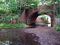
The river passes beneath the railway, north of Fulliford Passage
-
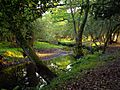
Bend in the river near Pottern Ford
-
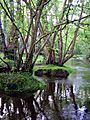
Alder trees in the river north of Fawley Ford
-

The Mill Dam at Beaulieu
-
The upper tidal limit of the river
-
The river between Beaulieu and Bucklers Hard
-
The river at Bucklers Hard
-

A yacht entering the river from the Solent
-
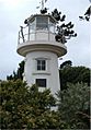
Millennium Lighthouse at the mouth of the river


.JPG)


