Upton, Dorset facts for kids
Quick facts for kids Upton |
|
|---|---|
 Shops at Upton |
|
| OS grid reference | SY978932 |
| Civil parish |
|
| Unitary authority |
|
| Ceremonial county | |
| Region | |
| Country | England |
| Sovereign state | United Kingdom |
| Post town | POOLE |
| Postcode district | BH16 |
| Dialling code | 01202 |
| Police | Dorset |
| Fire | Dorset |
| Ambulance | South Western |
| EU Parliament | South West England |
| UK Parliament |
|
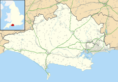
Upton is a town located in the south-east part of Dorset, England. It sits east of Holton Heath and Upton Heath, and north of Hamworthy, which is a suburb of Poole. Upton is the second largest town in the beautiful Purbeck Hills area.
Contents
Exploring Upton's Location
Upton is built around a busy road junction. Here, the road connecting Blandford to Hamworthy crosses the main road from Poole to Dorchester. To the south, you'll find the Poole areas of Hamworthy and Turlin Moor. The village of Lytchett Minster is also close by, just a short distance to the west.
Natural Surroundings of Upton
The town is surrounded by several open spaces. To the north, Upton Heath is a special area known as a Site of Special Scientific Interest (SSSI). This means it's protected because of its important wildlife and natural features. East of town, Upton Wood and the beautiful Upton Country Park separate Upton from Holes Bay. To the south, Lytchett Bay is part of the larger Poole Harbour SSSI.
Businesses and Landmarks in Upton
While Upton is mostly a place where people live, it also has a small area with businesses. One of these is Southernprint, a printing company.
In the year 2000, the Upton Clock Tower was built at the Upton Crossroads. This tower was created to celebrate the new millennium and show the town's pride. In 2015, a special care home for people with dementia opened at the Crossroads. This building also has a pharmacy and a coffee shop.
You can find more shops at Moorland Parade, located at the top of Moorland Way. This is also where the offices for the Lytchett Minster & Upton Town Council are.
Upton has two churches. The Wesleyan Chapel for Upton Methodist Church was built in 1865. The current St Dunstan's church and its Community Centre were approved in 1991, replacing an older church that stood on the same spot.
How Upton is Governed
Upton is part of the civil parish of Lytchett Minster and Upton. This parish is part of the Purbeck local government district within Dorset. For national elections, Upton is part of the Mid Dorset and North Poole area, which elects a Member of Parliament to the House of Commons.
Learning and Schools in Upton
Upton has two public schools: Upton Infant School and Upton Junior School. These schools prepare students to move on to Lytchett Minster School. There are also other schools in town, including The Yarrells Preparatory School and Ladybirds Playschool. Upton Methodists Pre-School is located at the Methodist church.
Getting Around Upton
Upton is located where two main roads, the A35 and the A350, meet. The town has several bus routes, including numbers 8, 9, 10, and 40 by Wilts & Dorset, and the X54 service by FirstGroup. These buses connect Upton to places like Hamworthy, Creekmoor, Poole, Wareham, Lytchett Matravers, Swanage, and Weymouth.
The closest train station is Hamworthy. From here, trains run twice an hour in both directions on the South West Main Line. This line connects London Waterloo to Weymouth. While a bit further away, Poole station offers more frequent train services.
 | Georgia Louise Harris Brown |
 | Julian Abele |
 | Norma Merrick Sklarek |
 | William Sidney Pittman |


