
River Riccal facts for kids
Quick facts for kids River Riccal |
|
|---|---|

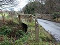
Footbridge over the river Riccal
54°18′3.38″N 1°3′28.26″W / 54.3009389°N 1.0578500°W |
|
| Country | England |
| Physical characteristics | |
| Main source | Confluence of Bonfield Gill and Bogmire Gill near Helmsley 130 metres (430 ft) 54°17′52″N 1°3′40″W / 54.29778°N 1.06111°W |
| River mouth | River Rye 24 metres (79 ft) 54°12′14″N 0°54′58″W / 54.20389°N 0.91611°W |
| Length | 18.36 kilometres (11.41 mi) |
| Basin features | |
| Basin size | 57.6 square kilometres (22.2 sq mi) |
The River Riccal is a cool river in North Yorkshire, England. It flows through the beautiful North York Moors National Park. This river is like a smaller helper, or tributary, to the River Rye. The River Rye then flows into the River Derwent.
The name Riccal has a long history, going back to the 1300s. Back then, it was called Ricolvegraines, which meant Rye Calf. Imagine a small island next to a bigger one – that's what "Calf" meant here. This name describes how the River Riccal, and other rivers nearby, can create small land areas that look like islands as they twist and turn.
Sometimes, people accidentally spell the river's name Riccall. This can be confusing because there's a village called Riccall in North Yorkshire that has nothing to do with the river! The name Riccal was also used for a local area called a Rural District until 1935. Today, the river is looked after by a group called the Rye Internal Drainage Board.
Contents
The River's Journey
The River Riccal starts when two smaller streams, Cowhouse Beck and Bonfield Gill, meet up. This happens near a place called Coning's Birks in Hag Wood. From there, the river winds its way south and southeast.
It flows through pretty woodlands, passing by the small villages of Carlton and Pockley. After the woods, it comes out into open fields east of Helmsley. It then goes under the A170 road and continues south towards Harome. Finally, it turns east-southeast to join the River Rye at High Waterholmes in Ryedale. This meeting point is very close to where the River Rye also meets the River Dove.
The water level of the River Riccal usually stays between about 0.16 meters (0.5 feet) and 0.44 meters (1.4 feet). A walking path called the Tabular Hills Walk crosses the river above Carlton, offering great views.
River Valley and Hills
The area around the River Riccal is a valley, also known as a Dale. This dale is part of a range of hills called the Tabular Hills. These hills are on the southern edge of the North York Moors. They get their name because their tops are quite flat, like a table!
The ground here is mostly made of limestone and a type of sandy rock called calcareous sandstone. The valley itself was formed a long, long time ago by water flowing from melting glaciers.
Ancient History Along the River
About a mile from the village of Beadlam, you can find the remains of an old Roman villa. This ancient building was discovered and studied in 1969. It dates back to the fourth century, which means it's over 1600 years old! It sits right on the east bank of the River Riccal.
River Connections
Smaller Streams Joining the Riccal
- Mill Race
- Middle Ings Dike
- Walmouth Beck
Villages Along the Riccal
- Carlton
- Pockley
- Harome
- Muscoates
- High Waterholmes
Places to Cross the River
- An unnamed road near Howl Wood Farm (this is a ford, where you can drive through the water!)
- Riccal Bridge, on the A170 road between Helmsley and Beadlam
- An unnamed road near Harome
- Hall Lane, Harome
- An unnamed road near Muscoates
- Riccal Bridge, Muscoates
Gallery
-
River Riccal and bridge near Harome
-
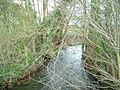
River Riccal near Harome
-
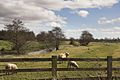
River Riccal near West Ness
-
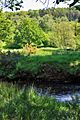
Woodland above the river Riccal


