River Thaw facts for kids
Quick facts for kids River Thaw |
|
|---|---|

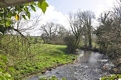
The River Thaw south of Cowbridge
|
|
| Native name | Afon Ddawan |
| Country | United Kingdom, Wales |
| Region | South Wales |
| County | Vale of Glamorgan |
| Cities | Cowbridge, Llanblethian, Aberthaw |
| Physical characteristics | |
| Main source | Southwest of Llanharry, Vale of Glamorgan, Vale of Glamorgan, Wales 51°30′30″N 3°27′03″W / 51.5082°N 3.4509°W |
| River mouth | Bristol Channel 51°22′58″N 3°23′46″W / 51.3828°N 3.3961°W |
| Length | 20.0 km (12.4 mi) |
| Discharge (location 2) |
|
| Basin features | |
| Tributaries |
|
The River Thaw (Welsh: Afon Ddawan), also known as the Ddaw, is a river located in the Vale of Glamorgan in south Wales. It stretches for about 20 kilometres (12.4 miles), making it the longest river that flows entirely within the Vale of Glamorgan.
Contents
Where Does the River Thaw Flow?
The River Thaw begins its journey in the hills just south of the M4 motorway near Llanharry. It generally flows southeast, passing through the town of Cowbridge. After Cowbridge, it turns south and eventually reaches the Bristol Channel at Breaksea Point, which is located south of Aberthaw.
Wildlife and Environment of the River Thaw
The River Thaw is home to many different types of fish. Sadly, some parts of the river no longer have European water voles, even though they used to live there in large numbers. Unlike many other rivers in south Wales, the Thaw has not had a lot of pollution. However, the area near its mouth was changed to help cool the Aberthaw Power Station.
Over the last 100 years, the variety of plants and animals in the river has slightly decreased. The Kenson River, which is a major stream flowing into the Thaw, has some pollution in its lower parts. This pollution comes from farms and from water leaking out of nearby quarries.
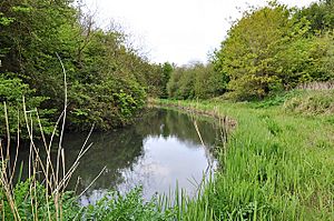
The river is also a popular spot for fun activities. Many parts of it are easy to reach, and much of the land around it is used for farming. There are also many old archaeological sites along the river's banks. Long ago, the river was wide enough for villages and towns along its banks to use boats to reach the sea. Its mouth used to be much wider, but it has become smaller over time due to mud building up and other changes.
What Are the Main Streams that Join the River Thaw?
The River Thaw has many smaller streams that flow into it along its path. This means that the area of land that drains into the Thaw is the largest in the Vale of Glamorgan.
The Kenson River: The Thaw's Biggest Helper
The Kenson River is the biggest stream that joins the Thaw. It is about 2 miles long. The Kenson forms when two other rivers, the Waycock and the Nant Llancarfan, meet. It flows southwest through the village of Penmark and close to Rhoose and Cardiff International Airport. The Kenson is also a good place for fishing and has many smaller streams flowing into it.
The River Waycock
The River Waycock is 9 kilometres long. It flows through Dyffryn and Penmark. It starts in many places between Wenvoe and St Lythans and meets the Nant Llancarfan at Penmark.
The Nant Llancarfan
The Nant Llancarfan starts at Bonvilston and flows south for 5 miles.
Other Important Streams
- The Factory Brook is about 1.5 miles long. It flows east and joins the Thaw at Cowbridge.
- The Nant y Stepsau is 2 miles long. It starts between the villages of Llanmaes and Eglwys Brewis and flows northeast.
- The Nant Tre-gof is a smaller stream. It begins near the village of Llantrithyd near the A48 road and flows southwest for almost 3 miles. It passes through a small place called Treguff, which got its name from Tre-gof. It joins the Thaw almost directly across from where the Nant y Stepsau joins.
- The Nant Aberthin is the smallest named stream. It flows through the small village of Aberthin and is less than a mile long. Its real name is Nant y Berthyn; Aberthin is a changed version of this name.
- An unnamed stream flows through St Athan. It is about 1.5 miles long and joins the Thaw near its mouth.
- The Nant Llanmihangel is over a mile long. It comes from Llanmihangel and flows into the river at Llandough, south of Llanblethian.
There are also many other small streams that flow into the Thaw but don't have names. One of these flows in the same direction as the Thaw for about a mile. It runs near an old railway line and power cables. This stream meets the Thaw near the village of Flemingston, very close to the Nant Tre-gof.
When the River Thaw Floods
On October 31, 1998, the water level in the River Thaw reached its highest point ever recorded. The river flooded, causing damage to four homes in Cowbridge, four in Aberthin, and seventeen in Llanblethian. The flooding happened because the river's banks overflowed, and water couldn't flow easily through the channels and drains.
The River Thaw's Journey to the Sea
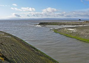
The River Thaw meets the Bristol Channel at a pebble beach called Leys Beach, located at Breaksea Point. This is one of the southernmost spots in Wales. The river flows through the village of Aberthaw.
Near its mouth is the Aberthaw Power Station, which used to have two parts, Aberthaw A and Aberthaw B, on opposite sides of the river. When Aberthaw A first opened in February 1966, it was considered the most advanced power station in the world. Aberthaw B opened in the 1970s. The power station used to burn coal to make electricity. Plans for a nuclear power station at this site were not approved because it was too close to Cardiff. Aberthaw A was taken down in 1995.
For many centuries, a small but busy port was located at the river's mouth, where ships could dock. Back then, the river was wide and deep enough for ships to travel quite a distance inland. However, the river started to fill with mud in the late 1700s. Its flow and size became so small that only a few tiny boats could use it. By 1850, it was no longer useful for shipping at all, as it had become just a large stream. The port was completely abandoned by 1900.
The Thaw's water was used to cool the power station. This caused a small amount of heat pollution at the river's mouth. The river's mouth area is not natural anymore because the river was moved into a channel to make space for the power station. This is similar to the Cadoxton River a few miles to the east. The river's original mouth was actually a little further east. Many small ponds and salt marshes are left over from what was once a much larger river mouth.
 | James B. Knighten |
 | Azellia White |
 | Willa Brown |


