
River Thurne facts for kids
Quick facts for kids Thurne |
|
|---|---|

The River Thurne at Potter Heigham
|
|

Location of the river mouth within Norfolk
|
|
| Country | England |
| Region | Norfolk |
| Physical characteristics | |
| Main source | near Martham Broad, West Somerton 1 m (3 ft 3 in) 52°43′19″N 1°39′14″E / 52.7219°N 1.6539°E |
| River mouth | River Bure Thurne 0 m (0 ft) 52°40′54″N 1°32′57″E / 52.6816°N 1.5492°E |
| Length | 10.6 km (6.6 mi) |
| Basin features | |
| River system | River Bure |
The River Thurne is a small river in Norfolk, England. It is part of a special area called The Broads. This river is only about 7 miles (11 km) long. It starts near Martham Broad and you can sail on it from West Somerton.
The River Thurne flows towards the southwest. It connects to other waterways like Candle Dyke and Heigham Sound. These links lead to Horsey Mere and Hickling Broad. The river then passes through Potter Heigham and under its old bridge. Finally, it joins the River Bure near Thurne village.
Contents
Exploring the River Thurne
Most of the River Thurne and its connected waterways are open for boats. However, some parts have rules about how big your boat can be.
Potter Heigham Bridge
One famous spot is the old bridge at Potter Heigham. It's a medieval bridge, meaning it's very old! Most cars now use a newer road bridge nearby. The old bridge has a narrow middle arch. This arch is the lowest bridge on The Broads. Boats need to be shorter than 6.6 feet (2.0 m) to pass under it.
The river here still has tides, but they are small, only about 6 inches (15 cm) up and down. Even so, the water can flow quite fast through the bridge. Because of this, boats you rent must have a special pilot to guide them under the bridge.
Beyond Potter Heigham
Above Potter Heigham, the river connects to Candle Dyke. This leads to Heigham Sound. From there, you can go to Hickling Broad, which has places to moor your boat. Both Heigham Sound and Hickling Broad are not very deep. The paths for boats are clearly marked. Hickling Broad is also a special nature reserve.
From Heigham Sound, Meadow Dyke goes north to Horsey Mere. Most of Horsey Mere is also a nature reserve, owned by the National Trust. The National Trust also owns Horsey Drainage Mill. Beyond Horsey Mere, there's Waxham New Cut. Boats up to 30 feet (9.1 m) long can travel about 1.5 miles (2.4 km) along this cut to Lound Bridge. The sea is very close here, less than 1 mile (1.6 km) away. But by boat, it's a much longer trip, about 26 miles (42 km)!
Near the River's Start
The main part of the river can be sailed almost all the way to where it begins. The channel goes through parts of Martham Broad. This area is a nature reserve looked after by the Norfolk Wildlife Trust. The channel leads to West Somerton staithes. Staithes are like small docks or landing places.
Lower River Sections
Below Potter Heigham, you can sail on Womack Water to Ludham. This path is about 1 mile (1.6 km) from the main river. However, it's only 4 feet (1.2 m) deep. Boats must be shorter than 46 feet (14 m) to use this route. A bit further downstream is Thurne Dyke. This dyke is only 3 feet (0.91 m) deep. You can sail about 170 yards (160 m) along it to reach the village of Thurne.
Structures Along the River
The River Thurne has some interesting structures, including old bridges and special windmills called drainage mills.
Potter Heigham Bridge
The Potter Heigham bridge is one of the most famous structures in The Broads. It has three arches. Two of them are triangular and were built in the 1300s. The middle arch is round and was added in the 1400s. The brick walls on the sides were built in the late 1700s. This bridge is a very important historical building.
A newer bridge, the A149 Potter Heigham Bypass bridge, is just north of the old one. It now carries most of the road traffic. This new bridge is higher, giving boats 7 feet 7 inches (2.31 m) of space to pass underneath.
Martham Ferry Bridge
Another place where vehicles cross the river is at Martham Ferry. In the 1920s, an old bridge was replaced with a special floating swing bridge. This bridge can swing open to let boats pass. The bridge deck floats on two large steel tanks. It pivots, or swings, from a post on the south side of the river. A chain connects it to a winch on the north bank.
This bridge helps farm vehicles get from Ferrygate Lane to Heigham Holmes. Heigham Holmes is a national nature reserve managed by the National Trust. It's surrounded by water and usually only open to visitors one day a year. To close the bridge for vehicles, water is pumped into the floating tanks, making the deck lower onto concrete supports. To open it for boats, the water is pumped out.
Drainage Mills
There are nine old drainage mills along the river banks. These mills were used to pump water from the land into the river, keeping the fields from flooding.
- Brograve Mill on Waxham New Cut was built in the early 1800s. It's now a ruin, but in 2003, it still had parts of its sails and most of its inside machinery.
- West Somerton Mill was built in 1900. It's in better shape, even though it doesn't have sails. Its inside pump and other parts are still there.
- Horsey Mill is a four-story mill owned by the National Trust. It was built in the mid-1800s to pump water into Horsey Mere. It stopped working in 1943 after being hit by lightning. It was restored in 1961 and again in 2004.
- Heigham Holmes Mill is another four-story brick tower mill from the mid-1800s. It still has most of its machinery inside.
- Martham Mill was built in 1908. It used a pump to move water. It has now been turned into a house.
- High's Mill is another four-story brick tower mill from the mid-1800s that is now a home.
- Repp's Drainage Mill below Potter Heigham is also a ruin.
Thurne Dyke Windpump
The Thurne Dyke windpump was built in 1820. Its top was blown off in a storm in 1919. It stopped working in 1936 and became a ruin. In 1949, a man named Bob Morse bought it and started to restore it. More work was done in 1962. From 1975, the Norfolk Mills Trust helped. In 2002, some parts were added to its sails, allowing the mill to turn in the wind again. It still has its original machinery inside. Bob Morse later created a museum of wind pumps from all over the world.
The last mill on the river is at St Benet's Level. It's a four-story mill built in the late 1700s. It was restored in 1976, and most of its machinery is still working.
Images for kids
-
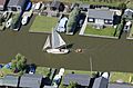
Sailing on the Thurne through Potter Heigham
-
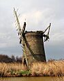
The old Brograve drainage mill. An electric pump now does its job.
.jpg)

