
Rivière-Rouge facts for kids
Quick facts for kids
Rivière-Rouge
|
|
|---|---|
|
City
|
|
 |
|

Location within Antoine-Labelle RCM
|
|

Rivière-Rouge
Location in Central Quebec
|
|
| Country | Canada |
| Province | Quebec |
| Region | Laurentides |
| RCM | Antoine-Labelle |
| Constituted | December 18, 2002 |
| Area | |
| • Total | 499.64 km2 (192.91 sq mi) |
| • Land | 451.43 km2 (174.30 sq mi) |
| Population
(2021)
|
|
| • Total | 4,631 |
| • Density | 10.3/km2 (27/sq mi) |
| • Pop. 2016-2021 | |
| • Dwellings | 3,082 |
| Time zone | UTC−5 (EST) |
| • Summer (DST) | UTC−4 (EDT) |
| Postal code(s) |
J0T 1T0 & J0T 2X0
|
| Area code(s) | 819 |
| Highways | |
Rivière-Rouge is a city in Quebec, Canada. It is located in the Antoine-Labelle Regional County Municipality. The city's name means "Red River" in French. In 2021, about 4,631 people lived there.
Contents
History of Rivière-Rouge
The city of Rivière-Rouge was formed on December 18, 2002. It was created by joining four smaller places: L'Annonciation, La Macaza, Sainte-Véronique, and Canton Marchand. This was part of a plan to reorganize towns in Quebec.
After a vote in 2004, La Macaza decided to become a separate town again. This happened on January 1, 2006. Even though La Macaza is separate, it still works with Rivière-Rouge on some services. These shared services include 911 calls, public safety, and recycling.
The original villages are now called sectors within Rivière-Rouge. These are L'Annonciation, Marchand, and Sainte-Véronique. Many people still use the old names for these areas.
How Rivière-Rouge Got Its Name
The city is named after the Rouge River. This river flows through the area. The Rouge River is a branch of the Ottawa River. The region has always been known as La Vallée de la Rouge, which means "The Valley of the Red". This is likely why the city was given its name.
Before the city was formed, the villages of L'Annonciation and Canton Marchand often worked together. L'Annonciation was created in 1908 from the "Downtown" part of Marchand. So, in a way, it has now rejoined its original area.
Population and Languages
In 2021, Rivière-Rouge had a population of 4,631 people. This was a small increase from its population in 2016. The city covers a land area of about 451.43 square kilometers. This means there are about 10.3 people living in each square kilometer.
Languages Spoken in Rivière-Rouge
Most people in Rivière-Rouge speak French as their first language.
- French is the first language for 96.2% of people.
- English is the first language for 2% of people.
- A small number of people (0.6%) speak both English and French as their first language.
- Other languages are spoken by 0.9% of the population.
City Services and Buildings
Getting Around: Transportation
The government has been planning a new road for Route 117. This highway goes through the L'Annonciation area. The new road would help reduce traffic jams. It would go around the village to the west. This new route is expected to cut traffic in downtown L'Annonciation by about 75%.
Local Hospital Services

Rivière-Rouge has a regional hospital called Le Centre Hospitalier Des Laurentides (CHDL). It is located in the L'Annonciation sector, right by the main highway. This hospital offers many health services for the community.
Police and Fire Services
The city does not have its own police force. Instead, the Sûreté du Québec (Quebec's provincial police) provides police services. Their office is in nearby Mont-Laurier.
Rivière-Rouge has a volunteer fire department. It has two fire stations. One station serves the Ste-Véronique area. The other station serves both the L'Annonciation and Marchand areas. Before the city was formed, L'Annonciation and Canton Marchand shared a fire department. The city still uses the same buildings and equipment.
Education for Kids

The Commission scolaire Pierre-Neveu (CSPN) runs French-language schools in Rivière-Rouge. There are two public schools in the city.
- École du Méandre is in the L'Annonciation sector. This school teaches students from kindergarten up to grade 9 (Secondary 3). It is the elementary school for L'Annonciation and Marchand. It also serves as the junior high school (grades 7-9) for several nearby towns. These towns include La Macaza, L’Ascension, Nominingue, Ste-Véronique, and Lac Saguay.
- École du Christ-Roi is part of École des Trois Sentiers. It is an elementary school for grades kindergarten to 6. It is located in the Ste-Véronique sector.
After grade 9, students go to École Polyvalente St-Joseph in Mont-Laurier to finish high school.
For English-speaking students, Saint Agathe Academy provides education. This school is part of the Sir Wilfrid Laurier School Board. It is located in Sainte-Agathe-des-Monts.
Images for kids
-
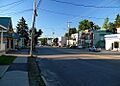
A view of Rivière-Rouge
-
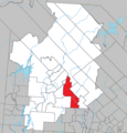
Map showing Rivière-Rouge in Quebec
See also
 In Spanish: Rivière-Rouge para niños
