Rouge River (Laurentides) facts for kids
Quick facts for kids Rouge River |
|
|---|---|

|
|
| Country | Canada |
| Province | Quebec |
| Region | Laurentides |
| MRC | Argenteuil Regional County Municipality |
| Municipality | Rivière-Rouge, Brébeuf |
| Physical characteristics | |
| Main source | Lac de la Fougère Lac-Matawin 549 m (1,801 ft) 47°04′41″N 74°25′41″W / 47.07806°N 74.42806°W |
| River mouth | Ottawa River Grenville-sur-la-Rouge 41 m (135 ft) 45°38′34″N 74°41′30″W / 45.64278°N 74.69167°W |
| Length | 161 km (100 mi) |
| Basin features | |
| Progression | Ottawa River→ Saint Lawrence River→ Gulf of Saint Lawrence |
| River system | Ottawa River drainage basin |
| Tributaries |
|
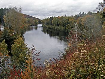
The Rouge River (which means "Red River" in English) is a beautiful river in Quebec, Canada. It flows through the Laurentides region, which is in western Quebec. This river is about halfway between the cities of Ottawa and Montreal.
The Rouge River is 161 kilometres (100 mi) long. It starts at a lake called Lac de la Fougère. From there, it flows south until it joins the Ottawa River near Pointe-au-Chêne. The river gets its name from the reddish color of its sandy banks.
This river is super popular for whitewater rafting! The last 10 kilometres (6.2 mi) of the river are especially famous for this exciting sport. The Rouge River is the main waterway in an area full of hills, valleys, lakes, and amazing waterfalls.
Contents
River Features and Landmarks
The Rouge River has some cool spots along its path. These include:
- The mouth of the river, where it meets the Ottawa River: 45°38′34″N 74°41′27″W / 45.64278°N 74.69083°W
- Rapides Maskinongé: 45°49′56″N 74°39′55″W / 45.83222°N 74.66528°W
- Exciting sections for rafters like The Canyons, The Turbo, Surprise, and Devil's Door.
Where the Water Comes From
The Rouge River gets its water from many smaller rivers and streams. These are called its "watersheds." Here are some of the main ones:
- From the north: Maskinongé River.
- From the west: Petite rivière Saumon, Petite-Nation River, and Nominingue River.
- From the east: Kingham River, Calumet River, Beaven River, Diable River, Macaza River, and Lenoir River.
- From the south: The Ottawa River (which the Rouge River flows into).
The Rouge River starts at Lac de la Fougère, which is about 550 metres (1,800 ft) high. As it flows south, it goes through Red Lake. The river also forms the western edge of the Rouge-Matawin Wildlife Reserve. By the time it leaves this reserve, it has already dropped more than 275 metres (902 ft) in height!
The river's path changes from a rocky area to a sandy plain. It passes through towns like L'Ascension, Labelle, and La Conception. Further downstream, it meets the Nominingue River and then turns southeast. Finally, after its 161 kilometres (100 mi) journey, the Rouge River flows into the Ottawa River.
The last 10 kilometres (6.2 mi) of the river are especially exciting with many falls and rapids. Some of its main smaller rivers joining it are the Lenoir River, Macaza River, and rivière du Diable from the east. From the west, it gets water from the Maskinongé River and the Nominingue River.
The entire area that drains water into the Rouge River is about 5,543 kilometres (3,444.26 mi). Most of the river is calm, with many bends and curves, except for those last 10 kilometres (6.2 mi) of rapids!
The 2019 Floods
In April 2019, the Rouge River experienced very heavy flooding. The amount of water flowing was 10 times more than usual! Because of this, people worried that the Bells Fall dam might break. Authorities had to move people living downstream of the dam to safety.
A Mythic Creature: Bisso
Have you heard of "Bisso"? This creature is part of Canadian folklore and is said to live in the Rouge River! The story goes that a long time ago, a man riding in a horse-drawn carriage fell into the river and was thought to have died. Years later, he supposedly turned into a big, watery creature that lived in the river.
Bisso is said to be very hungry and would hunt any animals that came near the river bank. It's believed to swim with only its eyes above the water, using floating plants to hide itself while it waits for prey. Some people claim to have seen Bisso's eyes in the Rouge River, and even trails of bubbles from its "snaps" (which are described as gaseous bowel movements).
History of the Rouge River Area
The area around the Rouge River was once home to the Iroquois people until the late 1800s. A priest named François-Xavier-Antoine Labelle helped lead people to settle along the river. This led to the creation of many communities along the Rouge River and its smaller streams. The Chute Bell Powerhouse, which generates electricity, was built about 15 kilometres (9.3 mi) from the river's mouth in 1915.
The Rouge River valley was an important path for pioneers who wanted to settle in the north of Montreal. In French Canada, Catholic churches helped plan and organize new communities in these areas.
A map from 1699 by Franquelin showed the "Red River" as an extension of the "North River." Historians think the river's name comes from the slightly reddish color of its water. This color is likely from certain types of rocks in the Canadian Shield that the river flows through. However, some say its water is actually clearer than other nearby rivers. Another idea is that the name comes from a red chalk deposit near Grand lac Nominingue. The Algonquins and Iroquois used this chalk for painting themselves.
The name "Rouge" (Red) from the river was also given to the Rouge-Matawin Wildlife Reserve, which is located along the river's western edge.
The name "Rivière Rouge" was officially recognized on December 5, 1968, by the Commission de toponymie du Québec. The river has also given its name to other places, like the Rivière-Rouge Ecological Reserve and the communities of Rivière-Rouge and Grenville-sur-la-Rouge.
See also
- Ottawa River, a major river
- Petite rivière Saumon, a smaller stream
- Macaza River, another stream
- Maskinongé River, a watercourse
- Grenville-sur-Rouge, a municipality
- Argenteuil Regional County Municipality (MRC)
- List of rivers of Quebec
 | John T. Biggers |
 | Thomas Blackshear |
 | Mark Bradford |
 | Beverly Buchanan |


