Rivière à l'Orme facts for kids
Quick facts for kids Rivière à l’Orme |
|
|---|---|

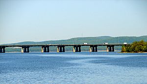
Île aux Tourtes Bridge across Lake of Two Mountains, with Mont Oka in the background
|
|
| Other name(s) | English: Elm River |
| Country | Canada |
| Province | Quebec |
| Region | Montreal |
| Physical characteristics | |
| Main source | Urban creek Pierrefonds, Quebec, Montreal, Quebec 31 m (102 ft) 45°26′35″N 73°53′07″W / 45.44306°N 73.88528°W |
| River mouth | Lac des Deux Montagnes (anse à l’Orme) Senneville, Quebec, Montreal, Quebec 23 m (75 ft) 45°27′01″N 73°56′17″W / 45.45028°N 73.93806°W |
| Length | 5.1 km (3.2 mi) |
The Rivière à l'Orme (which means Elm River in English) is a small river in Quebec, Canada. It flows into the Lac des Deux Montagnes. This river runs through parts of Pierrefonds, Quebec and Senneville, Quebec, both areas within the big city of Montreal.
Most of the river's path goes through city areas and urban parks. If you visit in winter, you'll find the river's surface usually frozen from mid-December to late March. It's safest to walk on the ice from late December to mid-March.
Contents
Where is the Rivière à l'Orme Located?
The Rivière à l'Orme is surrounded by other important bodies of water. Think of it like a neighborhood of rivers and lakes!
- To the north, you'll find the Lac des Deux Montagnes and the Ottawa River.
- To the east, there's the Rivière des Prairies and Lake St. Louis.
- To the south, it's bordered by Lake St. Louis and the mighty St. Lawrence River.
- And to the west, it's again near the Lac des Deux Montagnes.
The River's Journey
The Rivière à l'Orme starts in the southwestern part of the Pierrefonds area of Montreal. It begins near the Cineplex Kirkland Theater.
From its start, the river flows for about 5.1 kilometers (about 3.2 miles). Here's how it travels:
- First, it goes southwest for about 1.5 kilometers (0.9 miles). It runs alongside the Autoroute 40 and crosses the Timberlea Trail.
- Then, it turns northwest for about 3.6 kilometers (2.2 miles) until it reaches its mouth. A road called "Anse à l'Orme road" follows this part of the river.
The Rivière à l'Orme finally empties into the eastern shore of "Anse à l'Orme," which is a natural part of the Lac des Deux Montagnes. Near its end, the river flows through the L'Anse-à-l'Orme Nature Park.
Key Locations Near the River's Mouth
The mouth of the river is located:
- About 2.6 kilometers (1.6 miles) south of where the Lac des Deux Montagnes itself flows out.
- About 5.5 kilometers (3.4 miles) north of the Galipeault Bridge, which connects Sainte-Anne-de-Bellevue, Quebec to Perrot Island.
- About 2.8 kilometers (1.7 miles) south of Île Bizard, another part of Montreal.
- About 5.4 kilometers (3.4 miles) southeast, across from Pointe-Calumet.
Why is it Called Rivière à l'Orme?
The name "Rivière à l'Orme" has been used for this river since at least 1925. This name (which means Elm River) actually honors a person named Julien Hubert dit de Lorme. He was given a piece of land in 1668 right next to a cove called "Orme cove." This cove is at the western end of the island of Montreal.
For a long time, many historians mistakenly thought the river was named after elm trees growing in the area. But it's really connected to Julien Hubert dit de Lorme and the nearby places named "Cap à l'Orme" and "Anse à l'Orme."
The official name "Rivière à l'Orme" was made formal on December 5, 1968, by the Commission de toponymie du Québec, which is the official body for naming places in Quebec.
 | Percy Lavon Julian |
 | Katherine Johnson |
 | George Washington Carver |
 | Annie Easley |

