Rivière aux Ormes (Petite rivière du Chêne) facts for kids
Quick facts for kids Rivière aux Ormes |
|
|---|---|

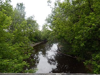
Rivière aux Ormes at Fortierville seen from the bridge of the “Le Petit-Deschaillons” cycle path.
|
|
| Country | Canada |
| Province | Quebec |
| Region | Centre-du-Québec |
| MRC | L'Érable Regional County Municipality, Bécancour Regional County Municipality |
| Physical characteristics | |
| Main source | Agricultural and forest streams Villeroy 122 metres (400 ft) 46°24′07″N 71°50′06″W / 46.401926°N 71.834963°W |
| River mouth | Petite rivière du Chêne Parisville et Fortierville 32 metres (105 ft) 46°29′22″N 72°04′47″W / 46.48944°N 72.07972°W |
| Length | 20.6 kilometres (12.8 mi) |
| Basin features | |
| River system | St. Lawrence River |
| Tributaries |
|
The Rivière aux Ormes (which means Elm River in English) is a river in Quebec, Canada. It flows into the Petite rivière du Chêne, which then joins the mighty St. Lawrence River. This river runs through several towns, including Villeroy, Sainte-Françoise, and Fortierville. It's located in the Centre-du-Québec region.
Where the River Flows
The Rivière aux Ormes starts north of Highway 20. This starting point is near the town of Villeroy. It begins from small streams in farm and forest areas.
From its source, the river flows for about 29.6 kilometres (18.4 mi) (about 18.4 miles). It drops about 90 metres (300 ft) (295 feet) in elevation along its path. The river generally flows northwest.
It passes through different areas:
- It starts in Villeroy.
- Then it crosses into Sainte-Françoise.
- Finally, it reaches Fortierville.
The Rivière aux Ormes eventually meets the Petite rivière du Chêne. This meeting point is between the towns of Fortierville and Parisville.
What's in a Name?
The name “Rivière aux Ormes” means "Elm River." It was officially named on December 5, 1968. This name was given by the Commission de toponymie du Québec, which is the group in charge of naming places in Quebec.
 | Aurelia Browder |
 | Nannie Helen Burroughs |
 | Michelle Alexander |


