Rivière de la Grande Coudée facts for kids
Quick facts for kids Rivière de la Grande Coudée |
|
|---|---|

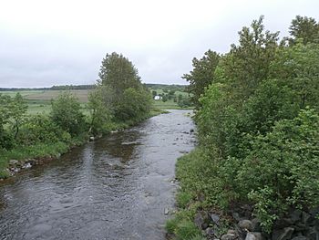
Rivière de la Grande Coudée towards its confluence with the Chaudière river.
|
|
| Country | Canada |
| Province | Quebec |
| Region | Chaudière-Appalaches |
| MRC | Beauce-Sartigan Regional County Municipality |
| Physical characteristics | |
| Main source | Forest streams Saint-Hilaire-de-Dorset 428 metres (1,404 ft) 45°47′00″N 70°46′21″W / 45.783254°N 70.772419°W |
| River mouth | Chaudière River Saint-Martin 230 metres (750 ft) 45°55′49″N 70°39′16″W / 45.93028°N 70.65444°W |
| Length | 32.4 kilometres (20.1 mi) |
| Basin features | |
| Progression | Chaudière River, St. Lawrence River |
| River system | St. Lawrence River |
| Tributaries |
|
The Rivière de la Grande Coudée (which means "river of the great cubit" in English) is a river in Quebec, Canada. It flows into the Chaudière River, which then empties into the St. Lawrence River. This river runs through the towns of Saint-Hilaire-de-Dorset, Saint-Gédéon-de-Beauce, and Saint-Martin. These towns are part of the Beauce-Sartigan Regional County Municipality in the Chaudière-Appalaches region.
Contents
Exploring the Grande Coudée River
The Grande Coudée River is an important part of the local water system. It collects water from a large area, which is called a watershed. Understanding its path helps us see how water flows through the region.
Where the River Starts
The Grande Coudée River begins in a swampy area. This swamp is located where the Dorset and Gayhurst townships meet. It's also very close to the border between two regional county municipalities: Beauce-Sartigan Regional County Municipality and Le Granit Regional County Municipality.
The source of the river is about 7.3 kilometres (4.5 mi) northwest of the village of Saint-Ludger. It's also about 7.8 kilometres (4.8 mi) northeast of Drolet Lake, which is in the town of Lac-Drolet.
How the River Flows
The Grande Coudée River travels a total of 32.4 kilometres (20.1 mi). Its journey can be broken down into several parts:
- It flows about 2.3 kilometres (1.4 mi) northwest, reaching the outlet of Oliveira Lake.
- Then, it continues 3.8 kilometres (2.4 mi) northwest, picking up water from a stream in an area called "Les Fourches," until it reaches the outlet of Lac Rond.
- Next, it goes 6.7 kilometres (4.2 mi) northeast, until it meets the water flowing out of Lac des Îles.
- For 9.0 kilometres (5.6 mi), it winds its way northeast. This part of the river forms the border between Saint-Hilaire-de-Dorset and Saint-Gédéon-de-Beauce.
- It then flows 1.5 kilometres (0.93 mi) northeast, winding again, until it reaches the border between Saint-Gédéon-de-Beauce and Saint-Martin.
- It continues for 5.6 kilometres (3.5 mi) northeast, winding until it meets a stream coming from the northwest.
- Finally, it travels 3.5 kilometres (2.2 mi) eastward to its end point.
Where the River Ends
The Grande Coudée River finishes its journey by flowing into the Chaudière River in Saint-Martin. This meeting point is about 1.4 kilometres (0.87 mi) upstream from the bridge in the village of Saint-Martin. It is also downstream from the village of Saint-Gédéon-de-Beauce.
The Name of the River
The name of the river, Rivière de la Grande Coudée, has an interesting history.
Understanding "Coudée"
For a long time, people often called this river "Grande Coulée," especially after 1937. The word "coulée" often means a ravine or a small valley with a stream that might not always flow.
However, the name "Grande Coudée" was used even earlier. It was recorded by explorers like Vondenvelden and Charland in 1803, and Bouchette in 1832. The word "coudée" (cubit) describes how the river bends and turns, like an elbow. This shows the unique shape of the river's path.
Early Settlements
As early as 1860, pioneers began to settle near the mouth of this river. This area became known as the Grande Coudée. A Catholic mission was even established there, also called Grandes-Coudées.
The official name, Rivière de la Grande Coudée, was confirmed on October 19, 1990. This was done by the Commission de toponymie du Québec, which is the official body for naming places in Quebec.
 | James Van Der Zee |
 | Alma Thomas |
 | Ellis Wilson |
 | Margaret Taylor-Burroughs |


