Robles, San Sebastián, Puerto Rico facts for kids
Quick facts for kids
Robles
|
|
|---|---|
|
Barrio
|
|

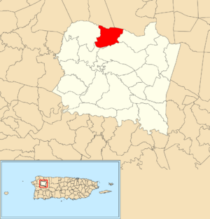
Location of Robles within the municipality of San Sebastián shown in red
|
|
| Commonwealth | |
| Municipality | |
| Area | |
| • Total | 2.74 sq mi (7.1 km2) |
| • Land | 2.74 sq mi (7.1 km2) |
| • Water | 0 sq mi (0 km2) |
| Elevation | 571 ft (174 m) |
| Population
(2010)
|
|
| • Total | 1,697 |
| • Density | 619.3/sq mi (239.1/km2) |
| Source: 2010 Census | |
| Time zone | UTC−4 (AST) |
Robles is a special kind of neighborhood, called a barrio, located in the town of San Sebastián, Puerto Rico in Puerto Rico. In 2010, about 1,697 people lived there.
A Look at Robles' Past
After the Spanish–American War ended in 1898, Spain gave Puerto Rico to the United States. This made Puerto Rico a U.S. territory. In 1899, the U.S. government took a count of all the people in Puerto Rico. They found that Robles and a nearby barrio called Salto had a combined population of 1,646 people.
Understanding Robles' Sections
Barrios like Robles are often divided into smaller local areas. These smaller areas are called sectores (which means sectors in English). The names for these sectors can be different. Some are just called "sector," while others might be called "urbanización" or "reparto."
Here are some of the sectors you can find in Robles barrio:
- Carretera 446
- Carretera 447
- Carretera 4446
- Sector Cuatro Calles
- Sector El Paraíso
- Sector Farel Velázquez
- Sector Genove González
- Sector La Conquista
- Sector Las Piedras
- Sector Lito Ramos
- Sector Pedro Lisojo
- Sector Peña
- Sector Pochín Serrano
- Sector Ricardo Morales
- Urbanización Antonio Muñiz
See also
 In Spanish: Robles (San Sebastián) para niños
- List of communities in Puerto Rico
- List of barrios and sectors of San Sebastián, Puerto Rico
 | John T. Biggers |
 | Thomas Blackshear |
 | Mark Bradford |
 | Beverly Buchanan |


