
Roi-Namur facts for kids
|
Roi–Namur Battlefield
|
|

Location in Marshall Islands
|
|
| Location | Kwajalein Missile Range, Kwajalein Atoll |
|---|---|
| Built | 1944 |
| NRHP reference No. | 85001758 |
Quick facts for kids Significant dates |
|
| Added to NRHP | February 4, 1985 |
| Designated NHLD | February 4, 1985 |
Roi-Namur is a special island in the northern part of the Kwajalein Atoll. This atoll is located in the Marshall Islands. Today, Roi-Namur is a very important part of the Ronald Reagan Ballistic Missile Defense Test Site. It has several large radar systems. These radars are used to track and study missile parts as they return to Earth.
Contents
What's in a Name?
The island we call Roi-Namur today used to be two separate islands. Their names were Roi and Namur. They were joined together by adding a lot of land. The name Roi comes from the Marshallese word Ruot. Namur comes from the Marshallese word Nim̧ur.
A Look Back in Time
Early Days and World War II
In 1885, Germany took control of the Marshall Islands. They let German trading companies manage things until 1906. After World War I, Japan took over the islands. They built many strong bases on different islands, including Roi and Namur.
During World War II, in February 1944, American forces fought a big battle here. It was called the Battle of Kwajalein. The U.S. 4th Marine Division targeted Roi-Namur. At that time, Roi (to the west) and Namur (to the east) were connected by a narrow strip of land. After the American forces took control, they filled in the area between the islands. By December 1944, the two islands became one. This new, larger island is now called Roi-Namur. It is about one square mile in size.
Radar Experiments and Research
Later, Roi-Namur was chosen for important radar experiments. These experiments were part of a project called Project PRESS. Scientists wanted to use radar to tell the difference between a missile's main part and other objects that might be traveling with it. They studied the size, shape, and speed of these objects. They also looked at the trails they left in the upper atmosphere. By building on Roi-Namur, they could use test shots from other nearby islands.
In March 2014, a very large wave flooded the island. It covered the roads along the coast.
Roi-Namur Today
Today, about 120 American and Marshallese people live and work on Roi-Namur. They are employees of the Reagan Test Site.
The Roi side of the island is where most people live. It has shops and places for fun activities. People on Roi-Namur can enjoy a nine-hole golf course and a saltwater swimming pool. There is also a scuba diving club, a movie theater, and courts for volleyball and basketball. Roi also has a runway for small planes. These planes bring more workers from Kwajalein Island. Other Marshallese workers come by ferry from the island of Enniburr each day.
The Namur side of the island is home to important radar tracking stations. These include the ALCOR, ALTAIR, MMW, and TRADEX radars.
There is also a small launch facility on Roi-Namur. Rockets launched here are usually "sounding rockets." These rockets go high into the atmosphere but travel short distances. You can still see crumbling remains of Japanese blockhouses and pillboxes around Roi-Namur. These were built during World War II.
Images for kids
-
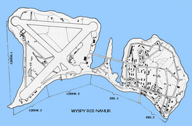
Map of Roi-Namur during World War II. The causeway is roughly centered.
-
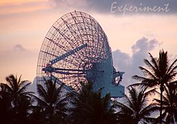
ALTAIR radar


