
Roscoe, Pennsylvania facts for kids
Quick facts for kids
Roscoe
|
|
|---|---|
|
Borough
|
|
 |
|

Location of Roscoe in Washington County, Pennsylvania.
|
|

Roscoe
Location in Pennsylvania
|
|
| Country | United States |
| State | Pennsylvania |
| County | Washington |
| Established | 1894 |
| Area | |
| • Total | 0.25 sq mi (0.64 km2) |
| • Land | 0.18 sq mi (0.47 km2) |
| • Water | 0.06 sq mi (0.17 km2) |
| Population
(2020)
|
|
| • Total | 720 |
| • Density | 3,956.04/sq mi (1,528.02/km2) |
| Time zone | UTC-4 (EST) |
| • Summer (DST) | UTC-5 (EDT) |
| Zip Code |
15477
|
| Area code(s) | 724 |
Roscoe is a small town, called a borough, in Washington County, Pennsylvania, United States. In 2020, about 716 people lived there.
Contents
History of Roscoe
Roscoe became home to many families from Eastern Europe. They moved to the area to work in the nearby coal mines. People from Slovakia, Poland, Serbia, Croatia, Italy, and Hungary came here. These groups are listed in records from the 1880s and later.
A train line called the Allenport & Roscoe Street Railway started in 1903. It later became part of a bigger train system that connected to Pittsburgh. The train line reached Roscoe in 1910. However, it closed down in 1953.
The town was first called Lucyville around 1860. Later, its name changed to Roscoe. This new name honored Mrs. Joseph Underwood, a local resident. Roscoe was officially established as a borough in 1894.
Coal Mining in Roscoe
Roscoe was an important place for coal mining. Many coal mines were located in and around the town. These mines provided jobs for many people.
Geography of Roscoe
Roscoe is located in Pennsylvania. Its exact location is 40 degrees North and 79 degrees West.
The United States Census Bureau says the borough covers about 0.2 square miles (0.5 square kilometers). Most of this area is land. About 0.04 square miles (0.1 square kilometers) is water. This means about 16.67% of Roscoe is water.
Neighboring Areas
Roscoe shares land borders with two other places. To the north and east is Allenport. To the west is Elco.
Across the Monongahela River to the south, Roscoe is next to Jefferson Township. This township is in Fayette County.
Population and People

In 2000, there were 848 people living in Roscoe. These people made up 398 households. About 243 of these households were families.
The population density was about 4,256 people per square mile. There were 426 housing units in the borough.
Most people in Roscoe were White (98.35%). A small number were Black (0.94%) or from other backgrounds. About 0.35% of the population was Hispanic or Latino.
Households and Families
About 20.6% of households had children under 18 living with them. Nearly half (47.0%) were married couples living together. About 11.3% had a female head of household with no husband present.
Many households (38.9%) were not families. About 36.7% of all households were made up of single individuals. About 19.6% of households had someone aged 65 or older living alone.
The average household had 2.13 people. The average family had 2.77 people.
Age and Income
The population of Roscoe was spread out by age. About 17.8% were under 18 years old. About 25.2% were 65 years or older. The average age in Roscoe was 46 years.
The median income for a household in Roscoe was $31,094. For a family, the median income was $41,250. The average income per person in the borough was $17,508.
About 6.1% of all people in Roscoe lived below the poverty line. This included 8.4% of those under 18. It also included 5.3% of those aged 65 or older.
Images for kids
-
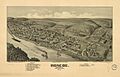
A 1902 map of Roscoe by Thaddeus Mortimer Fowler.
See also
 In Spanish: Roscoe (Pensilvania) para niños
