Rowley Island facts for kids

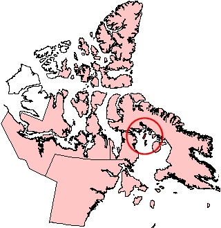
Rowley Island, Nunavut.
|
|
| Geography | |
|---|---|
| Location | Foxe Basin |
| Coordinates | 69°06′N 78°52′W / 69.100°N 78.867°W |
| Archipelago | Canadian Arctic Archipelago |
| Area | 1,090 km2 (420 sq mi) |
| Administration | |
| Nunavut | Nunavut |
| Region | Qikiqtaaluk |
| Demographics | |
| Population | 62 (2016) |
Rowley Island is a fascinating island located in the Canadian Arctic Archipelago. It is part of the Qikiqtaaluk Region in Nunavut, Canada. This island sits in the Foxe Basin and covers an area of about 1,090 square kilometers (420 square miles). That's a pretty big piece of land!
Contents
Exploring Rowley Island's Features
Rowley Island is unique because it is currently uninhabited. This means no people live there permanently. However, it still plays an important role.
Unmanned Stations on the Island
Even though no one lives on Rowley Island, it has some important equipment.
- Distant Early Warning Line Base: There is an unmanned base called FOX-1. This base was once part of the Distant Early Warning Line, or DEW Line. The DEW Line was a chain of radar stations built during the Cold War. Their job was to detect if any aircraft were coming over the North Pole. This helped protect North America.
- Automated Weather Station: The island also has an Automated Surface Observing System (ASOS). This is like a robot weather reporter! It automatically collects weather information, such as temperature, wind speed, and air pressure. This data is very helpful for weather forecasts and understanding the Arctic climate.
How Rowley Island Got Its Name
Rowley Island is named after a brave Arctic explorer. His name was Graham Westbrook Rowley. Explorers like him helped map out and understand the vast and icy lands of the Arctic.
See also
 In Spanish: Isla Rowley para niños

All content from Kiddle encyclopedia articles (including the article images and facts) can be freely used under Attribution-ShareAlike license, unless stated otherwise. Cite this article:
Rowley Island Facts for Kids. Kiddle Encyclopedia.


