Royalton, Indiana facts for kids
Quick facts for kids
Royalton, Indiana
|
|
|---|---|

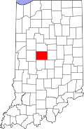
Boone County's location in Indiana
|
|
| Country | United States |
| State | Indiana |
| County | Boone |
| Township | Eagle |
| Elevation | 919 ft (280 m) |
| Time zone | UTC-5 (Eastern (EST)) |
| • Summer (DST) | UTC-4 (EDT) |
| ZIP code |
46077
|
| FIPS code | 18-66258 |
| GNIS feature ID | 442375 |
Royalton is a small place in Indiana, a state in the United States. It's known as an unincorporated community. This means it's a group of homes and businesses that don't have their own local government, like a mayor or city council. Instead, it's part of a larger area called Eagle Township in Boone County.
Contents
Royalton's Past
Royalton has a bit of history, even if it's a small place.
Early Days of Communication
A post office was opened in Royalton way back in 1832. For a short time, it was actually called "Rodmans" until 1838. This post office helped people send and receive letters and packages. It stayed open for many years, but eventually closed down in 1903.
Where is Royalton?
Royalton is located in the central part of Indiana.
Finding Royalton on a Map
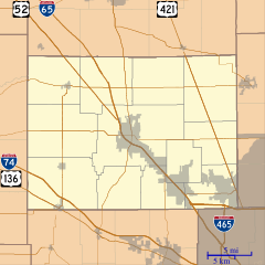
You can find Royalton at these coordinates: 39°55′37″N 86°20′18″W / 39.92694°N 86.33833°W. It's situated along a road called Indianapolis Road. It's about 0.7 miles northwest of Marion County.
Streets in Royalton
Even though it's a small community, Royalton has a few main streets. These include Royal Avenue, Circle Drive, and Harmon Avenue.


