S.N.P.J., Pennsylvania facts for kids
Quick facts for kids
S.N.P.J., Pennsylvania
Slovenska Narodna Podporna Jednota (Slovene)
|
|
|---|---|
|
Borough
|
|

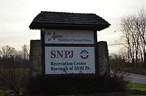
Welcome sign along Pennsylvania Route 108
|
|

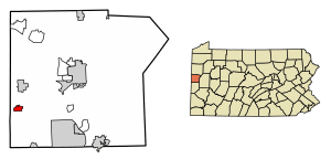
Location in Lawrence County, Pennsylvania
|
|
| Country | United States |
| State | Pennsylvania |
| County | Lawrence |
| Established | 1978 |
| Area | |
| • Total | 0.78 sq mi (2.01 km2) |
| • Land | 0.75 sq mi (1.94 km2) |
| • Water | 0.03 sq mi (0.07 km2) |
| Highest elevation
(northeast corner)
|
1,250 ft (380 m) |
| Lowest elevation
(tributary to Sugar Creek)
|
1,055 ft (322 m) |
| Population
(2020)
|
|
| • Total | 15 |
| • Density | 25.37/sq mi (9.80/km2) |
| Time zone | UTC-4 (EST) |
| • Summer (DST) | UTC-5 (EDT) |
| ZIP code |
16120
|
| Area code(s) | 724 |
| FIPS code | 42-71620 |
| GNIS feature ID | 2390560 |
S.N.P.J. is a small borough located in western Lawrence County, Pennsylvania, United States. A borough is like a small town with its own local government. In 2020, only 15 people lived here. It is part of the larger Pittsburgh area.
S.N.P.J. stands for "Slovenska Narodna Podporna Jednota." This is a Slovene phrase that means "Slovene National Benefit Society." This society is a group that helps its members, like a club that also offers financial support. It is based in North Fayette, Pennsylvania.
The society owns a large recreation center in western Pennsylvania. In 1977, they asked for this center to become its own separate town or "municipality." The S.N.P.J. borough was created so the society could make its own rules for the recreation center. This helped them manage activities at their property, especially on Sundays. Before this, the area was part of North Beaver Township, which had different rules.
For a while, S.N.P.J. was known as the borough with the fewest people in Pennsylvania. However, another borough called Centralia became unsafe to live in because of a mine fire. This changed the record for the smallest population.
Contents
Geography and Recreation
S.N.P.J. is located at 40°55′44″N 80°29′55″W / 40.92889°N 80.49861°W. The area is about 0.7 square miles, and a small part of it is covered by water.
This borough is more like a big recreation complex than a typical town. It has many things for visitors to enjoy. There are 60 cabins you can rent and 115 spots for mobile homes. There is also an artificial lake where people can have fun.
The recreation complex is open to everyone, especially during the summer. It's a popular spot for different events. People come here for bingo games, weddings, and dances. Members of the Slovene National Benefit Society get special discounts on these events.
Population Over Time
| Historical population | |||
|---|---|---|---|
| Census | Pop. | %± | |
| 1980 | 16 | — | |
| 1990 | 12 | −25.0% | |
| 2000 | 14 | 16.7% | |
| 2010 | 19 | 35.7% | |
| 2020 | 15 | −21.1% | |
| 2021 (est.) | 15 | −21.1% | |
| Sources: | |||
The number of people living in S.N.P.J. has been very small since it was created. In 1980, there were 16 residents. The population has changed a little over the years, reaching 19 people in 2010. By 2020, the population was 15.
Education for Students
Students who live in S.N.P.J. attend schools in the Mohawk Area School District. This school district serves the borough and nearby areas.
Getting Around
Main Roads
 PA 108
The main road that goes through S.N.P.J. is Pennsylvania Route 108. This road helps people travel to and from the borough.
See also
 In Spanish: S.N.P.J. para niños
 | Dorothy Vaughan |
 | Charles Henry Turner |
 | Hildrus Poindexter |
 | Henry Cecil McBay |

