Saín Alto Municipality facts for kids
Quick facts for kids
Saín Alto
|
||
|---|---|---|

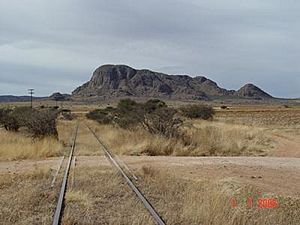
Cerro de San Nicolas, a hill in the northern part of the municipality of Saín Alto
|
||
|
||
| Country | ||
| State | ||
| Established | 17 January 1825 | |
| Seat | Saín Alto | |
| Area | ||
| • Total | 1,415.0 km2 (546.3 sq mi) | |
| Elevation
(of seat)
|
2,056 m (6,745 ft) | |
| Population
(2020 Census)
|
||
| • Total | 21,844 | |
| • Density | 15.4375/km2 (39.9828/sq mi) | |
| • Seat | 5,295 | |
| Time zone | UTC-6 (Central) | |
| • Summer (DST) | UTC-5 (Central) | |
| Postal codes |
99130–99143
|
|
| Area code | 498 | |
Saín Alto is a town and a region (called a municipality) in the state of Zacatecas, Mexico. It is about 110 kilometers (68 miles) northwest of Zacatecas City, the capital of the state.
Contents
Geography of Saín Alto
The Saín Alto municipality is located high up on the Mexican Plateau in northwestern Zacatecas. Its elevation ranges from about 1,900 to 3,000 meters (6,200 to 9,800 feet) above sea level. It shares borders with other municipalities: Río Grande to the north, Fresnillo to the south, and Sombrerete to the west. The total area of Saín Alto is 1,415 square kilometers (546 square miles). This makes up about 1.9% of the entire state of Zacatecas.
Land and Water in Saín Alto
Most of the land in Saín Alto is covered by grasslands (51%) and forests (23%). About 6% of the land has a type of dry shrubland called matorral. Farmers use another 19% of the land for growing crops. The Aguanaval River flows through the eastern part of the municipality. This river is part of an endorheic basin, which means its water does not flow into the ocean.
A part of the Sierra Madre Occidental mountain range, known as the Sierra de Chapultepec, runs through the southwestern area. This mountain range once had small amounts of mercury and tin. People mined these metals there between the 1940s and 1970s.
Climate in Saín Alto
Most of Saín Alto has a dry climate with cool, dry winters. However, the mountains in the south have a more moderate climate. The average temperature in the municipality is between 12 and 18 degrees Celsius (54 to 64 degrees Fahrenheit). The area usually gets between 400 and 700 millimeters (16 to 28 inches) of rain each year.
| Climate data for Saín Alto weather station at 23°34′48″N 103°15′50″W / 23.58000°N 103.26389°W, 2071 m above sea level (1981–2010 averages, 1951–2010 extremes) | |||||||||||||
|---|---|---|---|---|---|---|---|---|---|---|---|---|---|
| Month | Jan | Feb | Mar | Apr | May | Jun | Jul | Aug | Sep | Oct | Nov | Dec | Year |
| Record high °C (°F) | 34.0 (93.2) |
33.5 (92.3) |
36.0 (96.8) |
39.0 (102.2) |
39.0 (102.2) |
39.0 (102.2) |
38.5 (101.3) |
37.0 (98.6) |
40.0 (104.0) |
40.0 (104.0) |
36.5 (97.7) |
34.0 (93.2) |
40.0 (104.0) |
| Mean daily maximum °C (°F) | 21.6 (70.9) |
23.1 (73.6) |
25.8 (78.4) |
28.3 (82.9) |
30.3 (86.5) |
29.6 (85.3) |
27.3 (81.1) |
26.7 (80.1) |
25.5 (77.9) |
24.9 (76.8) |
23.8 (74.8) |
22.1 (71.8) |
25.8 (78.4) |
| Daily mean °C (°F) | 11.1 (52.0) |
12.6 (54.7) |
15.0 (59.0) |
17.6 (63.7) |
20.3 (68.5) |
21.1 (70.0) |
20.0 (68.0) |
19.5 (67.1) |
18.5 (65.3) |
16.3 (61.3) |
13.5 (56.3) |
11.5 (52.7) |
16.4 (61.5) |
| Mean daily minimum °C (°F) | 0.6 (33.1) |
2.0 (35.6) |
4.2 (39.6) |
6.9 (44.4) |
10.2 (50.4) |
12.7 (54.9) |
12.7 (54.9) |
12.4 (54.3) |
11.4 (52.5) |
7.7 (45.9) |
3.2 (37.8) |
0.9 (33.6) |
7.1 (44.8) |
| Record low °C (°F) | −13.0 (8.6) |
−7.5 (18.5) |
−6.0 (21.2) |
−6.5 (20.3) |
2.0 (35.6) |
2.0 (35.6) |
2.0 (35.6) |
0.0 (32.0) |
1.0 (33.8) |
−4.0 (24.8) |
−8.0 (17.6) |
−13.0 (8.6) |
−13.0 (8.6) |
| Average precipitation mm (inches) | 12.7 (0.50) |
9.7 (0.38) |
2.4 (0.09) |
5.1 (0.20) |
20.8 (0.82) |
76.2 (3.00) |
103.9 (4.09) |
110.0 (4.33) |
89.4 (3.52) |
36.1 (1.42) |
11.5 (0.45) |
9.0 (0.35) |
486.8 (19.17) |
| Average rainy days (≥ 1 mm) | 2.0 | 1.3 | 0.6 | 1.0 | 3.4 | 8.3 | 12.3 | 12.3 | 9.9 | 5.4 | 1.7 | 1.5 | 59.7 |
| Source: Servicio Meteorológico Nacional | |||||||||||||
History of Saín Alto
The name Saín Alto comes from a group of Zacateco people called Saín. These people founded the settlement of Saín Alto around 1535–1540. Their leader was a cacique (a local chief) named Saín Alonso. The town's first full name was "San Sebastián con el renombre de Saín." Over time, it became known as San Sebastián de Saín Alto, and then simply Saín Alto.
The first Spanish explorers, known as conquistadors, who met the Saín people were Ginés Vázquez de Mercado in 1552–1553 and Francisco de Ibarra in September 1554.
Saín Alto as a Municipality
In 1825, when Zacatecas created its first state constitution, Saín Alto was named a municipality. It was part of a larger area called the partido (district) of Sombrerete. Saín Alto officially became a free municipality on August 19, 1916. Mining for mercury began in the area in 1934. In 1939 and 1940, Saín Alto produced 12% of all the mercury in Mexico.
How Saín Alto is Governed
The local government of Saín Alto includes a president, a councillor (called a síndico), and thirteen trustees (called regidores). Eight of these trustees are chosen by relative majority (meaning they get the most votes). The other five are chosen by proportional representation (meaning they represent different groups based on how many votes those groups received). The current president of Saín Alto is José Luis Salas Cordero.
Population of Saín Alto
According to the 2020 Mexican Census, the municipality of Saín Alto had 21,844 people living in 5,504 homes. In the 2010 Census, the population was 21,533.
The INEGI (Mexico's national statistics agency) lists 53 different communities in the municipality. Only the main town, also called Saín Alto, is considered an urban area. In the 2020 Census, the town of Saín Alto had 5,295 residents.
Economy and Transportation
The main crops grown in Saín Alto are corn and beans. Raising livestock is also a very important farming activity. The most important animals raised for business are cattle, goats, and horses.
Mexican Federal Highway 45 passes through the municipality. This highway connects Saín Alto to Sombrerete and Durango City to the west. It also connects to Fresnillo and Zacatecas City to the southeast. Mexican Federal Highway 49 forms the eastern border of the municipality.
See also
 In Spanish: Municipio de Sain Alto para niños


