Saalfeld-Rudolstadt Rural District facts for kids
Quick facts for kids
Landkreis Saalfeld-Rudolstadt
|
|
|---|---|
 |
|
| Country | |
| State | Thuringia |
| Capital | Saalfeld |
| Area | |
| • Total | 1,035 km2 (400 sq mi) |
| Population
(2002)
|
|
| • Total | 129,610 |
| • Density | 125.23/km2 (324.34/sq mi) |
| Time zone | UTC+1 (CET) |
| • Summer (DST) | UTC+2 (CEST) |
| Vehicle registration | SLF |
| Website | http://www.sa-ru.de |
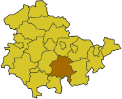
Saalfeld-Rudolstadt is a cool place in the south of Thuringia, Germany. It's like a county or a district, called a Landkreis in German.
Contents
A Look Back in Time
The area we now call Saalfeld-Rudolstadt has a long history. The first part, Saalfeld, started as a local office called a Landratsamt in 1868. It became a full district, a Landkreis, in 1922. The Rudolstadt district was also created in 1922. Later, in 1994, these two districts joined together to form the Saalfeld-Rudolstadt district we know today.
What's on the Coat of Arms?
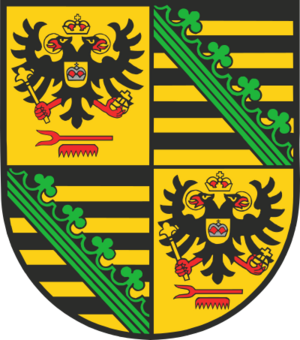
The coat of arms for Saalfeld-Rudolstadt tells a story about its past.
- Saxon Symbols: In the top-right and bottom-left parts, you can see the Saxon coat of arms. This is because Saalfeld used to be the main city of a small duchy called Saxony-Saalfeld.
- Schwarzburg-Rudolstadt Princes: The other two parts show symbols from the Princes of Schwarzburg-Rudolstadt.
- The two-headed eagle means they were important "imperial princes."
- The comb at the bottom shows that these princes were also "Imperial Stable Masters." This was a special title.
Towns and Communities
This district is home to many towns and smaller communities. They are grouped in different ways for local government.
Main Towns and Communities
These towns and communities manage their own affairs directly:
- Bad Blankenburg
- Gräfenthal
- Königsee
- Leutenberg
- Remda-Teichel
- Rudolstadt
- Saalfeld
- Altenbeuthen
- Arnsgereuth
- Drognitz
- Hohenwarte
- Kamsdorf
- Kaulsdorf
- Rottenbach
- Saalfelder Höhe
- Uhlstädt-Kirchhasel
- Unterwellenborn
Groups of Communities (Verwaltungsgemeinschaften)
Some smaller communities work together in groups called Verwaltungsgemeinschaften. This helps them share resources and manage things more easily.
1. Bergbahnregion/Schwarzatal
- Cursdorf
- Deesbach
- Katzhütte
- Lichtenhain/Bergbahn
- Meuselbach-Schwarzmühle
- Oberweißbach (This is the main town for this group, and it's also a town.)
2. Lichtetal am Rennsteig
- Lichte (This is the main town for this group.)
- Piesau
- Reichmannsdorf
- Schmiedefeld
3. Mittleres Schwarzatal
- Allendorf
- Bechstedt
- Döschnitz
- Dröbischau
- Mellenbach-Glasbach
- Meura
- Oberhain
- Rohrbach
- Schwarzburg
- Sitzendorf (This is the main town for this group.)
- Unterweißbach
- Wittgendorf
4. Probstzella-Lehesten-Marktgölitz
- Lehesten (This is a town.)
- Probstzella (This is the main town for this group.)
 | Jewel Prestage |
 | Ella Baker |
 | Fannie Lou Hamer |


