Saint-Pierre-des-Ifs, Calvados facts for kids
Quick facts for kids
Saint-Pierre-des-Ifs
|
|
|---|---|
 |
|
| Country | France |
| Region | Normandy |
| Department | Calvados |
| Arrondissement | Lisieux |
| Canton | Lisieux-3 |
| Intercommunality | Lisieux Pays d'Auge |
| Area
1
|
11.16 km2 (4.31 sq mi) |
| Population
(2006)
|
446 |
| • Density | 39.96/km2 (103.51/sq mi) |
| Time zone | UTC+01:00 (CET) |
| • Summer (DST) | UTC+02:00 (CEST) |
| INSEE/Postal code |
14648 /14100
|
| Elevation | 83–177 m (272–581 ft) (avg. 250 m or 820 ft) |
| 1 French Land Register data, which excludes lakes, ponds, glaciers > 1 km2 (0.386 sq mi or 247 acres) and river estuaries. | |
Saint-Pierre-des-Ifs is a small town, also known as a commune, located in the northwest of France. It is found in the region called Basse-Normandie, within the Calvados department. This area is known for its beautiful countryside and rich history.
Contents
What is a French Commune?
A commune in France is like a local town or village area. It is the smallest unit of local government in the country. Each commune has its own mayor and a local council that helps manage the area. They take care of things like local roads, schools, and public services for the people living there.
How Communes Work
Every commune, no matter how big or small, has a mayor who is the head of the local government. The mayor and the council are elected by the people who live in the commune. Their job is to make decisions that help the community, like planning new projects or managing local budgets. Saint-Pierre-des-Ifs is one of many communes in France.
Location and Geography
Saint-Pierre-des-Ifs is situated in the Calvados department, which is part of the Normandy region. This region is in the northwestern part of France, close to the English Channel. The commune covers an area of about 11.16 square kilometers (around 4.3 square miles).
Elevation and Landscape
The land in Saint-Pierre-des-Ifs has different heights. The lowest point is about 83 meters (272 feet) above sea level, and the highest point reaches 177 meters (581 feet). The average elevation is around 250 meters (820 feet). This varied landscape often means there are hills and valleys, typical of the French countryside.
People and Life in Saint-Pierre-des-Ifs
As of 2006, Saint-Pierre-des-Ifs had a population of 446 people. This makes it a small, quiet community. Life in a French commune like this often involves close-knit neighborhoods and a focus on local traditions. People might work in farming, small businesses, or commute to nearby larger towns for work.
Local Community
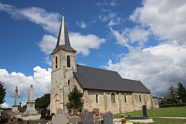
Small communes often have a strong sense of community. Residents might gather for local events, markets, or celebrations. The local church, like the one shown in the image, often serves as a central point for the community. The mayor and council work to ensure the commune remains a good place to live for its residents.
Local Government
The mayor of Saint-Pierre-des-Ifs from 2008 to 2014 was Colette Malherbe. The mayor is responsible for leading the commune's administration. They work with the intercommunality group, which for Saint-Pierre-des-Ifs is "Lisieux Pays d'Auge." This group helps different communes in the same area work together on bigger projects, like waste management or economic development.
Role of the Mayor
The mayor's role is very important. They represent the commune, manage its budget, and ensure public services run smoothly. They also act as a registrar for births, deaths, and marriages. This local leadership helps keep the community organized and running well for everyone.
See also
 In Spanish: Saint-Pierre-des-Ifs (Calvados) para niños


