Saint George, Barbados facts for kids
Quick facts for kids
Saint George
|
|
|---|---|
|
Parish
|
|

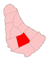
Map of Barbados showing Saint George
|
|
| Country | Barbados |
| Independence | November 30, 1966 |
| Parliamentry seats | 2 |
| Government | |
| • Type | Parliamentary democracy |
| Area | |
| • Total | 44 km2 (17 sq mi) |
| Population
(2008)
|
|
| • Total | 19,530 |
| • Density | 444/km2 (1,150/sq mi) |
| Time zone | UTC-4 (Eastern Caribbean) |
| Area code | |
| ccTLD | .bb |
| Largest town | The Glebe |
Saint George, often called "St. George," is a special area in the middle of Barbados. It's one of only two "land-locked" parishes, which means it doesn't touch the ocean. The other land-locked parish is Saint Thomas, located to the north. A famous place in Saint George is the Gun Hill Signal Station.
About Saint George
Saint George is a very central parish in Barbados. It shares its borders with six of the other eleven parishes on the island. This is more than any other parish in Barbados! The largest town in Saint George is called The Glebe.
Gun Hill Signal Station
The Gun Hill Signal Station is an important historical landmark in Saint George. It was built a long time ago, in 1818. This station is one of the few signal stations that are still standing today.
Signal stations like Gun Hill were used in the past to send messages across the island. They would use flags or lights to communicate important news, like if enemy ships were approaching or if there was a fire. It was like an old-fashioned communication network!
See also

- In Spanish: Parroquia de Saint George (Barbados) para niños
 | Frances Mary Albrier |
 | Whitney Young |
 | Muhammad Ali |

