Saint Johns, Ohio facts for kids
Quick facts for kids
Saint Johns, Ohio
|
|
|---|---|

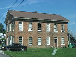
An old house in Saint Johns
|
|

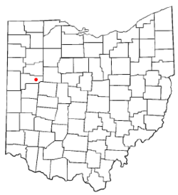
Location of Saint Johns, Ohio
|
|
| Country | United States |
| State | Ohio |
| County | Auglaize |
| Township | Union |
| Area | |
| • Total | 0.40 sq mi (1.0 km2) |
| Elevation | 1,004 ft (306 m) |
| Population
(2020)
|
|
| • Total | 304 |
| • Density | 760/sq mi (293/km2) |
| Time zone | UTC-5 (Eastern (EST)) |
| • Summer (DST) | UTC-4 (EDT) |
| Area code(s) | 419 |
| GNIS feature ID | 2628970 |
Saint Johns is a small community in Ohio, United States. It is a census-designated place, which means it's a special area defined by the government for counting people. Saint Johns is located in Auglaize County.
This community sits right on the border between two areas called Union Township and Clay Township. In 2010, about 304 people lived there. Saint Johns is found between Indian Lake and Wapakoneta. You can find it where two main roads meet: U.S. Route 33 and State Route 65. The local schools are part of the Wapakoneta City School District. The zip code for Saint Johns is 45884.
History of Saint Johns
Saint Johns was started in 1835. It was named after a person named John Rogers, who owned the land. A post office opened in Saint Johns in 1838, helping people send and receive mail.
In the middle of Saint Johns, at the corner of Center Street and Walnut Street, there is a special memorial. This memorial marks the spot believed to be the last home of Black Hoof. He was a famous leader of the Shawnee people.
See also
 In Spanish: St Johns (Ohio) para niños
 | Selma Burke |
 | Pauline Powell Burns |
 | Frederick J. Brown |
 | Robert Blackburn |

