
Saint Paul, Antigua and Barbuda facts for kids
Quick facts for kids
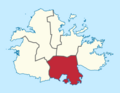
Parish of Saint Paul
|
|
|---|---|
.svg) |
|
| Country | Antigua and Barbuda |
| Established | 11 January 1692 |
| Capital | Falmouth |
| Population
(2018)
|
|
| • Total | 9,004 |
| Ethnicities | |
| • African/Black | 91.24% |
| Time zone | UTC-4 (AST) |
Saint Paul is a parish in Antigua and Barbuda. It is located in the central-southern part of Antigua island. In 2018, about 9,004 people lived there.
The main church for the parish, St. Paul's Anglican Church, is in Falmouth.
Contents
- Exploring the History of Saint Paul
- What Were the Sugar Mills?
- Barrel Beef Estate: A Community's Beginning
- Barter’s Estate: A Challenging Landscape
- Bodkin’s Estate: A Glimpse into the Past
- Buckshorne's Estate: From Sugar to Homes
- Burke's Estate: A Place of Change and Community
- Cabadge (Cabbage) Tree Plantation: Early Sugar Production
- Cherry Hill: A View and a Mystery
- Deep Bay: A Planned Transformation
- Delaps Estate: The Potworks Dam
- Dimsdale Estate: Lime Production and Rastafarian Farming
- Doig’s Estate (Rendezvous Bay): A Secluded Beauty
- Folly’s/Milly Byam’s Estate: Well-Documented History
- What Were the Sugar Mills?
- Populated Places in Saint Paul
- Demographics (2011)
- Images for kids
- See also
Exploring the History of Saint Paul
What Were the Sugar Mills?
Long ago, many areas in Saint Paul were sugar plantations. These places had mills that processed sugarcane into sugar. Let's look at some of these old estates and their stories.
Barrel Beef Estate: A Community's Beginning
The Barrel Beef Estate was once a small sugar plantation. The Fredericks family owned it until 1970. Then, the government took it over. Today, it is part of the Liberta community.
This area is believed to be the first part of Liberta where people settled. The government built the Liberta Primary School here. They also created public spaces for fun activities. A new police station and a medical center were also built on this land.
Barter’s Estate: A Challenging Landscape
Barter's Estate is near Rendezvous Bay. It was hard to reach because of the hilly land. There was a path through the hills to Howard's Estate and then to Swetes. Another dirt road leads to the beautiful Rendezvous Beach, a popular spot for visitors.
Today, only a few large stones from the old sugar mill remain. The rest of the structure has fallen apart. Historical records show that the Barter family owned this estate for many years.
Sir George Walter, a famous leader from Antigua, had a connection to this area. His father, Norris Walter, helped start the Antigua Workingmen's Association in 1932. This group worked to improve conditions for workers. Later, Sir George Walter became the second premier of Antigua and Barbuda.
Bodkin’s Estate: A Glimpse into the Past
Bodkin's Estate was a large plantation. In 2002, a grave was found here belonging to John Hawksley, who died in 1819. Old records show that many buildings, likely part of the sugar factory, were once on this hillside.
In 1943, the Bodkins property became part of Morris Looby's estate. It was later bought by the government for a land settlement program. This meant the land was divided and given to people.
An old picture from William Clark's "Ten Views in the Island of Antigua" shows workers on Bodkin's Estate. They were forced to work long hours, from morning until evening, growing sugarcane. This estate overlooked Monks Hill Military Station, which was built to protect Falmouth from attacks.
Buckshorne's Estate: From Sugar to Homes
Buckshorne's mill is located behind St. Barnabas' Church, surrounded by the village of Liberta. This estate was once a large sugar plantation. Over time, it was owned by several families, including the Tyrrells and Gilchrists.
In the 1940s and 1950s, Mr. Norman Techeira sold parts of the estate to people who wanted to build homes. This turned Buckshorne's from a sugar plantation into a busy neighborhood. The area has rich soil because it's in a valley surrounded by hills.
An interesting geological feature here is Quarry Hill, which has a lot of green limestone.
Burke's Estate: A Place of Change and Community
Burke's Estate shows signs of changing from water power to steam power for its mill. The mill itself was turned into a water storage tank. This estate was very large, covering hundreds of acres.
The Maginley family, who were important landowners, owned Burke's in the late 1800s. They were known for their social gatherings and active community life. They often rode horses and visited other estates.
The Burke family also donated land for the Moravian Church to build their second church in 1773. This church later led to the establishment of the village of Liberta. Moravian missions often included schools for children and adults, helping to spread education across the island.
In 1943, Burke's became part of the Antigua Syndicate Estates Ltd. Later, in 1955, the manager's house on the estate was destroyed by fire.
Cabadge (Cabbage) Tree Plantation: Early Sugar Production
The Cabbage Tree Plantation was an early sugar-producing estate in St. Paul's Parish. It was owned by people like Colonel William Byam and later by Samuel Wyllys and Richard Lord from Connecticut. These owners faced challenges, including financial difficulties.
The plantation was involved in early trade and land deals. It was also connected to Governor George Lucas, who governed Antigua from 1742 to 1747. The mill from this plantation can still be seen from Fig Tree Drive road, near Clairmont.
Cherry Hill: A View and a Mystery
Cherry Hill offers beautiful views over Falmouth Bay. There have been some disagreements about who owns the land here.
Deep Bay: A Planned Transformation
Deep Bay once had a windmill, but it's gone now. Cattle were raised on this land. In the 1960s, there were plans to build a hotel here, but it didn't happen. Later, it became a residential area where people live.
Delaps Estate: The Potworks Dam
Around the mid-1800s, Delaps Estate started using steam power for its sugar production. A big part of this estate was covered by water when the Potworks Dam was built in 1968. This dam created Antigua's first lake, which can hold a billion gallons of water!
The dam was built to provide water for the island. When the dam is full, the old road that used to go through the Delaps mill ruins is underwater. The area around the dam became a popular spot for recreation, but the government stopped this to protect the water supply.
Dimsdale Estate: Lime Production and Rastafarian Farming
Dimsdale Estate was known for producing limes. Workers would grate lime skin to make valuable oil and then crush the limes for juice. This continued until about 1948.
Today, Rastafarians use the land around the old mill to grow fruits and vegetables. The area is known for its beautiful scenery.
Doig’s Estate (Rendezvous Bay): A Secluded Beauty
Doig's Estate is in a stunning location near Rendezvous Bay, but it used to be quite isolated due to the hills. It's often called the Rendezvous Bay Estate. Today, a road through Spring Hill Riding Stables provides access to the natural Rendezvous Beach.
Historical records show that the Doig family owned this estate. It was known for its very fertile land, which could produce a lot of sugarcane. The cane was transported by donkeys and then by trucks to the railway for shipment to the sugar factory.
Folly’s/Milly Byam’s Estate: Well-Documented History
The Folly Estate has interesting ruins, including a hexagonal brick entrance to the old house. The mill is still in good condition. This estate has a lot of historical information because the Byam family kept good records.
Edward Byam, who was Lieutenant Governor of Antigua and Governor of the Leeward Islands, owned this estate in the 1700s. Detailed records from 1778 describe the land, workers, animals, and buildings on the Folly and Savanna plantations. These records show the different parts of the estate, like the corn mill, dwelling house, and blacksmith's shop.
Populated Places in Saint Paul
The main city in the parish is Falmouth. Other towns and villages include:
- Bethesda
- Burkes
- Christian Hill
- Cobbs Cross
- Delaps
- Dow Hill
- English Harbour
- Liberta
- Marsh Village
- Mathews
- Pattersons
- Piccadilly
- Swetes
- Tyrells
Fort Berkeley is also located in the parish, within the Nelson's Dockyard national park at Falmouth Harbour.
Demographics (2011)
This section shows information about the people living in Saint Paul in 2011.
What are the Ethnicities of the People?
| Ethnic Group | Number of People | Percentage |
|---|---|---|
| African descendent | 7,405 | 91.24% |
| Caucasian/White | 285 | 3.52% |
| East Indian/India | 27 | 0.33% |
| Mixed (Black/White) | 50 | 0.61% |
| Mixed (Other) | 163 | 2.01% |
| Hispanic | 73 | 0.90% |
| Other | 62 | 0.76% |
| Don't know/Not stated | 51 | 0.63% |
| Total | 8,116 | 100.00% |
Where are People Citizens Of?
| Country of Citizenship | Number of People | Percentage |
|---|---|---|
| Antigua and Barbuda | 7,041 | 86.76% |
| Other Caribbean countries | 38 | 0.47% |
| Canada | 10 | 0.12% |
| Other Asian and Middle Eastern countries | 13 | 0.16% |
| Dominica | 93 | 1.15% |
| Dominican Republic | 39 | 0.48% |
| Guyana | 221 | 2.72% |
| Jamaica | 301 | 3.71% |
| Monsterrat | 10 | 0.12% |
| St. Lucia | 12 | 0.14% |
| St. Vincent and the Grenadines | 25 | 0.31% |
| Trinidad and Tobago | 6 | 0.08% |
| United Kingdom | 100 | 1.23% |
| USA | 98 | 1.20% |
| Other countries | 59 | 0.73% |
| Not Stated | 50 | 0.61% |
| Total | 8,116 | 100.00% |
What About Second Citizenships?
| Country of Second Citizenship | Number of People | Percentage |
|---|---|---|
| Other Caribbean countries | 94 | 9.36% |
| Canada | 28 | 2.73% |
| Other Asian and Middle Eastern countries | 2 | 0.21% |
| Dominica | 93 | 9.25% |
| Dominican Republic | 18 | 1.79% |
| Guyana | 159 | 15.77% |
| Jamaica | 108 | 10.73% |
| Monsterrat | 17 | 1.68% |
| St. Lucia | 15 | 1.47% |
| St. Vincent and the Grenadines | 28 | 2.73% |
| Trinidad and Tobago | 17 | 1.68% |
| United Kingdom | 149 | 14.72% |
| USA | 236 | 23.34% |
| Other countries | 46 | 4.52% |
| Total | 1,009 | 100.00% |
Where Were People Born?
| Country of Birth | Number of People | Percentage |
|---|---|---|
| Africa | 23 | 0.29% |
| Other Latin or North American countries | 20 | 0.25% |
| Antigua and Barbuda | 6,162 | 75.92% |
| Other Caribbean countries | 55 | 0.68% |
| Canada | 23 | 0.29% |
| Other Asian countries | 17 | 0.21% |
| Other European countries | 54 | 0.67% |
| Dominica | 174 | 2.14% |
| Dominican Republic | 58 | 0.72% |
| Guyana | 407 | 5.02% |
| Jamaica | 404 | 4.98% |
| Monsterrat | 28 | 0.34% |
| St. Kitts and Nevis | 30 | 0.37% |
| St. Lucia | 34 | 0.42% |
| St. Vincent and the Grenadines | 48 | 0.59% |
| Trinidad and Tobago | 23 | 0.29% |
| United Kingdom | 166 | 2.04% |
| USA | 259 | 3.19% |
| USVI United States Virgin Islands | 55 | 0.68% |
| Not Stated | 75 | 0.93% |
| Total | 8,116 | 100.00% |
What are the Religions Practiced?
| Religion | Number of People | Percentage |
|---|---|---|
| Adventist | 1,136 | 14.07% |
| Anglican | 1,125 | 13.93% |
| Baptist | 291 | 3.60% |
| Church of God | 281 | 3.48% |
| Evangelical | 132 | 1.63% |
| Jehovah Witness | 135 | 1.67% |
| Methodist | 805 | 9.97% |
| Moravian | 1047 | 12.97% |
| Nazarene | 147 | 1.83% |
| None/no religion | 407 | 5.05% |
| Pentecostal | 807 | 10.00% |
| Rastafarian | 106 | 1.31% |
| Roman Catholic | 389 | 4.82% |
| Weslyan Holiness | 622 | 7.70% |
| Other | 254 | 3.14% |
| Don't know/Not stated | 389 | 4.82% |
| Total | 8,074 | 100.00% |
Images for kids
-
Map showing Saint Paul in Antigua and Barbuda.
See also
 In Spanish: Parroquia de Saint Paul (Antigua y Barbuda) para niños
