
Sak tzʼi (Maya site) facts for kids

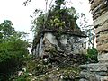
Structure in the North Acropolis
|
|

Location in Chiapas

Location in Mexico
|
|
| Location | Nueva Palestina, Chiapas, |
|---|---|
| Region | Chiapas |
| Coordinates | 16°47′06″N 91°16′48″W / 16.7850°N 91.2799°W |
| History | |
| Founded | Early Classic |
| Abandoned | 1100 CE |
| Periods | 50 CE to 1100 CE |
| Cultures | Maya |
| Site notes | |
| Excavation dates | 2003–2012 |
| Archaeologists | Luis Alberto Martos López |
| Architecture | |
| Architectural styles | Early to Late Classic Maya |
| Restored by INAH (2008–2012) Responsible body: INAH | |
Sak tzʼi is an ancient Maya city. It is an archaeological site from the time before Christopher Columbus arrived in the Americas. You can find it in the state of Chiapas, Mexico. This site is special because it has the oldest city remains in its region. It also has a unique ancient theater used by important people. Experts are still debating its true ancient name.
Contents
What's in a Name?
The modern name, Sak tzʼi, comes from a nearby community. That community was named after a place called Plan de Ayutla. Archaeologists think Plan de Ayutla is very likely the ancient city of Sak Tzʼiʼ. This name means "White Dog." Another idea is that the site could be the ancient Akʼe, which means "Turtle."
Where is Sak tzʼi Located?

Sak tzʼi is in the Upper Usumacinta area. It is about 3.5 kilometers (2.2 miles) from a small town with the same name. The site sits in the mountains of the Lacandon Jungle. This area is called the Sierra de Jalapa. Sak tzʼi is part of the Ocosingo area in Chiapas, Mexico. It is close to the border with Guatemala. It is also about 35 kilometers (22 miles) northwest of Bonampak, another famous Maya site.
What Was Its Ancient Name?
Archaeologists believe Plan de Ayutla might be one of two ancient cities. These cities are known from writings found at other sites. They are called Ak'e or Sak Tz'i'. So far, there is no clear proof to say for sure which one it is.
Why it Might be Sak Tz'i'
Luis Alberto Martos López, an archaeologist, thinks it is more likely Sak Tz'i'. He notes that ancient Sak Tz'i' fought wars with other big Maya cities. These included Yaxchilan, Bonampak-Lacanha, Tonina, and Piedras Negras. Plan de Ayutla is located right in the middle of all these places.
Martos also points out that the last writing from this region is from 854 CE. It mentions Sak Tz'i'. At that time, people were still living and building at Plan de Ayutla. Also, some stolen stone carvings from the area were found. They show a lord of Sak Tz'i' called a "Ballplayer." This title makes sense if Sak Tz'i' was Plan de Ayutla. That's because Plan de Ayutla has the biggest ballcourt in the region.
Sak Tz'i' had strong connections with Piedras Negras. The North Acropolis at Plan de Ayutla looks very much like the Grand Acropolis at Piedras Negras. This could mean they were important allies.
Why it Might be Ak'e
The idea for Ak'e suggests that the rulers of Bonampak might have come from somewhere else. They might have come from Plan de Ayutla. This would explain why Plan de Ayutla shares building styles with Tonina. Tonina was a powerful city that ruled Bonampak. For example, the ballcourt layout, stone altars, and roof decorations on Structure 13 are similar.
However, some archaeologists disagree. They note that Plan de Ayutla's buildings with two galleries are like those in nearby Ojo de Agua and Nuevo Jalisco. But they are different from Bonampak and Lacanha. These differences might mean they were separate kingdoms.
In 2020, researchers found the capital of the Sak Tz’i’ kingdom. It is now called Lacanjá Tzeltal. This discovery was made in the backyard of a Mexican farmer in Chiapas. The team also found "Plaza Muk’ul Ton," or Monuments Plaza. This was a place where people gathered for ceremonies.
A Look at Sak tzʼi's Past
The oldest buildings at Sak tzʼi date back to about 150 BCE. But a city settlement appeared around 50 BCE. An ancient living area found here is from 50 BCE to 50 CE. This makes Plan de Ayutla the earliest city found in the Upper Usumacinta region so far.
If Sak tzʼi was indeed Sak Tzʼiʼ, its history was full of conflict. The region was very unstable between 600 and 800 CE. A stone carving from Piedras Negras shows Lord Kʼabʼ Chan Teʼ of Sak Tzʼiʼ being captured in 628 CE.
Rulers and Conflicts
There are different ideas about what happened next. One idea is that Kʼabʼ Chan Teʼ survived. He then became a loyal helper to Piedras Negras. He helped them fight Bonampak and La Mar in 641 CE. Another idea is that Kʼabʼ Chan Teʼ survived and fought back. He defeated Piedras Negras, Bonampak, and La Mar. It's also possible that the Kʼabʼ Chan Teʼ mentioned in 641 CE was a different ruler with the same name. This name was common among Sak Tzʼiʼ rulers. Either way, Sak Tzʼiʼ controlled a large area in the 600s. This area stretched from La Mar to Bonampak.
Aj Sak Maax ruled Sak Tzʼiʼ from the 750s until at least 772 CE. During his rule, the city of El Cayo seemed to be under both Sak Tzʼiʼ and Piedras Negras. This means Sak Tzʼiʼ was either an ally or a helper of Piedras Negras. And Piedras Negras, in turn, ruled El Cayo.
By 787 CE, Aj Sak Maax was no longer king. Yeteʼ Kʼinich of Sak Tzʼiʼ had two of his lords captured. This seems to have been a rebellion by Bonampak, helped by Yaxchilan. These events are shown in the famous paintings at Bonampak. After 789 CE, Tonina attacked Jatsʼ Tokal Ekʼ Hiix. He was the ruler of Sak Tzʼiʼ at that time.
The City's End
Around 800–850 CE, new types of pottery appeared at Plan de Ayutla. These ceramics are linked to the Chontal people. Around 850 CE, Plan de Ayutla seems to have been ruled by a council, called a multepal. This was happening in other cities too. The destruction of the council's main building might mean a new group tried to take power. The last writing from the region, from 864 CE, mentions a helper of another Kʼabʼ Chan Teʼ of Sak Tzʼiʼ. The new rulers must have failed. The city was violently abandoned between 1000 and 1100 CE.
Rulers of Sak Tzʼiʼ
| Name | Dates |
|---|---|
| U Kʼabʼ | around. 564 |
| Kʼabʼ Chan Teʼ I | around. 594–641 |
| Kʼabʼ Chan Teʼ II? | around.653–693 |
| Aj Sak Maax | around.754–772 |
| Yehtʼ Kʼinich | around. 787 |
| Jatsʼ Tokal Ekʼ Hiix | around.796? |
| Kʼabʼ Chan Teʼ III | around. 864 |
Source: Archaeologists' findings
Modern Discoveries
The Lacandon people have known about this site for a long time. In 1975, archaeologist Peter Schmidt was led to Plan de Ayutla by them. He wrote the first report about the site. Archaeologists didn't pay much attention to it until 1994. Then, Alejandro Tovalin visited it again. In 2001, the local community started clearing the jungle around the site. They hoped to attract tourists and asked archaeologists to visit. This led to more visits and formal digs starting in 2003. Luis Alberto Martos López led these digs. Tovalín had only reported on the North Acropolis. But in 2004, Martos realized there were three main acropolises.
Restoration work began in 2008. It focused on the North Acropolis and the Ballcourt. The goal was to open the site to the public in 2012.
Exploring the Site
The entire site covers about 24 hectares (0.09 square miles). But the main part is only one-third of that. There are 72 buildings spread across the site. The heart of the city was built around three natural hills. These hills were shaped into three large platforms called acropolises. The areas between and around them became three main plazas. These plazas were used for public and religious events. These three main plazas can be divided into seven smaller ones. The best-preserved buildings are on the acropolises. The plazas are surrounded by piles of broken stone and dirt.
The buildings here share features with other Maya sites. These include Yaxchilan, Palenque, Lacanha, and Bonampak. But Sak tzʼi also has its own unique parts. A key example is Structure 13 on the North Acropolis.
The site was heavily looted, which means many structures were damaged. All the tall stone monuments (stelae) have been removed. It's unusual that there are no writings found at the site itself.
The West Plaza
This plaza is split into two parts by two steps and a rectangular building.
- Plaza Ajkʼol ("Upper" in the Tzeltal language) is a sunken area. It is between the North and West Acropolises. Five buildings are to its northwest. Plaza Yolil is to its southeast.
- Structure 18 is a long, narrow terrace. It is at the bottom of the West Acropolis, above Plaza Ajkʼol. It might have been a wall or a path for parades.
- Plaza Yolil ("Central") is also bordered by the same Acropolises. A ballcourt (Structure 39) is to its southeast. This ballcourt separates it from Plaza Alan.
- Structure 39 is between Plaza Yolil and Plaza Alan. It is the largest ballcourt found in the Upper Usumacinta area. It has six buildings and is 65 meters (213 feet) long. It is similar to the ballcourt at Tonina. Instead of markers in the middle, it has a single column. Structure 39 is at the center of the site. It is between the three acropolises and the three plazas. This shows how important it was.
The Central and East Plazas
A large plaza sits in the center of the site. It has two separate areas named in Tzeltal: Alan (Lower) and Mukuʼl (Great). Mukuʼl is between the North and East Acropolises. South of Plaza Alan are Plazas Tut (Small) and Bejaʼ (of the Arroyo or stream). The latter is named after a small valley that crosses it. Plaza Tonnaʼ (of the Stone Houses) extends northeast from Plaza Mukuʼl. It has four groups of homes around it.
The North Acropolis
The North Acropolis is like a Maya Palace. It has homes for important people, temples, and meeting places. It was built on a natural hill that was changed to fit the buildings. The hill is 45 meters (148 feet) high. At least 19 buildings were put on it. On the north side, four buildings rise on terraces. This makes the acropolis look like the one at Piedras Negras. Fine pottery and other items found here show that people lived here through the Late Classic period.
In 2012, a theater was found here. It dates from around 800–900 CE. A courtyard surrounded by buildings from 250–500 CE was changed to make room for three wide rows of seats. An outer wall of another building was torn down to create a stage. It was likely for a small group of up to 120 important people. The theater might have been built to help a new ruling family gain power around 850 CE. In the same building, a bath for an elite person was found. It even had a drainage system! It is one of only four such baths found in Mexico from ancient times. The others are at Palenque, Tonina, and Teotihuacan. Pottery used to hold water for the bath was found in a nearby room.
Also, in 2011, older courtyard remains were found under later buildings. These date from 50 BCE to 50 CE. These types of buildings were not found at other sites in the region until about 250 CE. The buildings have rounded corners, which is a sign of early Maya architecture. Most of the upper parts of these buildings were torn down. The rubble was used to fill the older structures to build newer ones.
- On the south side, Structures 1, 2, and 3 stand tall. All three had arched roofs, a narrow entrance, and three inner rooms. They look similar to buildings in Palenque.
- Structure 4 is on the second terrace from the top. It was built around 800 CE. Metal cooking tools from 900–1000 CE were found here. This makes archaeologists think it was a kitchen or pantry. Two burials from the same time were found nearby in a changed staircase. One was a woman buried with clay figures and cooking tools.
- Structure 6 was an L-shaped building with two temples at its ends. It seems to have been the meeting place for the ruling council. This council likely governed the site for some time. Later, it was walled in.

- Structure 13 is a very special building from the Early Classic period. It has one of the tallest arched ceilings found in the Maya world, measuring 8 meters (26 feet) high. It was painted black inside, which is rare for Maya buildings. The outside of the roof has unique stepped patterns. Also, two extra rooms were found above the main rooms. These might have been a second story or extra support. Drawings on the building show a throne, a lord, and the building itself. This makes archaeologists think it was the home of the ruler of Plan de Ayutla. Thanks to special openings, three rectangles of light appear on the ceiling of Structure 13 in mid-July. This marks the start of the farming season.
The East Acropolis
This acropolis was also built on a shaped natural hill. It has four buildings around a central plaza. Archaeologists think a staircase once went down to the southeast, towards Plaza Tut. A burial was found at the bottom of this possible stairway. It contained fine pottery from the Late Classic period. The exact purpose of this complex is not clear. But the huge Structure 58 suggests it was for living. A looted tomb suggests it was also used for burials.
- Structure 58 is the largest building on the East Acropolis. It is on the southwestern side of the plaza. It was probably a very large building with an arched roof. It may have been a home.
The West Acropolis
This is the tallest acropolis. It was built into a ridge that extends from the southwest. The ridge is 65 meters (213 feet) tall at the ruins. The small spaces here make archaeologists believe it was used by a select group of important people. The type of buildings suggests it was used for religious purposes.
- Structure 25 is a large temple built on a cross-shaped platform. The inner sacred room had another gallery built around it later. This makes it similar to the temples of the Cross Group in Palenque.
- Structure 26 was a large stepped platform. It was reached from the north by a staircase that is no longer there. A ruined temple was on top of it.
- Structure 27 is a rectangular building with three entrances.
- Structure 31 is the highest point at the site. It has the only writings found so far at the site. It is a single-room building on a three-stepped platform. The base and sides of the building were once decorated with stucco carvings. These are now badly worn. But some parts of writing can still be seen. The western side had the most complete symbols. But experts have not been able to read them yet. Experts think they are in an early style of writing from the Early Classic (around 375 CE). It has been nicknamed the Temple of Inscriptions.
- Structure 32 was a stepped platform with five levels. It had a staircase and a temple on top.
Images for kids
-
Structure in the North Acropolis
-
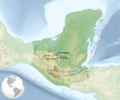
A map showing the location of Sak tzʼi (Plan de Ayutla) among other Maya cities.
-
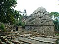
Structure 13, with Structure 1 in the background. Notice the unique roof decoration.
See also
 In Spanish: Sak tz'i (zona arqueológica) para niños
