Salado River (Buenos Aires) facts for kids

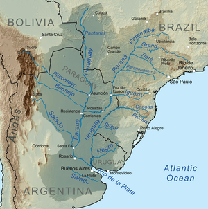
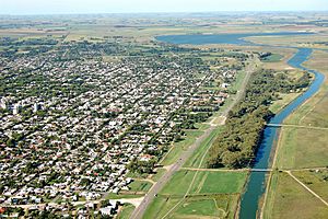
The Salado River (which means Salty River in Spanish) is an important river in the northern part of Buenos Aires Province, Argentina. It starts at El Chañar Lake, near the border with Santa Fe Province. This starting point is about 40 meters (130 feet) above sea level. The river flows mostly southeast for about 640 kilometers (400 miles). It finally empties into Samborombón Bay, which is part of the Río de la Plata estuary (where a river meets the sea) on the Atlantic Ocean. The end of the Salado River is about 170 kilometers (105 miles) south of the city of Buenos Aires.
The area that the Salado River collects water from is called its "drainage basin." This basin is very large, covering about 170,000 square kilometers (65,600 square miles). This is more than half of Buenos Aires Province! The region gets a lot of rain, about 2,000 millimeters (79 inches) each year. This often causes floods in the low-lying areas. The river flows past cities like Junín, Roque Pérez, and General Belgrano. It also passes many wetlands and lakes. Engineers have worked to make the lower part of the river deeper and wider. This helps the water flow better, about 88 cubic meters (3,100 cubic feet) per second. Nearly 1 million people live in this river basin.
Because Argentina has another, larger river also called Salado in the northern part of the country, this river is sometimes called Salado del Sur. This means "Southern Salado."
History of the Salado River
In the 1800s, before a time known as the Conquest of the Desert, the Salado River was very important. It served as a border between the lands controlled by the Spanish settlers and the lands still controlled by the native peoples.
See also
 In Spanish: Río Salado (Buenos Aires) para niños
 | Misty Copeland |
 | Raven Wilkinson |
 | Debra Austin |
 | Aesha Ash |


