Samborombón Bay facts for kids
Quick facts for kids Samborombón Bay |
|
|---|---|

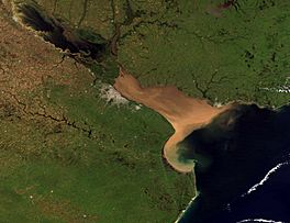
Visible as a C-shaped indentation in the coast near the southern end of the Río de la Plata estuary
|
|
| Location | South America |
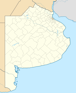
| Coordinates | 35°54′S 57°05′W / 35.900°S 57.083°W |
| Native name | Bahía de Samborombón (Spanish) |
| River sources | Salado River, Samborombón River |
| Ocean/sea sources | Argentine Sea, South Atlantic Ocean |
| Basin countries | Argentina |
| Max. width | 135 km (84 mi) |
| Surface area | 2,500 km2 (970 sq mi) |
| Settlements | General Lavalle, San Clemente del Tuyú |
| Official name: Bahía de Samborombón | |
| Designated: | 24 January 1997 |
| Reference #: | 885 |
Samborombón Bay, also known as Spanish: Bahía de Samborombón in Spanish, is a large bay located on the coast of Buenos Aires Province in Argentina. It sits right where the huge Río de la Plata meets the Argentine Sea. This bay starts about 160 kilometers (100 miles) southeast of the city of Buenos Aires. It stretches for about 135 kilometers (84 miles) across.
Contents
How Samborombón Bay Got Its Name
People believe the bay was named way back in 1520. This happened during the expedition of Ferdinand Magellan. The explorers thought the bay's curved shape looked like the legendary Saint Brendan's Island had broken off from the mainland. "Samborombón" is a changed version of "San Borondón," which was the name of that mythical island. The Samborombón River and the town of Samborombón also share this unique name.
Where is Samborombón Bay?
Samborombón Bay is found at the mouth of the Río de la Plata. It stretches from a place called Punta Piedras in the north down to Punta Rasa in the south. This is where Cape San Antonio begins.
Sometimes, people think of the bay as part of the Río de la Plata's estuary. Other times, it's seen as a big bay of the Argentine Sea. The International Hydrographic Organization says the Río de la Plata ends at a line between Punta del Este, Uruguay, and Cape San Antonio, Argentina. This means Samborombón Bay is included as part of the river.
Water Flow in the Bay
Many rivers and streams flow into Samborombón Bay. The main ones are the Southern Salado River and the Samborombón River. There are also many man-made canals that help drain water from the eastern part of Buenos Aires Province. A lot of water also flows out of the Río de la Plata and into the Argentine Sea through this bay.
Protecting Nature in the Bay
Samborombón Bay is a very special place for wildlife. Many different kinds of shorebirds visit the bay. They use it as an important stopping point during their long seasonal migrations. The bay is also a crucial "nursery" area for young fish. These fish grow up here before moving into the larger Río de la Plata system.
Because of its importance, the bay and its nearby coast are part of several protected areas. These areas help protect the well-preserved Pampas grasslands and wetlands found here.
- The central part of the coast is called the Samborombón Bay Provincial Nature Reserve. It's a safe place for many animals.
- Parts of the southern coast are in the Rincón de Ajó Provincial Nature Reserve.
- The bay is also recognized internationally as a Western Hemisphere Shorebird Reserve Network Site.
- It's a Ramsar Wetland of International Importance. This means it's super important for birds like the buff-breasted sandpiper.
- The southern shore includes Campos del Tuyú National Park. This park is home to a group of rare Pampas deer.
Fun Activities at the Bay
The coast of Samborombón Bay is famous for its excellent sport fishing. Many people enjoy fishing in the waters near Punta Rasa and the town of General Lavalle. You can catch large saltwater fish there, like the black drum.
See also
 In Spanish: Bahía de Samborombón para niños
 | William Lucy |
 | Charles Hayes |
 | Cleveland Robinson |


