
Río de la Plata Basin facts for kids
Quick facts for kids Río de la Plata Basin |
|
|---|---|
| Platine Region | |

The southern Platine region viewed from space, with the Río de la Plata at the lower-right
|
|

Map of the Río de la Plata basin in South America, with major cities and rivers marked
|
|
| Location | South America |
| Coordinates | 32°15′S 59°30′W / 32.250°S 59.500°W |
| Area | 3,170,000 square kilometres (1,220,000 sq mi) |
| Major rivers | Río de la Plata, Paraná River, Uruguay River, Paraguay River |
The Río de la Plata Basin is a huge area in South America. It's also known as the River Plate Basin or Platine Region. Think of it as a giant funnel that collects all the water from many rivers and sends it to the Río de la Plata. This river then flows into the Atlantic Ocean.
This basin covers about 3.17 million square kilometers (1.22 million square miles). That's a massive area! It includes parts of Bolivia, Brazil, all of Paraguay, most of Uruguay, and northern Argentina. It makes up about one-fourth of South America. It's the second largest river basin on the continent, right after the Amazon Basin. It's also one of the biggest in the whole world.
The most important rivers in this basin are the Paraná River, the Paraguay River, and the Uruguay River. These rivers are like the main highways for water in the region.
Contents
Exploring the Geography of the Río de la Plata Basin
The Río de la Plata Basin is surrounded by some impressive natural features. To the north, you'll find the Brazilian Highlands. To the west, there are the towering Andes Mountains. And to the south, it borders Patagonia.
The basin stretches far to the north from where the Río de la Plata begins. It goes for about 2,400 kilometers (1,500 miles). This huge area reaches cities like Brasília and Cuiabá in Brazil, and Sucre in Bolivia. It covers a wide range of latitudes and longitudes. The Paraná River is the largest river flowing into the La Plata. It's the second longest river in South America and one of the longest globally.
Countries and Regions in the Basin
Many different areas are part of this basin. In Brazil, it includes states like Mato Grosso, Goiás, and São Paulo. In Bolivia, it covers departments such as Santa Cruz and Chuquisaca. The entire country of Paraguay is within the basin. Most of Uruguay's western and central regions are also part of it. Finally, in Argentina, many provinces like Jujuy, Salta, and Buenos Aires are included.
How Water Flows in the Río de la Plata Basin
All the rain that falls in this vast area eventually makes its way to the Río de la Plata. Most of this water travels through the Paraná River, the Paraguay River, and the Uruguay River. These are the main rivers that feed the La Plata.
The Río de la Plata releases a huge amount of water into the Atlantic Ocean. On average, it's about 22,000 cubic meters (776,923 cubic feet) of water per second! Most of this water comes from the Paraná River.
The Guarani Aquifer and Silt
The basin is also important because it helps refill the Guarani Aquifer. This is one of the world's largest underground water systems. The rivers in the La Plata Basin carry a lot of silt (fine dirt and sand) into the Río de la Plata every year. This makes the water muddy. Ships need clear paths, so the shipping routes are kept open by constantly dredging (removing silt from the bottom).
Main Rivers and Their Branches
The Paraná River has many important branches, called tributaries. These include the Paranaíba River, Grande River, Tietê River, and Iguazu River. After collecting water from these, the Paraná ends in a large area of channels and islands called the Paraná Delta.
The Paraguay River flows through a huge wetland called the Pantanal. Its main tributaries are the Pilcomayo River and the Bermejo River. The Uruguay River also has its own tributaries, like the Pelotas River and the Río Negro. Another important river flowing into the Río de la Plata is the Salado del Sur River.
A Look at the History of the Platine Region
The Río de la Plata Basin has seen many conflicts throughout history. This is because the area was often a disputed border between the Portuguese Empire and the Spanish Empire in South America. Later, the countries that became independent from these empires also fought over the land. Many wars were fought here, especially in the 1800s.
Early Explorers Arrive
An explorer named Sebastian Cabot was one of the first to study the Río de la Plata and its rivers in detail. He even gave the river its modern name. Between 1526 and 1529, he explored the Paraná and Uruguay rivers. He traveled up the Paraná as far as where the city of Asunción is today. He also explored up the Paraguay River. Cabot traded with the Guarani people near Asunción and got silver trinkets. These silver items led to the name Río de la Plata, which means "river of silver."
Colonial Times
The first European settlement in this region was the city of Buenos Aires. It was founded by Pedro de Mendoza in 1536. However, this settlement didn't last long and was soon abandoned. Because they couldn't establish a lasting settlement there, explorers moved further upriver. This led to the founding of Asunción in 1537. Buenos Aires was later refounded by Juan de Garay in 1580.
For a long time, the Spanish Empire didn't pay much attention to the Platine Basin. But in the 1760s, Portugal and Britain started showing interest in expanding into the area. To protect their claims, the Spanish created a new government area called the Viceroyalty of the Río de la Plata in 1776. During the Napoleonic Wars, Spain sided with France. This led to the British trying to invade the region in 1806–1807, but they were not successful.
The Time of Revolutions
After the Spanish and Portuguese colonies gained their independence in the early 1800s, conflicts in the region grew even more. Countries fought over land and the right to use the rivers for trade. Many wars were fought over these issues throughout the 19th century. These included the Argentine Civil Wars, the Cisplatine War, the Platine War, and the Paraguayan War.
Economic Importance: Dams and Power
The Río de la Plata Basin is home to many important hydroelectric dams. These dams use the power of flowing water to create electricity.
Major Dams in the Basin
- Itaipu: This is the second largest operating hydroelectric facility in the world! It's shared by Paraguay and Brazil on the Paraná River.
- Ilha Solteira Dam: Located in Brazil on the Paraná River, it's the 21st largest.
- Yacyretá Dam: Shared by Paraguay and Argentina, also on the Paraná River, it's the 25th largest.
- Itumbiara Dam: In Brazil, on the Paranaíba River, it's the 53rd largest.
Other important dams include:
- On the Paranaíba River in Brazil: Emborcação and São Simão.
- On the Paraná River in Brazil: Engineer Souza Dias and Engineer Sérgio Motta.
- On the Grande River in Brazil: Água Vermelha, Furnas, Peixotos, Marimbondo, Luiz Barreto, Jaguara, and Volta Grande.
- On the Iguazu River in Brazil: Bento Munhoz, Ney Braga, José Richa, Salto Santiago, and Salto Osório.
- On the Pelotas River in Brazil: Machadinho Hydroelectric Power Plant.
- On the Uruguay River: The Salto Grande Dam is shared by Uruguay and Argentina. The Itá Hydroelectric Power Plant is in Brazil.
- On the Negro River in Uruguay: Rincon del Bonete (a reservoir), Baygorria, and Constitucion dams.
Culture of the Platine Region
The way people speak Spanish in the lower Río de la Plata Basin is unique. It's called Rioplatense Spanish, named after the river itself. This region is also famous as the birthplace of the tango dance and music, which are loved around the world!
Images for kids
-
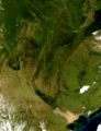
The southern Platine region viewed from space, with the Río de la Plata at the lower-right
-
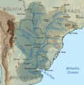
Map of the Río de la Plata basin in South America, with major cities and rivers marked
See also

