Salamat (region) facts for kids
Quick facts for kids
Salamat
|
|
|---|---|

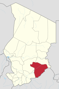
Map of Chad showing Salamat.
|
|
| Country | Chad |
| Departments | 3 |
| Sub-prefectures | 9 |
| Regional capital | Am Timan |
| Population
(2009)
|
|
| • Total | 302,301 |
Salamat is one of the 23 regions in the country of Chad. It is located in the southeastern part of Chad. The main city and capital of the region is Am Timan. Salamat used to be known as a "prefecture" with the same name.
Contents
Discovering Salamat's Geography
Salamat shares its borders with other regions. To the north, it touches the Sila Region. To the southeast, it borders the Central African Republic. On its western and northwestern sides, it is next to the Moyen-Chari Region and Guéra Region.
The land in Salamat is mostly flat. It is covered by a type of grassland called savannah. A large part of the famous Zakouma National Park is found within this region. This park is home to many wild animals.
Major Towns and Cities
The biggest city and the capital of the Salamat region is Am Timan. Other important towns in the region include Abgué, Abou-Deïa, Am Habilé, Djouna, Haraze, Mangueigne, and Mouraye.
People and Languages in Salamat
In 2009, a count of the population showed that 302,301 people lived in Salamat. Many different groups of people live here.
Some of the main groups are:
- Arab groups: These include the Baggara people. They often speak a language called Chadian Arabic.
- Gula groups: These include people who speak languages like Gula Iro and Bon Gula.
- Other groups: People also speak languages such as Jonkor Bourmataguil, Kibet, Runga, and Toram.
Economy and Daily Life
The way people make a living in Salamat is mainly through subsistence agriculture. This means they grow food mostly for themselves and their families. Fishing is also an important activity. Growing cotton is another part of the economy.
Some organizations, like the World Bank and the International Monetary Fund, have described Salamat as a very challenging region economically. There is also a small amount of tourism, mostly linked to visiting the Zakouma National Park.
How Salamat is Organized
The Salamat region is divided into three smaller areas called departments. Each department has its own main town, which is called its capital.
Here are the departments and their main towns:
| Department | Capital | Sub-prefectures |
|---|---|---|
| Aboudeïa | Aboudeïa | Aboudeïa, Abgué, Am Habilé |
| Barh Azoum | Am Timan | Am Timan, Djouna, Mouraye |
| Haraze-Mangueigne | Haraze | Haraze, Mangueigne, Daha |
See also

- In Spanish: Región de Salamat para niños
 | Selma Burke |
 | Pauline Powell Burns |
 | Frederick J. Brown |
 | Robert Blackburn |

