
Salween River facts for kids
Quick facts for kids Salween |
|
| Nujiang | |
| River | |
 Salween River forming the boundary between Burma and Thailand
|
|
| Countries | China, Burma, Thailand |
|---|---|
| State | Yunnan |
| Region | Tibet |
| Tributaries | |
| - left | Moei River |
| City | Mawlamyaing |
| Source | Qinghai Mountains |
| - elevation | 1,578 m (5,177 ft) |
| Mouth | Andaman Sea |
| - location | Mawlamyaing, Burma |
| - elevation | 0 m (0 ft) |
| Length | 2,815 km (1,749 mi) |
| Basin | 324,000 km² (125,097 sq mi) |
| Discharge | |
| - average | 1,614 m³/s (56,998 cu ft/s) |
The Salween River is a very long and important river in Southeast Asia. It flows through parts of China, Burma, and Thailand. The river is about 2,815 kilometers (1,749 miles) long. It starts high up in the mountains and ends in the Andaman Sea.
Contents
The Journey of the Salween River
The Salween River begins its long journey in the Qinghai Mountains in Tibet, China. This area is very high up, like the roof of the world! At first, the river flows west, but then it makes a big turn. It starts flowing east and then south.
Where the River Flows
As the Salween River travels south, it passes through different countries.
- In China, it is known as the Nujiang River. It carves out deep valleys and gorges.
- Then, it flows into Myanmar (Burma). Here, it's called the Thanlwin River.
- For a part of its journey, the Salween River forms the border between Myanmar and Thailand.
- Finally, the river reaches the Andaman Sea near a city called Mawlamyaing in Myanmar. This is where the river's journey ends.
Importance of the River
The Salween River is very important to the people who live along its banks. It provides water for drinking and farming. Many people also use the river for fishing. The river's path through different countries means it connects many communities.
Related pages
Images for kids
-
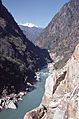
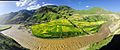
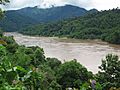
Salween River near Bingzhongluo, Yunnan
-
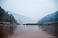
Salween River at the boundary between Burma and Thailand
-
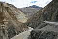
Salween (Gyalmo Nagqu) river in Tibet
-
Salawin National Park in Thailand
-
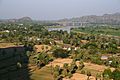
Salween River at Myaing Ka Lay, Burma
-
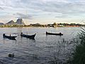
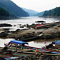
Fishing boats in the Salween River, Hpa-An
-
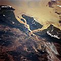
Aerial view of the Salween Delta (North is to the right). This area has been home to Mon people for at least 5,000 years.
-
Salween (Nagqu) in Biru County, Tibet
-
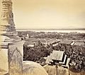
Moulmein during British rule, around 1870. View of Salween river in the distance.
-
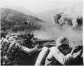
Chinese troops battle the Japanese along the Salween River in Burma, 1944
-
Salween on the border of Burma and Thailand
-
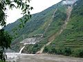
Small hydroelectric plant next to the Salween River in Yunnan


See also
 In Spanish: Río Salween para niños
