San Andrés del Rabanedo facts for kids
Quick facts for kids
San Andrés del Rabanedo
|
||
|---|---|---|

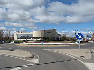
San Andrés del Rabanedo Town Hall, in León (Spain)
|
||
|
||
| Country | Spain | |
| Autonomous community | Castile and León | |
| Province | León | |
| Municipality | San Andrés del Rabanedo | |
| Area | ||
| • Total | 64.84 km2 (25.03 sq mi) | |
| Elevation | 854 m (2,802 ft) | |
| Population
(2018)
|
||
| • Total | 30,820 | |
| • Density | 475.32/km2 (1,231.08/sq mi) | |
| Time zone | UTC+1 (CET) | |
| • Summer (DST) | UTC+2 (CEST) | |
San Andrés del Rabanedo is a town in Spain. It is a municipality located in the Province of León, which is part of the Castile and León region. It is the third largest town in the province. Only León and Ponferrada are bigger.
In 2011, about 31,562 people lived here. The municipality includes several smaller areas. These are San Andrés del Rabanedo itself, Trobajo del Camino, Barrio Pinilla, Villabalter, and Ferral del Bernesga.
Contents
Exploring San Andrés del Rabanedo's Location
San Andrés del Rabanedo is the second most populated town in the Tierras de León area. Only the capital city, León, has more people.
Rivers and Mountains in the Area
The town is in the valley of the River Bernesga. This river starts in the Cantabrian Mountains. It flows south through the Province of León. Eventually, it joins the River Esla. The valley where the town sits is about 840 meters (2,756 feet) above sea level.
Understanding the Landscape
Next to the river, there is a steep slope. This slope has small valleys called gullies. Above this, there is a gently sloping area of moorland. Farmers grow cereals here. Even higher up, at about 1,100 meters (3,609 feet), you find an upland region. This area has natural forests of oak and pine trees.
Neighboring Towns and Military Land
The city of León is to the east and south of San Andrés del Rabanedo. To the southeast, you'll find Valverde de la Virgen. To the west is Cimanes del Tejar. To the northwest, there's Rioseco de Tapia. Finally, to the north are Sariegos and Cuadros. About one-third of the municipality's land is used by a military base. This base is called Conde de Gazola.
Population Growth in San Andrés del Rabanedo
The municipality of San Andrés del Rabanedo covers an area of 64.84 square kilometers (25.03 square miles). In 2011, it had 31,562 people. This means there were about 486 people living in each square kilometer.
How the Population Has Changed
The population in the Province of León has grown since the early 1900s. However, this growth has mostly been in towns and cities. People have moved from rural areas to urban ones. San Andrés del Rabanedo is one of the towns that grew very fast. Its population increased by almost 24,000 people in the 20th century. By 2008, it had gained another 4,000 people.
See also
 In Spanish: San Andrés del Rabanedo para niños


