
San Francisco, Cundinamarca facts for kids
Quick facts for kids
San Francisco
|
|||
|---|---|---|---|
|
Municipality and town
|
|||
 |
|||
|
|||
| Motto(s):
Manos a la obra
|
|||

Location of San Francisco in Cundinamarca
|
|||
| Country | |||
| Department | |||
| Region | Gualivá Province | ||
| Foundation | 22 de noviembre de 1857 | ||
| Area | |||
| • Municipality and town | 118 km2 (46 sq mi) | ||
| Elevation | 1,520 m (4,990 ft) | ||
| Population
(2005)
|
|||
| • Municipality and town | 8,187 | ||
| • Density | 69.38/km2 (179.7/sq mi) | ||
| • Urban | 2,851 | ||
| Time zone | UTC-5 | ||
| Area code(s) | 57 + 1 | ||
| Website | Official Site: http://www.sanfrancisco-cundinamarca.gov.co/ | ||
.svg)
.svg)
San Francisco, also known as San Francisco de Sales, is a town and municipality in Colombia. It is located in the Cundinamarca region.
Contents
Exploring San Francisco's Location
San Francisco is surrounded by other towns. To the north is Supatá, and to the west is La Vega. Facatativá is to the south, El Rosal to the southeast, and Subachoque to the east.
About one-third of the people in San Francisco live in the main town. The rest live in smaller rural areas. These areas include Arrayán, El Peñón, Juan de Vera, La Laja, Muña, Pueblo Viejo, Sabaneta, San Antonio, San Miguel, and Tóriba.
Climate and Environment
The municipality has a mix of mild and cold weather zones. It also has a type of high-altitude grassland known as páramo bajo.
The average temperature in most of the area is about 20 degrees Celsius (68 degrees Fahrenheit). It gets about 1.493 meters (58.8 inches) of rain each year.
San Francisco is only about 52 kilometers (32 miles) from Bogotá, the capital city. Its pleasant climate, beautiful scenery, and water sources make it a popular place for visitors.
San Francisco is part of the Diocese of Facatativá.
A Look Back: San Francisco's History
Long ago, the area was home to two main groups of people: the Panches and the Muisca. The Panches were part of the Carib family, and the Muisca were part of the Chibcha family.
The Muisca lived in the southeastern part of what is now San Francisco. They built a fort there. This fort helped stop the Panche people from entering the Bacatá Confederation. The leader of this confederation was called the Zipa, and it was located in the Sabana de Bogota.
Colonial Times and Land Ownership
During the time of Spanish rule, six encomiendas were created near the town of Tenjo. These were land grants where indigenous people were assigned to work for Spanish citizens. One of these encomiendas, near Subachoque, was given to a Spanish citizen named Don Juan de Vera.
Later, around 1605, Don Juan de Vera traded his encomienda for another property. Then, around 1750, Pedro Pulido from Tenjo bought these lands. In 1828, Francisca Sánchez bought the property from Pulido. She later married Francisco Convers in 1833. After 1850, they built a new house called La Carlina. The old encomienda mansion was very old and worn out.
The Town Begins to Grow
At that time, about 800,000 people lived in the region. They worked hard, often clearing forests, which helped them live comfortably. As more people moved to the area, they needed a central place. They wanted a town where civil authorities could help solve problems, as it was a long journey to La Vega.
In 1855, Father Santos Maria Camero became the priest of La Vega. One day, he saw the beautiful plain where San Francisco now stands and was very impressed. He learned that the local people wanted a town. He asked Francisca Sanchez de Convers to donate land for a church and a village. She agreed.
By 1856, Father Santos helped divide the land into 41 plots. Twenty houses with thatched roofs and dirt floors were built. On January 29, 1857, a group came to decide if the village could become a municipality. They met with Francisca Sanchez, Francisco Convers, and other important people.
It was a special day because it was the feast day of Saint Francis de Sales. Since the landowners were named Francisca and Francisco, everyone agreed to name the community San Francisco de Sales. The church would also have this saint as its patron.
Becoming a Municipality
On August 15, 1857, the Archbishop of Bogota officially created the parish. Father Santos Maria Camero became its first pastor. The priest and his community then asked the Assembly of the State of Cundinamarca to make San Francisco a municipality.
On November 21, 1857, the Assembly approved the request. San Francisco became a new municipality in the Department of Zipaquira. The Assembly also ordered that the village's land be expanded to nine hectares. They also ordered the building of public offices and a jail.
Later, due to a civil war in 1859, Francisca Sanchez sold her land to Dr. Senen Gutiérrez Castillo. On February 2, 1873, he gave the nine hectares of land to Fray Blas Lombana, as the Assembly had ordered.
Education and Services
In 1884, the first school for both boys and girls was started. In 1895, the mayor Rogelio Alvarado and priest Florentino Sarmiento opened a Post & Telegraph office.
In the early 1900s, the main farm, Hacienda La Carlina, was owned by Ricardo Jaramillo and his wife Carlina. Later, Dr. Samuel Hoyos Arango bought the farm.
In 1928, the first power plant was built. It was owned by Don Jose de la Cruz Florez. This plant had problems and stopped working. The town was without electricity for several years. In 1948, Jorge Escallón and Jacobo Flórez opened a new power plant. It was located by the San Miguel River.
The current main church and the priest's house were built between 1943 and 1953. This happened when Father José Arquímedes Castro was the town priest.
In 1935, Eduardo and Hernando Luque started the first boys' school. It became a church school and was later named "Colegio Divino Niño." In the same year, Father Joaquín Luna Serrano started a farm school for children in need. In 1943, Esther Melo and her daughter Anita started the first girls' school, "El Perpetuo Socorro." It was also later renamed "Colegio Divino Niño."
In 1965, Father Francisco Jimenez gave the church schools to the Cundinamarca Department. The boys' and girls' schools were combined. They were then called "Colegio Departamental Integrado Divino Niño" (Divine Child Integrated Departmental School).
Fun Things to Do: Tourism
San Francisco is home to a special place called El Jardin Encantado. This is a sanctuary for hummingbirds and a popular spot for tourists to visit.
Weather in San Francisco
| Climate data for San Francisco (Sabaneta), elevation 2,475 m (8,120 ft), (1981–2010) | |||||||||||||
|---|---|---|---|---|---|---|---|---|---|---|---|---|---|
| Month | Jan | Feb | Mar | Apr | May | Jun | Jul | Aug | Sep | Oct | Nov | Dec | Year |
| Mean daily maximum °C (°F) | 17.7 (63.9) |
17.7 (63.9) |
17.5 (63.5) |
17.9 (64.2) |
18.2 (64.8) |
18.1 (64.6) |
17.8 (64.0) |
17.9 (64.2) |
18.1 (64.6) |
17.8 (64.0) |
17.4 (63.3) |
17.2 (63.0) |
17.8 (64.0) |
| Daily mean °C (°F) | 13.2 (55.8) |
13.5 (56.3) |
13.5 (56.3) |
14.0 (57.2) |
14.2 (57.6) |
14.1 (57.4) |
13.7 (56.7) |
13.7 (56.7) |
13.8 (56.8) |
13.6 (56.5) |
13.5 (56.3) |
13.3 (55.9) |
13.7 (56.7) |
| Mean daily minimum °C (°F) | 9.2 (48.6) |
9.6 (49.3) |
9.9 (49.8) |
10.3 (50.5) |
10.4 (50.7) |
10.1 (50.2) |
9.8 (49.6) |
9.8 (49.6) |
9.7 (49.5) |
9.8 (49.6) |
9.8 (49.6) |
9.4 (48.9) |
9.8 (49.6) |
| Average precipitation mm (inches) | 86.1 (3.39) |
123.9 (4.88) |
176.3 (6.94) |
152.6 (6.01) |
114.9 (4.52) |
61.2 (2.41) |
52.8 (2.08) |
55.9 (2.20) |
76.5 (3.01) |
175.9 (6.93) |
218.3 (8.59) |
161.7 (6.37) |
1,411.9 (55.59) |
| Average precipitation days | 17 | 16 | 21 | 22 | 22 | 19 | 19 | 20 | 18 | 22 | 23 | 20 | 232 |
| Average relative humidity (%) | 87 | 88 | 89 | 89 | 88 | 86 | 85 | 85 | 86 | 87 | 89 | 88 | 87 |
| Mean monthly sunshine hours | 136.4 | 118.6 | 105.4 | 96.0 | 111.6 | 123.0 | 139.5 | 142.6 | 123.0 | 111.6 | 105.0 | 117.8 | 1,430.5 |
| Mean daily sunshine hours | 4.4 | 4.2 | 3.4 | 3.2 | 3.6 | 4.1 | 4.5 | 4.6 | 4.1 | 3.6 | 3.5 | 3.8 | 3.9 |
| Source: Instituto de Hidrologia Meteorologia y Estudios Ambientales | |||||||||||||
Images for kids
-
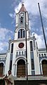
Parish church in the center of San Francisco de Sales
-
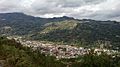
San Francisco de Sales. View from a hill
-
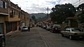
A street near the center of San Francisco de Sales
-
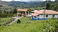
A hacienda in San Francisco de Sales


See also
 In Spanish: San Francisco de Sales (Cundinamarca) para niños
