San Gregorio de Polanco facts for kids
Quick facts for kids
San Gregorio de Polanco
|
|
|---|---|
|
City
|
|

San Gregorio de Polanco, Uruguay
|
|
| Country | |
| Department | Tacuarembó Department |
| Founded | 1853 |
| Population
(2011 Census)
|
|
| • Total | 3,415 |
| Time zone | UTC -3 |
| Postal code |
45200
|
| Dial plan | +598 4369 (+4 digits) |
San Gregorio de Polanco is a small city in Uruguay. It is located in the Tacuarembó Department, which is in the north-central part of the country.
Contents
Where is San Gregorio de Polanco?
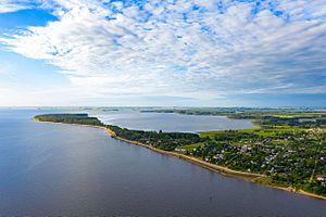
This city sits on a piece of land surrounded by water, called a peninsula. It is on the northern shore of the Rincón del Bonete Lake. This lake is not natural; it was created by people.
San Gregorio de Polanco is also located along Route 43. This road is about 140 kilometers (about 87 miles) south of Tacuarembó, the capital city of the department. To cross the lake on Route 43 and reach the Durazno Department, you need to take a ferryboat.
A Look at San Gregorio de Polanco's History
San Gregorio de Polanco was founded a long time ago, on November 27, 1853.
Over the years, its official status changed:
- On October 13, 1963, it became known as a "Villa," which means a town.
- Then, on December 13, 1994, it was officially named a "Ciudad," meaning a city.
A big change happened in 1945 when the artificial Rincón del Bonete Lake was created. This huge lake completely changed the area around the town. It added a large water surface and, later, even beaches.
How Many People Live Here?
In 2011, about 3,415 people lived in San Gregorio de Polanco. The number of people living in the city has changed quite a bit over the years.
| Year | Population |
|---|---|
| 1908 | 6,004 |
| 1963 | 2,489 |
| 1975 | 2,877 |
| 1985 | 2,856 |
| 1996 | 3,101 |
| 2004 | 3,673 |
| 2011 | 3,415 |
Source: Instituto Nacional de Estadística de Uruguay (National Institute of Statistics of Uruguay)
Important Buildings
- Parish Church of Our Lady of Mt. Carmel: This is a local church where people go to worship.
See also
 In Spanish: San Gregorio de Polanco para niños
 | Mary Eliza Mahoney |
 | Susie King Taylor |
 | Ida Gray |
 | Eliza Ann Grier |


