San Mateo de Alajuela facts for kids
Quick facts for kids
San Mateo
|
|
|---|---|
|
District
|
|

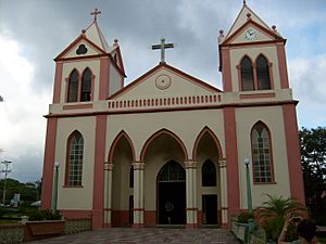
Front of Catholic Church in San Mateo
|
|
| Country | |
| Province | Alajuela |
| Canton | San Mateo |
| Area | |
| • Total | 64.85 km2 (25.04 sq mi) |
| Elevation | 254 m (833 ft) |
| Population
(2011)
|
|
| • Total | 2,692 |
| • Density | 41.511/km2 (107.513/sq mi) |
| Time zone | UTC−06:00 |
| Postal code |
20401
|
San Mateo is a special area called a district. It is part of the San Mateo canton. This canton is located in the Alajuela province of Costa Rica.
Contents
Where is San Mateo?
San Mateo is a district in Costa Rica. It covers about 64.85 square kilometers. The land is about 254 meters above sea level. It is located in the lowlands near Costa Rica's central Pacific coast.
San Mateo is 31 kilometers east of Caldera Port. It is also 44 kilometers southwest of Alajuela, the capital city of its province. The national capital city, San Jose, is 53 kilometers away.
How Many People Live Here?
| Historical population | |||
|---|---|---|---|
| Census | Pop. | %± | |
| 1883 | 246 | — | |
| 1892 | 701 | 185.0% | |
| 1927 | 2,180 | 211.0% | |
| 1950 | 3,058 | 40.3% | |
| 1963 | 2,876 | −6.0% | |
| 1973 | 1,553 | −46.0% | |
| 1984 | 1,988 | 28.0% | |
| 2000 | 2,529 | 27.2% | |
| 2011 | 2,692 | 6.4% | |
|
Instituto Nacional de Estadística y Censos |
|||
Every few years, Costa Rica counts its population. This is called a census. For the 2011 census, San Mateo had 2,692 people living there.
Getting Around San Mateo
Road Transportation
People in San Mateo use roads to travel. The district has two main road routes:
These roads help people get to and from San Mateo. They connect the district to other towns and cities.
See also
 In Spanish: San Mateo (Costa Rica) para niños
 | Stephanie Wilson |
 | Charles Bolden |
 | Ronald McNair |
 | Frederick D. Gregory |


