
San Salvador (volcano) facts for kids
Quick facts for kids San Salvador Volcano (Quezaltepeque) |
|
|---|---|
.jpg)
The San Salvador volcano is instantly recognizable by its distinctive triangular crescent pointed apex, which has a dorsal fin-like shape.
|
|
| Highest point | |
| Elevation | 1,893 m (6,211 ft) |
| Geography | |

San Salvador Volcano (Quezaltepeque)
Location in El Salvador
|
|
| Geology | |
| Mountain type | Stratovolcano |
| Last eruption | June to November 1917 |
The San Salvador Volcano is a large mountain in El Salvador. It is also known as Quezaltepeque or El Boquerón. This volcano is located northwest of the city of San Salvador.
A volcano like this one is called a stratovolcano. This means it is tall and cone-shaped. It is built up by many layers of hardened lava, ash, and rocks.
The main crater of the San Salvador Volcano has been mostly filled. This happened because a newer part, called the Boquerón volcano, grew inside it. The city of San Salvador is very close to the volcano. Some parts of the city are even on its lower slopes.
Because it is so close, any activity from the volcano could be dangerous. This includes eruptions or even just ground movement. Despite this, the volcano is a famous symbol of the city. Many TV and radio antennas are placed on its highest points. The highest peak is called El Picacho, which is 1,960 meters tall.
The Boquerón Part of the Volcano


The main part of the volcano is called the Boquerón edifice. It formed about 700 to 1,000 years ago. It grew inside an older, larger crater called a caldera. A caldera is a big bowl-shaped hollow that forms after a volcano erupts and collapses.
You can still see a curved ridge on the northeast side of the volcano. This is what's left of the old caldera rim. The lava from the Boquerón part has more alkali elements and iron than the older lava.
About 800 years ago, the volcano had a huge explosion. This explosion created the crater we see today. The crater is called "Boquerón," which means "big mouth" in Spanish. It is about 1.5 kilometers wide and 500 meters deep. Local people who live on the volcano even grow crops on the upper walls inside the crater.
Deep inside the volcano, there is a chamber filled with molten rock, called magma. There are also cracks, or fissures, that go from this chamber to the sides of the volcano. The fissure on the northwest side has been the most active recently.
One important eruption from this fissure was the Loma Caldera eruption. This eruption buried an ancient village called Ceren. Another eruption was El Playon, which happened between 1658 and 1671. It covered the town of Nexapa. The people moved to a new town called Nejapa. Today, they celebrate this eruption every year.
The most recent eruption was in 1917. This eruption happened on the side of the volcano, along the northwest fissure. Before this, there was a lake inside the Boquerón crater. During the eruption, this crater lake dried up. A small, cone-shaped hill of volcanic rock appeared inside the crater. People named this new hill 'Boqueroncito', meaning 'little big mouth'.
Gallery
-
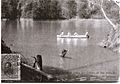
A 1914 postcard showing the lagoon in the crater of San Salvador Volcano. The lagoon disappeared when the volcano erupted in 1917.
-
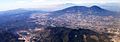
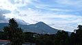
The large San Salvador volcano stands tall west of the city of San Salvador.
-
The massive San Salvador volcano dominates the landscape west of El Salvador's capital city.
-
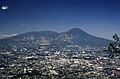
The San Salvador skyline with the volcano behind it.
-
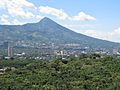
A view of San Salvador volcano.
-
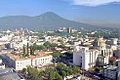
View of San Salvador Volcano from downtown San Salvador.
-
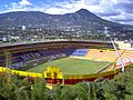
San Salvador Volcano seen from Cuscatlán Stadium.
-
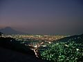
San Salvador volcano towering over San Salvador city at night.


See also
 In Spanish: Volcán de San Salvador para niños
- List of volcanoes in El Salvador
