
Lake Ilopango facts for kids
Quick facts for kids Lake Ilopango |
|
|---|---|

Westward view from lake Ilopango, aft San Salvador Metropolitan Area and San Salvador (volcano) lie just ahead
|
|
| Highest point | |
| Elevation | 450 m (1,480 ft) |
| Geography | |

Lake Ilopango
Location in El Salvador
|
|
| Location | El Salvador |
| Geology | |
| Mountain type | Caldera |
| Last eruption | 1879 to 1880 |
| Lake Ilopango | |
|---|---|

Eastward view from San Salvador (volcano), San Salvador Metropolitan Area at the center and aft, the ilopango caldera lies just behind along with San Vicente (volcano)
|
|
|
Lake Ilopango
Location in El Salvador
|
|
| Location | Central El Salvador |
| Coordinates | 13°40′N 89°03′W / 13.67°N 89.05°W |
| Type | crater lake |
| Basin countries | El Salvador |
| Max. length | 11 km (6.8 mi) |
| Max. width | 8 km (5.0 mi) |
| Surface area | 72 km2 (28 sq mi) |
| Max. depth | 230 m (750 ft) |
| Surface elevation | 440 m (1,440 ft) |
| Islands | Islas Quemadas |
Lake Ilopango is a large crater lake in central El Salvador. It fills a huge bowl-shaped area called a caldera, which was formed by a volcano. The lake is about 8 by 11 kilometers wide, covering 72 square kilometers. It is the second largest lake in El Salvador.
The lake is located right next to the capital city, San Salvador. Its edges are like a scalloped rim, ranging from 100 to 500 meters high. Any extra water from the lake flows into the Jiboa River, which then goes to the Pacific Ocean. Near the lake is the Ilopango International Airport. This airport hosts yearly airshows where pilots from around the world fly over San Salvador City and Lake Ilopango.
Contents
Volcanic History of Lake Ilopango
Lake Ilopango was formed by powerful volcanic eruptions. Scientists have found evidence of four major eruptions. These eruptions happened over a long time, during the late Pleistocene and Holocene periods. They created huge clouds of ash and hot gas that covered much of the country.
The Big Eruption: Tierra Blanca Joven
The most recent big eruption happened sometime between 410 and 535 AD. This event caused the volcano to collapse, forming the caldera we see today. It produced massive flows of hot ash and gas, which destroyed many Mayan cities.
Recent studies suggest this eruption might have happened in 431 AD. Scientists found clues in ice cores from Greenland and Antarctica. They also used radiocarbon dating on a burnt tree found in the ash. This eruption was incredibly powerful, releasing about 84 cubic kilometers of ash. To give you an idea, that's many times more than the 1980 eruption of Mount St. Helens! It was rated a 6 on the Volcanic Explosivity Index (VEI).
The ash from this eruption covered an area of at least 10,000 square kilometers. It was so thick that it would have stopped all farming in the area for many decades. Some experts even think this eruption led to the abandonment of the ancient city of Teotihuacan. It was one of the biggest volcanic events on Earth in the last 7,000 years.
Later Eruptions and Islas Quemadas
After the huge 431 AD eruption, smaller eruptions created new landforms. Several lava domes formed inside the lake and near its shore.
The only eruption that people have recorded happened from December 31, 1879, to March 26, 1880. This eruption also created a lava dome. It was rated a 3 on the VEI. This lava dome grew until it reached the surface of the lake. It formed the small islands known today as Islas Quemadas.
Activities and Events at Lake Ilopango
Lake Ilopango is a popular spot for different activities.
On July 5, 2004, a famous illusionist named Francis Fanci performed a trick there. He was put into a trunk and submerged in the lake. He reappeared after thirty seconds!
The lake is also used for training. For example, in 2014, U.S. soldiers and Salvadoran service members trained together over Lake Ilopango. They practiced jumping from a U.S. Army CH-47 Chinook helicopter.
See also
 In Spanish: Lago de Ilopango para niños
- List of volcanoes in El Salvador
- Volcanic winter of 536
- Year Without a Summer
- Tierra Blanca Joven eruption
Images for kids
-
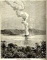
Engraving of the eruption of the Ilopango volcano, 1891
-
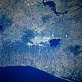
The San Salvador Metropolitan Area is pinned between the volcano San Salvador and Lake Ilopango Caldera. The Pacific Coast is adjacent south of the city
-
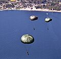
U.S. soldiers with the 7th Special Forces Group and Salvadoran service members maneuver after jumping from the ramp of a U.S. Army CH-47 Chinook helicopter during a joint training exercise over Lake Ilopango, El Salvador, January 21, 2014


.jpg)
