Sank, Missouri facts for kids
Quick facts for kids
Sank, Missouri
|
|
|---|---|

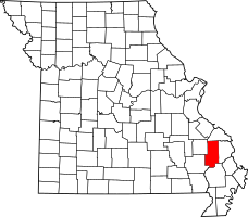
Location of Bollinger County, Missouri
|
|
| Country | United States |
| State | Missouri |
| County | Bollinger |
| Township | Liberty |
| Elevation | 397 ft (121 m) |
| Time zone | UTC-6 (Central (CST)) |
| • Summer (DST) | UTC-5 (CDT) |
| Area code(s) | 573 |
| GNIS feature ID | 741240 |
Sank is a small, quiet place in Missouri, United States. It's called an "unincorporated community." This means it doesn't have its own city government. Sank is located in Bollinger County, within Liberty Township. You can find it about one mile north of Missouri Route 51.
Two creeks, Clubb Creek and Hawker Creek, meet nearby. There's also the Sank State Wildlife Area close by. Other towns like Zalma, Dongola, and Marble Hill are a few miles away.
The Story of Sank's Name
Have you ever wondered how places get their names? The community of Sank got its name from a man named Jasper Cooper. He owned a store in the area. In 1915, he wanted to open a post office there.
When it was time to choose a name, Jasper Cooper picked "Sank." This was the nickname of his good friend, "Sank" Fowler. Mr. Fowler was a well-known person in the community. The post office was open for many years, from 1912 to 1920, and then again from 1925 to 1954.
 | May Edward Chinn |
 | Rebecca Cole |
 | Alexa Canady |
 | Dorothy Lavinia Brown |

