Sant Celoni facts for kids
Quick facts for kids
Sant Celoni
|
|||
|---|---|---|---|
|
Municipality
|
|||

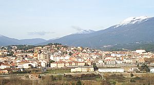
View of Sant Celoni with the Montseny Massif in the background
|
|||
|
|||
| Country | |||
| Community | |||
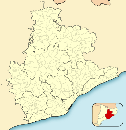
| Province | Barcelona | ||
| Comarca | Vallès Oriental | ||
| Area | |||
| • Total | 65.2 km2 (25.2 sq mi) | ||
| Elevation | 152 m (499 ft) | ||
| Population
(2018)
|
|||
| • Total | 17,754 | ||
| • Density | 272.30/km2 (705.3/sq mi) | ||
| Demonym(s) | Celoní, celonina | ||
Sant Celoni (pronounced like "san suh-LOH-nee") is a town in Catalonia, Spain. It is located in the Vallès Oriental region. The town sits in the valley of the Tordera river. It is nestled between the Montseny and Montnegre mountain ranges.
Most of Sant Celoni is on the left side of the Tordera river. The areas of Montnegre and Olzinelles used to be separate towns. Now, they are part of Sant Celoni. This makes Sant Celoni the largest area in its region. The town is easy to reach by the AP-7 Motorway and the C-251 road. It also has a train station on the RENFE line between Barcelona and Girona.
Contents
Exploring Sant Celoni's Geography
The town of Sant Celoni includes its main center, which is the most populated area. It also has several smaller villages and scattered groups of homes.
Main Areas and Villages
The urban area of Pertegàs is very close to the town center. It is now seen as another neighborhood of the city. The old church of Sant Martí de Pertegàs was actually where the town first started.
La Batllòria is the largest village outside the main town. It is located at the northern edge of Sant Celoni. It is near Riells and Viabrea.
Vilardell is a village built around the church of Sant Llorenç. It is located at the foot of the Montnegre mountains. This place is famous for the old legend of Soler de Vilardell and a dragon!
Smaller Villages and Natural Park Areas
Other smaller villages are spread out within the Montnegre natural park. These include Olzinelles in the south, which has farmhouses around the church of Sant Esteve. Fuirosos is to the east, with homes near the church of Sant Cebrià. Montnegre is in the southeast, with farmhouses around the church of Sant Martí de Montnegre.
These villages used to be independent towns. They became part of Sant Celoni between 1930 and 1936. Montnegre was once the center of the Barony of Montnegre. Olzinelles also had its own local government.
New Neighborhoods
Over time, people moved away from farming and forest work. But new neighborhoods have grown in the Montnegre area since the 1950s. These include Can Coll, Cal Batlle, and the Boscos del Montnegre. They have become places where people live all year round.
The main town of Sant Celoni is also divided into many neighborhoods. Some of these are Les Borrelles, Can Sans, Illes Belles, Sant Ponç, and El Pertegàs. Others include Carrer Major de Baix, Carrer Mayor de Dalt, and Molí Paperer. There are also Zona Residencial dels Esports, Turó Mare de Déu del Puig, Avinguda de la Pau, El Sot de les Granotes, and Pla de Palau.
Sant Celoni's History
The town of Sant Celoni got its name from a small chapel. This chapel was built around the 11th century near the Pertegàs river. The name "Sant Celoni" comes from the Latin words Sanctum Celedonium and Sancti Celedonii. These refer to Saint Celedonius. Over the centuries, the name has been spelled in many different ways. Some examples are Sancti Celidonia, Sant Celdoni, and Sent Salony.
Sant Celoni's Economy
The way people make a living in Sant Celoni has changed a lot. Farming is not as important as it used to be. Today, only a small amount of cereals and animal feed crops are grown.
Industry and Construction
Industry has been very important for Sant Celoni's growth. The chemical industry is strong here. There are also many metal and electronics companies. These industries have grown a lot recently. Because so many businesses are growing, new industrial areas have been built. This has brought even more different types of industries to the town.
The construction industry is also very active in Sant Celoni. It has seen a lot of growth in recent years.
Trade and Services
Sant Celoni is still an important and modern center for trade. It has a lively weekly market every Wednesday. This market attracts many people from nearby areas. A new shopping center has also been built. It has cinemas, restaurants, pubs, a supermarket, and many shops.
In 2001, only a small part of the population worked in farming (1.4%). Construction employed 11.1% of people. Industry employed 30.5%. The biggest sector was services, with 57% of the population working in it.
Population of Sant Celoni
| 1900 | 1930 | 1950 | 1970 | 1986 | 2012 |
|---|---|---|---|---|---|
| 3,301 | 4,192 | 4,923 | 9,325 | 11,275 | 17,076 |
Sant Celoni's population has grown steadily over the years. In 1900, about 3,300 people lived here. By 1970, the population had nearly tripled to over 9,300. In 2012, the town had over 17,000 residents. This shows how Sant Celoni has developed and attracted more people.
Getting Around: Communications
Sant Celoni has excellent ways to connect with other places. The AP-7 motorway and the C-35 main road link Sant Celoni to the rest of Catalonia and even France. There is also a railway line that makes travel easy. The town also has a good bus system for local and regional travel.
See also
 In Spanish: Sant Celoni para niños
 | Stephanie Wilson |
 | Charles Bolden |
 | Ronald McNair |
 | Frederick D. Gregory |


