Santa Cruz District, Santa Cruz, Guanacaste facts for kids
Quick facts for kids
Santa Cruz
|
|
|---|---|
|
District
|
|

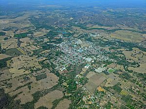
The town of Santa Cruz, administrative center of the canton and district of Santa Cruz
|
|
| Country | |
| Province | Guanacaste |
| Canton | Santa Cruz |
| Area | |
| • Total | 289.6 km2 (111.8 sq mi) |
| Elevation | 50 m (160 ft) |
| Population
(2011)
|
|
| • Total | 21,544 |
| • Density | 74.392/km2 (192.68/sq mi) |
| Time zone | UTC−06:00 |
| Postal code |
50301
|
Santa Cruz is a district located in the Guanacaste area of Costa Rica. It is part of the larger Santa Cruz canton.
Contents
Geography of Santa Cruz
Santa Cruz covers an area of about 289.6 square kilometers. This is roughly the size of 28,960 football fields! The district is located about 50 meters (164 feet) above sea level.
Towns and Villages
The main town and administrative center of the district is also called Santa Cruz.
Many other villages are part of this district. These include Ángeles, Arado, Bernabela, Cacao, Cinto, Conga, Cuatro Esquinas, Chibola, Chircó, Chumico, Guayabal, Hato Viejo, Lagunilla, Lechuza, Limón, Moya, and Puente Negro. You can also find Retallano (partly), Rincón, Río Caño Viejo, San Juan, San Pedro, and Vistamar here.
Population of Santa Cruz
Demographics is the study of how many people live in a place and what they are like. According to the 2011 census, Santa Cruz had a population of 21,544 people.
Here's how the population has grown over the years:
- 1883: 660 people
- 1927: 3,976 people
- 1950: 5,232 people
- 1963: 8,028 people
- 1973: 10,672 people
- 1984: 12,866 people
- 2000: 17,486 people
- 2011: 21,544 people
Transportation
Road Connections
Several important roads help people travel in and out of Santa Cruz. These roads connect the district to other parts of Costa Rica.
See also
 In Spanish: Santa Cruz (Costa Rica) para niños


