
Guanacaste Province facts for kids
Quick facts for kids
Province of Guanacaste
Provincia de Guanacaste
|
|||
|---|---|---|---|

Landscape of Guanacaste
|
|||
|
|||

Location of the Province of Guanacaste
|
|||
| Country | Costa Rica | ||
| Capital city | Liberia | ||
| Area | |||
| • Total | 10,140.71 km2 (3,915.35 sq mi) | ||
| Population
(2011)
|
|||
| • Total | 326,953 | ||
| • Density | 32.24163/km2 (83.50543/sq mi) | ||
| Demonym(s) | Guanacasteco | ||
| ISO 3166 code | CR-G | ||


Guanacaste is a beautiful province located in the northwestern part of Costa Rica. It shares a border with Nicaragua. The main city and capital of Guanacaste is Liberia.
Contents
What's in a Name? The Guanacaste Tree
The province gets its name from the guanacaste tree. This special tree is also called the ear pod tree. It's so important that it's the national tree of Costa Rica!
Where is Guanacaste Located?
The Guanacaste province has several neighbors. To the east, it borders the Alajuela province. To the southeast and southwest, you'll find the Puntarenas province. The vast Pacific Ocean lies to the south and west. And to the north, Guanacaste shares a border with Nicaragua.
 |
Nicaragua | |
||
| Pacific Ocean | Alajuela | |||
| Puntarenas | Pacific Ocean (Gulf of Nicoya) | Puntarenas |
Exploring Guanacaste's Geography
Guanacaste is the second largest province in Costa Rica. It covers an area of about 10,140.71 km2 (3,915.35 sq mi). It is located in the northwest of Costa Rica, right along the Pacific Ocean.
Most of the land in Guanacaste is flat or has small hills. However, the Cordillera de Guanacaste (Guanacaste mountain range) runs along its border with the Alajuela. This mountain range is home to four important volcanos:
- Miravalles, which is 2,028 m (6,654 ft) high.
- Tenorio, standing at 1,916 m (6,286 ft) high.
- Rincón de la Vieja, an active volcano, 1,806 m (5,925 ft) high.
- Orosí, an inactive volcano, 1,440 m (4,720 ft) high.
Who Lives in Guanacaste?

The people who live in Guanacaste are called Guanacastecos. If they are women, they are called Guanacastecas.
In 2011, the Guanacaste province had a population of 326,953 people. This means there were about 32.2 inhabitants per square kilometer. It is the province with the lowest population density in Costa Rica. The canton of Liberia has the most people, with 62,987 inhabitants.
How Guanacaste is Divided: Cantons and Districts
The Guanacaste province is split into 11 main areas called cantons. Each canton is then divided into smaller areas called Districts. There are 59 districts in total.

| No. | Canton | Capital City | Number of Districts | Population (2011) |
Area (km²) |
People per km² |
|---|---|---|---|---|---|---|
| 1 | Liberia | Liberia | 5 | 62,987 | 1,436.47 | 43.8 |
| 2 | Nicoya | Nicoya | 7 | 50,825 | 1,333.68 | 38.1 |
| 3 | Santa Cruz | Santa Cruz | 9 | 55,104 | 1,312.27 | 42.0 |
| 4 | Bagaces | Bagaces | 4 | 19,536 | 1,273.49 | 15.3 |
| 5 | Carrillo | Filadelfia de Guanacaste | 4 | 37,122 | 577.54 | 64.3 |
| 6 | Cañas | Cañas | 5 | 26,201 | 682.20 | 38.4 |
| 7 | Abangares | Las Juntas | 4 | 18,039 | 675.76 | 26.7 |
| 8 | Tilarán | Tilarán | 7 | 19,640 | 638.39 | 30.8 |
| 9 | Nandayure | Carmona | 5 | 11,121 | 565.59 | 19.7 |
| 10 | La Cruz | La Cruz de Guanacaste | 4 | 19,181 | 1,383.90 | 13.9 |
| 11 | Hojancha | Hojancha | 4 | 7,197 | 261.42 | 27.5 |
Guanacaste's Economy: How People Make a Living
The main way people earn money in Guanacaste is through farming. Raising cattle is very important here. Farmers also grow crops like cotton, sugarcane, and rice.
Some areas, like those around the city of Alajuela, have many factories. These factories make goods mainly for export to other countries. They are often located in special "free trade zones."
Tourism is also a big part of the economy. Many people visit Guanacaste because of its beautiful beaches, like Playas del Coco and Playa Tamarindo. The sunny, dry season is perfect for tourists, especially during the winter months in colder countries. Many visitors also enjoy exploring the national parks in the province.
Images for kids
-
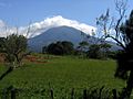
The Rincón de la Vieja volcano.
-
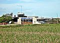
A sugar mill in Filadelfia.
-
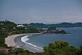
The beautiful Playas del Coco beach.
-
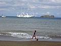
A beach in the Guanacaste Province.
-
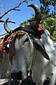
Typical headdress of Costa Rican oxen.


See also
 In Spanish: Provincia de Guanacaste para niños
