Santa Rosa, Guyana facts for kids
Quick facts for kids
Santa Rosa
|
|
|---|---|

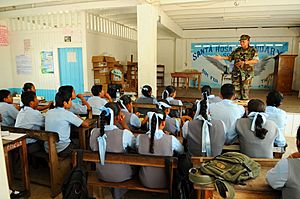
Santa Rosa Secondary School
|
|
| Country | |
| Region | Barima-Waini |
| Population
(2012)
|
|
| • Total | 913 |
Santa Rosa is a community in the Barima-Waini region of northern Guyana. It is one of the earliest Catholic missions in Guyana, started in 1840. This village is part of the North West Amerindian District.
About Santa Rosa
Santa Rosa is the largest Amerindian settlement in Guyana. In 2012, the village had 913 people. However, the wider area had 6,046 people in 2013. Most people here are from the Arawak group.
The village is located on the Moruka River, about 29 kilometers from where the river meets the sea. Santa Rosa is actually made up of eleven smaller settlements. These are spread out in the Savannah wetlands along a 16-kilometer stretch of the Moruka River. Since 1996, the Moruca Land Council has governed the area, with Santa Rosa as the main center.
Daily Life and Services
The community received electricity in 2004. This happened when a diesel-powered generator was given by Mr. Monty Niathally. He owns a company called Variety Woods and Greenheart Limited.
Santa Rosa has important services for its residents. It has a secondary school called Santa Rosa Secondary School, which opened in 1991. There is also a health center to help people stay healthy. The main way people earn a living here is through subsistence farming. This means they grow food mostly for themselves and their families.
Important People
- Stephen Campbell (1897–1966) was the first Amerindian person to become a member of Parliament in Guyana.
See also
 In Spanish: Santa Rosa (Guyana) para niños


