
Santiago de Veraguas facts for kids
Quick facts for kids
Santiago de Veraguas
santiago
|
|
|---|---|
|
City
|
|

Cathedral in Santiago de Veraguas
|
|
| Nickname(s):
"The Green City"
|
|

Santiago de Veraguas
Location in Panama
|
|
| Country | |
| Province | Veraguas |
| Founded | July 25th, 1621 |
| Area | |
| • Total | 975 km2 (376 sq mi) |
| Elevation | 101 m (331 ft) |
| Population
(2010)
|
|
| • Total | 88,997 |
| • Density | 91.28/km2 (236.41/sq mi) |
| Time zone | UTC-5 (ETZ) |
| Climate | Am |
Santiago de Veraguas is a city in Panama. It is the capital of the Veraguas Province. The city is located in the countryside, right next to the Pan American Highway.
Santiago is surrounded by other districts. To the north is San Francisco District. To the south is Montijo District. The District of Atalaya is to the east, and La Mesa District is to the west. About 60,000 people live here, based on a 2014 count.
Contents
History of Santiago
How Santiago Was Founded
Santiago was founded in the 1600s. People from nearby towns like Montijo and Santa Fe came together. They wanted to create a new city. This city would be a central place for sending out goods and messages.
The city was built south of a river called Martin Grande, also known as Los Chorros. In 1606, Santiago did not exist yet. The Bishop of Panama wrote about the towns in Veragua Province, and Santiago was not on his list.
Early Records of the City
However, old documents show that Santiago was definitely there by 1621. One manuscript from the National Library in Madrid confirms this. Historians believe it was founded in the late 1500s or early 1600s.
A writer named Juan Diez De La Calle said that "the city of Santiago de Veragua was founded on October 23, 1621." This means there were two important times in Santiago's history. The "old" city was founded on October 23, 1621. The "new" city was established in 1637.
Independence and Modern Times
In 1751, Panama was ruled by a military government. This government was called the General Command of the Mainland. It included the Veraguas province.
Panama declared its independence from Spain on November 28, 1821. A few days later, on December 4, 1821, Santiago also declared the Veraguas province free from Spanish rule. Later, on November 9, 1903, Santiago signed an agreement. This agreement joined Panama in its separation from Colombia.
Areas of Santiago
Santiago District includes several smaller areas, called townships. These are Santiago, La Colorada, La Peña, La Raya de Santa María, Ponuga, San Pedro del Espino, Canto del Llano, Los Algarrobos, San Martín de Porres, Urracá, Edwin Fábrega, Carlos Santana Ávila, La Soledad, Rincón Largo, El Llanito, and Rodrigo Luque.
Economy and Jobs
The economy of Santiago is mostly based on a few key areas. These include trade, banking, farming, and raising livestock (like cows). Some smaller industries also exist. For example, pottery is made in towns like La Peña. Leather goods are crafted in La Colorada.
People of Santiago
According to the 2010 National Census, Santiago has a population of 88,997 people.
City Life and Buildings
Santiago is a main transportation center for the Veraguas province. Buses regularly travel from the Terminal de Transporte de Santiago to smaller towns. The city is well-connected to the rest of Panama. It has always been a common stop for people traveling across the country.
Santiago is located in the middle of Panama. This location has helped it grow. Important roads and bridges have been built to connect the Veraguas province. The Pan-American Highway goes right through the city. Public transportation is easy to find for residents.
Unlike some big cities, Santiago does not have many tall skyscrapers. Instead, it has kept more of its old colonial style. Modern buildings are spread out across the city. These are often used for shopping malls, banks, and government offices.
Santiago has many important historical buildings. These show its colonial past. Examples include The Juan Demóstenes Arosemena Normal School, which is a national historical monument. There is also The Regional Museum of Veraguas and the St. James the Apostle Cathedral.
The city has two main hospitals: Hospital Dr. Luis "Chicho" Fábrega and the Dr. Horacio Díaz Gómez Polyclinic. There are also smaller healthcare places. In recent years, Santiago has improved its roads and public spaces. They even buried electric cables on Avenida Central to make the city look nicer.
Visiting Santiago
Santiago is about three and a half hours away from Panama City by car. You can drive there on the Pan-American Highway. It's a popular place for shopping. Many people stop here to buy clothes, medicine, or food before going to other famous places in the province.
Santiago has about 2,000 rooms available for visitors. These include hotels, guesthouses, and temporary apartments. Some popular hotels are Hotel Gran David and Hotel Mykonos. Both are located right on the Pan-American Highway.
City Leaders
Here are some of the mayors who have led Santiago since 1994:
- Maio Luis Delgado (1994-1999)
- Plinio Donoso (1999-2004)
- Ruben Patiño (2004-2009)
- Gonzalo "Chalo" Adames (2009-2014)
- Edward Mosley Ibarra (2014-2019)
- Samid Sandoval (2019-2024)
Geography and Climate
Location and Height
Santiago is located at an elevation of 101 meters (about 331 feet) above sea level.
- Latitude: 8° 6' 20.57" N
- Longitude: 80° 58' 16.06" W
Weather in Santiago
Santiago has a tropical monsoon climate. This means it has a wet season and a dry season. It is generally warm all year round.
| Climate data for Santiago (1971–2000) | |||||||||||||
|---|---|---|---|---|---|---|---|---|---|---|---|---|---|
| Month | Jan | Feb | Mar | Apr | May | Jun | Jul | Aug | Sep | Oct | Nov | Dec | Year |
| Mean daily maximum °C (°F) | 34.4 (93.9) |
35.9 (96.6) |
36.6 (97.9) |
36.6 (97.9) |
35.2 (95.4) |
33.9 (93.0) |
33.7 (92.7) |
33.7 (92.7) |
33.4 (92.1) |
32.9 (91.2) |
32.9 (91.2) |
33.4 (92.1) |
34.4 (93.9) |
| Mean daily minimum °C (°F) | 17.7 (63.9) |
17.9 (64.2) |
18.4 (65.1) |
19.4 (66.9) |
21.0 (69.8) |
21.1 (70.0) |
20.4 (68.7) |
20.5 (68.9) |
20.3 (68.5) |
20.6 (69.1) |
20.1 (68.2) |
18.5 (65.3) |
19.7 (67.4) |
| Average rainfall mm (inches) | 22.5 (0.89) |
16.7 (0.66) |
20.9 (0.82) |
96.7 (3.81) |
313.7 (12.35) |
300.8 (11.84) |
243.0 (9.57) |
317.3 (12.49) |
342.4 (13.48) |
395.5 (15.57) |
259.3 (10.21) |
82.7 (3.26) |
2,411.5 (94.95) |
| Average rainy days (≥ 0.1 mm) | 2.3 | 1.1 | 1.8 | 6.2 | 17 | 18 | 15 | 18 | 20 | 21 | 17 | 6.6 | 144 |
| Source: World Meteorological Organization | |||||||||||||
Images for kids
-
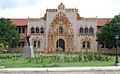
Normal School -
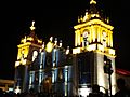
Cathedral Santiago Apostol -
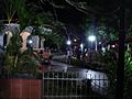
Parque Santiago


See also
 In Spanish: Santiago de Veraguas para niños
